

Path of storm RAGASA
According to the National Center for Hydro-Meteorological Forecasting, at 1:00 a.m. on September 22, the center of super typhoon RAGASA was at about 19.2° North latitude; 124.1° East longitude, about 230 km East-Northeast of Luzong Island (Philippines). The strongest wind near the center of the storm was level 16-17 (184-221 km/h), gusting above level 17. The storm moved west-northwest at a speed of about 20 km/h.
The central East Sea has scattered showers and thunderstorms, the northern Gulf of Tonkin, and the sea area from Gia Lai to Ca Mau has scattered showers and thunderstorms.
During the day and night of September 22, the sea area east of the North East Sea will have winds gradually increasing to level 8-9, then increasing to level 10-14; the area near the storm center will have strong winds of level 15-17, gusting above level 17. The sea will be rough, with waves 6.0-8.0m high, and over 10.0m high near the storm center.
In the central East Sea, the wind is level 5, sometimes level 6; at night it increases to level 6, gusting to level 7-8, rough sea, waves 2.0-3.0m high.
In the sea area from Khanh Hoa to Ho Chi Minh City and the sea area north of the South China Sea (including the north of Truong Sa special zone), wind level 5, sometimes level 6, gusting to level 7-8, rough sea, waves 2.0-3.0m high.
In addition, on the day and night of September 22, in the northern and central areas of the East Sea (including Hoang Sa), the northern Gulf of Tonkin, and the sea area from Gia Lai to Ca Mau, there will be scattered showers and thunderstorms; in particular, in the northeastern part of the East Sea, there will be storms from the afternoon. During the thunderstorms, there is a possibility of tornadoes, gusts of wind of level 6-7, and waves over 2.0m high.
It is forecasted that around the evening of September 22, super typhoon RAGASA will move into the East Sea and become the 9th typhoon in the East Sea. After that, the typhoon will move quickly, about 20 km/h, the maximum intensity of the typhoon can reach level 16-17, gusting above level 17 on September 22-23 while still in the East Sea, this is a strong intensity equivalent to the strongest intensity of typhoon No. 3 (YAGI) in 2024.
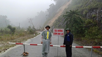
On September 24, the storm is likely to weaken, and in the early morning of September 25, the storm will pass the Leizhou peninsula (China) and move into the Gulf of Tonkin with a strong intensity of level 12-14, gusting to level 15-16; it is forecasted that on September 25, the storm will move into our mainland (focusing on the area from Quang Ninh to Ha Tinh).
According to the assessment of the National Center for Hydro-Meteorological Forecasting, in the past 2-3 days, most models and international and Vietnamese storm forecasting centers have simulated this as a storm with a very wide circulation, very strong intensity when operating in the East Sea, reaching super typhoon level, strongest in the period of September 22-23. In particular, the maximum intensity of storm No. 9 is forecasted by the Japanese meteorological agency to reach 195 km/h (level 16), gusts above level 17, the Chinese meteorological agency forecasts it can reach 223 km/h (above level 17), gusts above level 17, the Hong Kong (China) meteorological agency forecasts 240 km/h (above level 17), gusts above level 17.
Forecast of 2 scenarios of storm RAGASA
On September 24, when moving to the sea area south of Guangdong province (China), due to the storm's northern circulation being affected by terrain friction, storm No. 9 is forecast to weaken and when entering the Gulf of Tonkin, the storm's intensity will decrease by 2-4 levels compared to when it was still offshore.
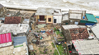
However, it should be noted that a worse scenario is still possible, that is, when entering the East Sea, the storm will move mainly in a westerly direction, the lower the storm trajectory, the less the storm intensity will be reduced, the impact of strong winds and large waves in the Gulf of Tonkin will be higher. With this scenario, in the Northern coast, the Central coastal area from Thanh Hoa to Hue will have very strong storm winds, accompanied by heavy rain.
In addition, in the north, there is currently an early-season cold air mass moving towards our country. The interaction of cold air with storms in the coming days will make the trajectory and intensity of storm RAGASA more complicated, and long-term forecasts (after 3 days) currently have a large dispersion.
Thus, with the above 2 scenarios, only 50-100 km North or South deviation, the storm intensity when approaching the coast of Vietnam and the impact consequences will also be very different, so it is necessary to continue updating forecasts according to monitoring data and subsequent analysis.
Beware of thunderstorms and tornadoes when the storm is 300-400 km from the mainland; beach areas from Quang Ninh to Hue City and Da Nang need to pay attention to thunderstorms due to the impact of circulation in the front part of the storm.
Thu Cuc
Source: https://baochinhphu.vn/bao-ragasa-hoan-luu-rat-rong-sap-dat-cap-sieu-bao-102250922072415893.htm


![[Photo] National Assembly Chairman Tran Thanh Man chairs the 8th Conference of full-time National Assembly deputies](https://vphoto.vietnam.vn/thumb/1200x675/vietnam/resource/IMAGE/2025/9/29/2c21459bc38d44ffaacd679ab9a0477c)
![[Photo] Many streets in Hanoi were flooded due to the effects of storm Bualoi](https://vphoto.vietnam.vn/thumb/1200x675/vietnam/resource/IMAGE/2025/9/29/18b658aa0fa2495c927ade4bbe0096df)
![[Photo] General Secretary To Lam receives US Ambassador to Vietnam Marc Knapper](https://vphoto.vietnam.vn/thumb/1200x675/vietnam/resource/IMAGE/2025/9/29/c8fd0761aa184da7814aee57d87c49b3)
![[Photo] General Secretary To Lam attends the ceremony to celebrate the 80th anniversary of the post and telecommunications sector and the 66th anniversary of the science and technology sector.](https://vphoto.vietnam.vn/thumb/1200x675/vietnam/resource/IMAGE/2025/9/29/8e86b39b8fe44121a2b14a031f4cef46)


Comment (0)