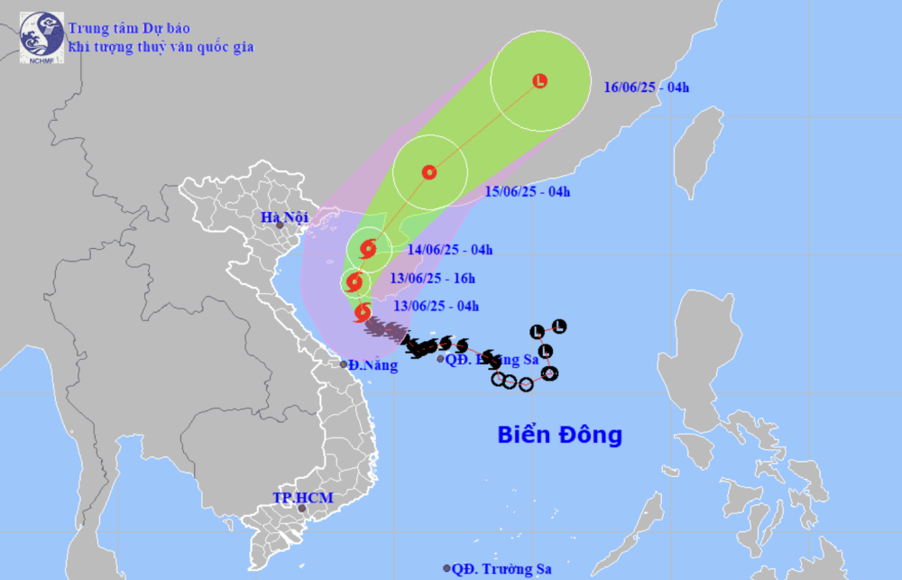
Forecast of location and direction of storm No. 1 at 4:00 a.m. on June 13 (Photo: NCHMF)
According to the National Center for Hydro-Meteorological Forecasting this morning (June 13), the intensity of storm No. 1 has increased by 1 level, from level 9 to level 10, with gusts of level 13.
At 4am this morning, the eye of storm No. 1 was in the sea south of Hainan Island (China).
Forecast from this morning to this afternoon (next 12 hours), the storm will move north-northwest, making landfall on the western coast of Hainan.
At 4:00 p.m. this afternoon, the storm center was right on the west coast of Hainan Island, with a level 10 intensity and gusts of level 13.
This evening and tonight, the storm is likely to turn north-northeast, running along the western coast of Hainan Island, towards the Leizhou Peninsula (China).
At 4am tomorrow morning, the storm center will be in the eastern sea area of the northern Gulf of Tonkin, with a storm intensity of level 9-10, gusting to level 13.
During tomorrow day and night, the storm will enter the Leizhou Peninsula, then move deep into southern China and gradually weaken into a tropical depression in the southwestern area of Guangdong Province (China).
Due to the influence of the storm, the northwest of the North East Sea, the offshore sea from Quang Tri to Quang Nam has strong winds of level 6-8, near the storm's eye level 9-10, gusts of level 13, waves 3-5m high, near the storm's eye 4-6m, very rough seas.
The Gulf of Tonkin has strong winds of level 6-7, near the storm's eye level 8-10, gusts of level 13, waves 2-4m high, especially in the east 3-5m, very rough seas.
Ships operating in the above mentioned dangerous areas are likely to be affected by storms, whirlwinds, strong winds and large waves.
Due to the impact of high tides and storm surges, provinces from Hai Phong to Nghe An are likely to experience high sea levels (Hon Dau: 3.9m, Hon Ngu: 2.8m) causing localized flooding in some low-lying coastal and river mouth areas between 5-7pm on June 13 and 14.
Early this morning and today, the area from Quang Binh to Hue has heavy to very heavy rain with common rainfall of 50-130mm, in some places over 250mm.
The southern Nghe An and Ha Tinh areas, from Da Nang to Quang Nam and Kon Tum, will have moderate to heavy rain, locally very heavy rain and thunderstorms with common rainfall of 20-50mm, in some places over 120mm./.
Floods on the river in Quang Tri are rising. Last night, due to the influence of storm No. 1, in the area from Nghe An to Quang Nam there was moderate to heavy rain, especially in the area from Quang Binh to Da Nang there was heavy to very heavy rain. Rainfall from 7pm last night to 3am this morning was over 170mm in some places such as Hai Lam (Quang Tri) 175mm, Hong Van (Hue) 173mm, Phuc Trach (Quang Binh) 172mm,... According to data from the disaster monitoring system at 4am this morning, the flood on the Huong River (Hue) is at 2.06m, about 0.06m above alert level 2. Bo River (Hue) reached peak level 3 (4.5m) at 2am and is slowly decreasing. Thach Han River (Quang Tri) is rising, at 4am at 5.66m, about 0.44m below BĐ3 signal. Hieu River in Dong Ha is rising and at 2.64m, about 0.36m below BĐ2. Kien Giang River (Quang Binh) at Le Thuy is maintaining at 2.6m, about 0.1m below BĐ3 level. High risk of landslides in mountainous areas, riverbank landslides, localized flooding in low-lying areas along rivers and urban areas in provinces from Quang Binh to Hue. |
According to Tuoi Tre Newspaper
Source: https://tuoitre.vn/bao-so-1-tang-len-cap-10-giat-cap-13-20250613000947901.htm
Source: https://baolongan.vn/bao-so-1-tang-len-cap-10-giat-cap-13-a196997.html


Comment (0)