
 |
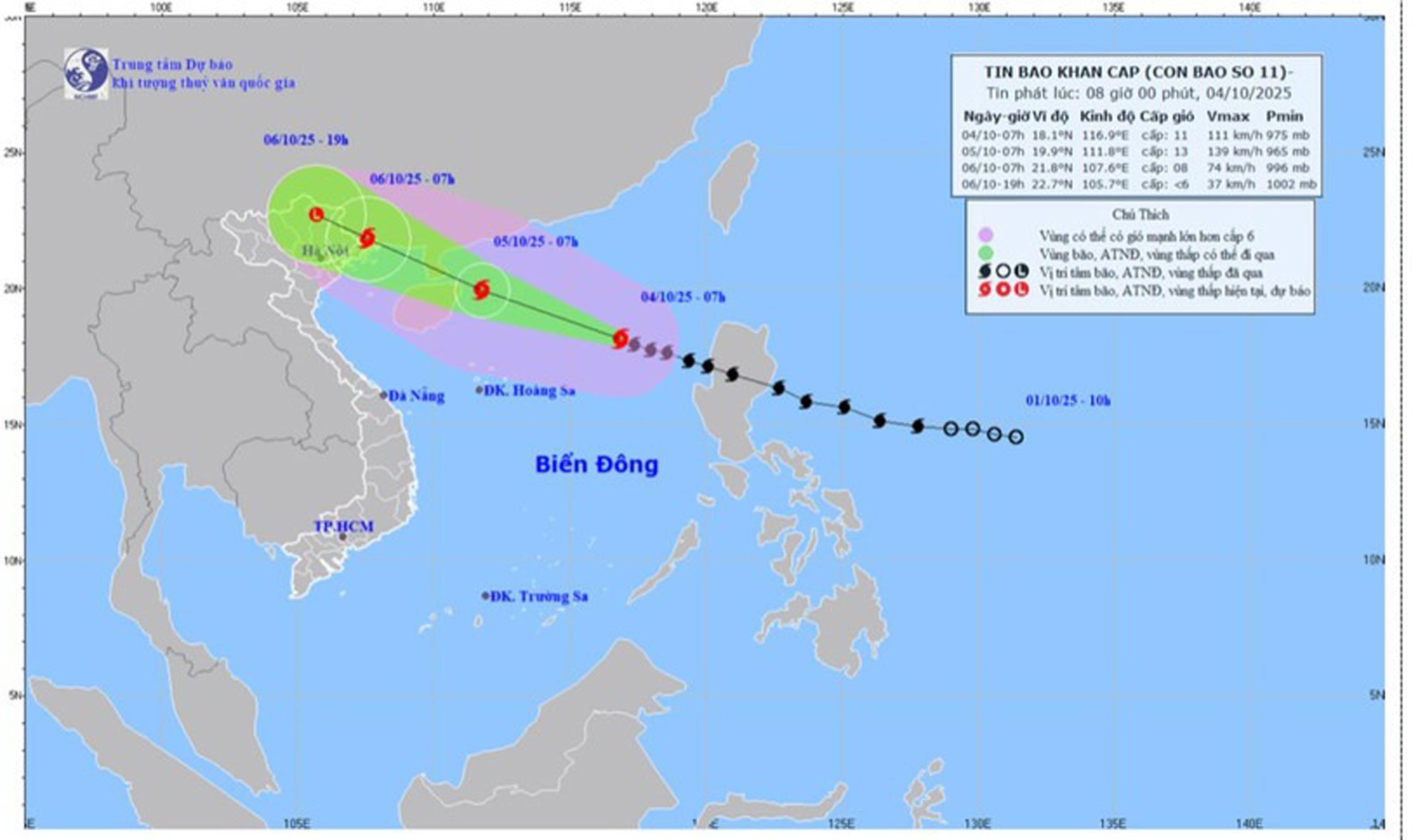
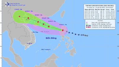
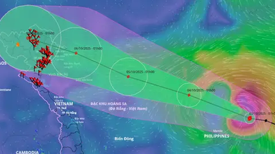
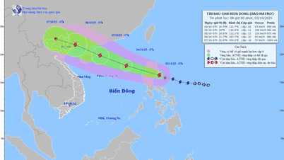
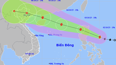
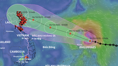
| Forecast map of storm No. 11's trajectory and intensity released at 8:00 a.m. on October 4. |
The strongest wind near the storm center is level 11 (103-117km/h), gusting to level 14.
Moving west northwest, speed about 25km/h.
Storm forecast (in the next 24 to 60 hours):
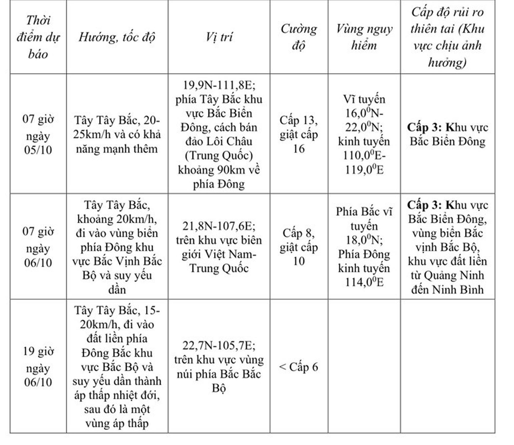 |
At sea, in the northern East Sea, there are strong winds of level 8-10, near the storm center level 11-13, gusts of level 16, waves 4-6m high, near the storm center 6-8m, very rough seas (extremely destructive, extremely strong waves. Sinking large tonnage ships).
From the afternoon of October 5, the sea area east of the northern Gulf of Tonkin (including Bach Long Vi special zone) has winds gradually increasing to level 6-7, then increasing to level 8-9. From the evening of October 5, the northern Gulf of Tonkin (including Bach Long Vi special zone, Van Don, Co To, Cat Hai and Hon Dau island) has winds gradually increasing to level 8-9, waves 2-4m high, the area near the storm center has levels 10-11, gusts of level 14, waves 3-5m high, rough seas (rough seas, very dangerous for ships).
Coastal areas and islands in Quang Ninh - Hai Phong provinces will have storm surges of 0.4-0.6m. Beware of flooding in low-lying coastal areas and river mouths due to surges and big waves from the afternoon and evening of October 5.
Weather warning at sea, coastal mainland during storm is extremely dangerous, unsafe for any vehicle, construction operating in the danger zone such as: cruise ships, passenger ships, transport ships, cages, rafts, aquaculture areas, dykes, embankments, coastal routes. Vehicles are highly likely to capsize, be destroyed; flooded due to strong winds, big waves and rising sea levels.
On land, from the night of October 5th on land from Quang Ninh to Ninh Binh, winds will gradually increase to level 6-7, near the storm center, level 8-9 (winds can break tree branches, blow roofs off houses, causing damage to houses. Cannot go against the wind). Inland areas in the northeast of the country, winds will be strong at level 5, in some places level 6, gusting to level 7-8.
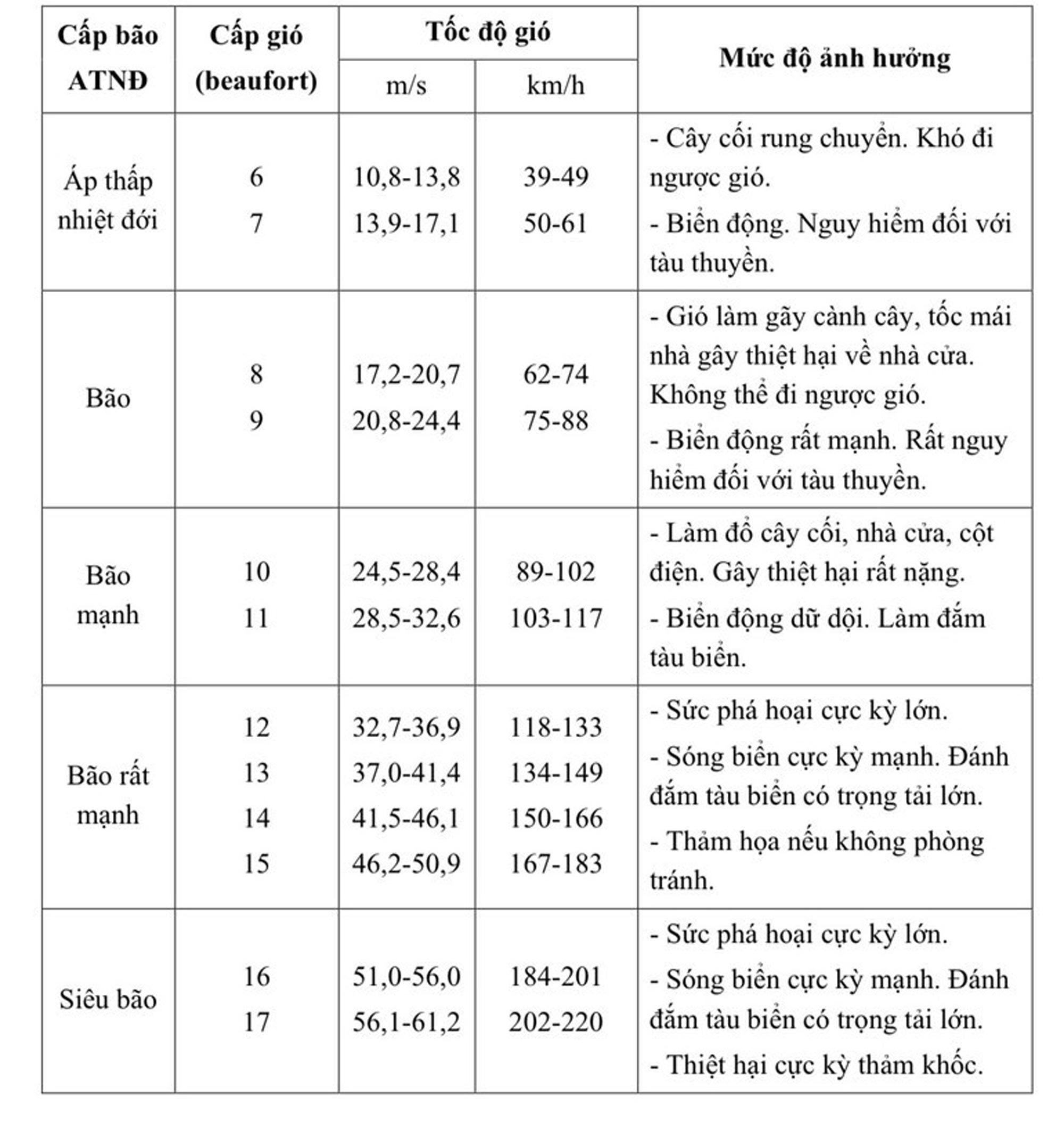
The level of impact according to the wind level of the storm
 |
In Hanoi area, from early morning of October 6 to the end of October 7, there will be moderate rain, heavy rain, and locally very heavy rain with common rainfall of 70-150mm, and locally over 250mm.
Source: nhandan.vn
Source: https://baodongnai.com.vn/co-the-ban-quan-tam/202510/bao-so-11-matmo-giat-cap-14-o-bac-bien-dong-d330637/

![[Photo] Solemn opening of the 8th Congress of the Central Public Security Party Committee, term 2025-2030](https://vphoto.vietnam.vn/thumb/1200x675/vietnam/resource/IMAGE/2025/10/4/f3b00fb779f44979809441a4dac5c7df)


![[Photo] General Secretary To Lam attends the 8th Congress of the Central Public Security Party Committee](https://vphoto.vietnam.vn/thumb/1200x675/vietnam/resource/IMAGE/2025/10/4/79fadf490f674dc483794f2d955f6045)


![[Infographic] Notable numbers after 3 months of "reorganizing the country"](https://vphoto.vietnam.vn/thumb/1200x675/vietnam/resource/IMAGE/2025/10/4/ce8bb72c722348e09e942d04f0dd9729)
![[Photo] Students of Binh Minh Primary School enjoy the full moon festival, receiving the joys of childhood](https://vphoto.vietnam.vn/thumb/1200x675/vietnam/resource/IMAGE/2025/10/3/8cf8abef22fe4471be400a818912cb85)


Comment (0)