
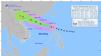
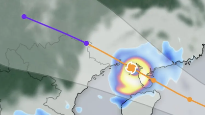
According to the National Center for Hydro-Meteorological Forecasting, this morning, October 3, the center of storm Matmo was at about 16.3 degrees North latitude and 122.7 degrees East longitude, in the sea east of Luzon Island, Philippines. The strongest wind near the center of the storm at 7:00 a.m. this morning was level 9-10, or 75-102 km/h, gusting to level 13, moving in the West Northwest direction at a speed of about 25 km/h.

The National Center for Hydro-Meteorological Forecasting predicts that tomorrow morning, October 4, the eye of the storm will enter the East Sea, about 750km southeast of China's Leizhou Peninsula. When entering the East Sea, the storm is likely to strengthen, reaching level 10-11, gusting to level 14. By the morning of October 5, the storm will continue to move in a West-Northwest direction at a speed of 20-25km/hour, approaching the Leizhou Peninsula, with a strength of level 12, gusting to level 15.
By the morning of October 6, the storm entered the northern Gulf of Tonkin, with a level 10 intensity, gusting to level 13, and showing signs of weakening. Vietnamese meteorological experts believe that currently, storm No. 11 (Matmo) has similar characteristics to the recent storm No. 9.

International forecast models also recorded similar developments. The Japan Meteorological Agency (JMA) and the Joint Typhoon Warning Center (JTWC) as well as the GFS global model all forecast that after passing Luzon Island, Typhoon Matmo will strengthen when entering the East Sea (from the evening of October 3, Vietnam time) thanks to high sea temperatures and favorable atmospheric conditions. The Philippine Meteorological Agency (PAGASA) upgraded Matmo to a strong tropical storm on the morning of October 3, and issued warnings of strong winds and heavy rains for the northern region of the country.

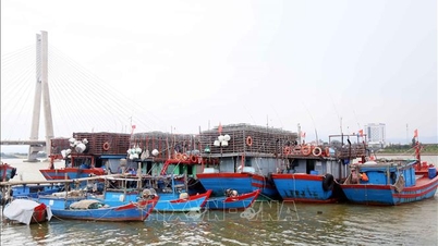
According to the National Center for Hydro-Meteorological Forecasting of Vietnam, in the East Sea, from noon and afternoon of October 3, the Northeast East Sea wind will gradually increase to level 6-7, then increase to level 8-9, the area near the storm's center will be strong at level 10-11, gusting to level 13, waves 4-6m high, and the sea will be very rough.
From October 4 to 5, the northern waters of the East Sea are likely to experience strong winds of level 11-12, gusting to level 15. Ships operating in the dangerous area are at risk of being affected by storms, whirlwinds, strong winds and large waves.
Source: https://www.sggp.org.vn/dem-nay-3-10-tam-bao-matmo-vao-bien-dong-post816089.html
![[Photo] Students of Binh Minh Primary School enjoy the full moon festival, receiving the joys of childhood](https://vphoto.vietnam.vn/thumb/1200x675/vietnam/resource/IMAGE/2025/10/3/8cf8abef22fe4471be400a818912cb85)


![[Photo] Prime Minister Pham Minh Chinh chairs meeting to deploy overcoming consequences of storm No. 10](https://vphoto.vietnam.vn/thumb/1200x675/vietnam/resource/IMAGE/2025/10/3/544f420dcc844463898fcbef46247d16)


Comment (0)