
 |
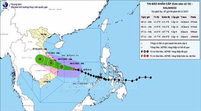
| The trajectory of Typhoon No. 13 at 5:00 AM on November 6th. Photo: VNA |
At 8:00 AM on November 6th, the typhoon's center was located at approximately 13.2 degrees North latitude and 112.3 degrees East longitude, about 310km east-southeast of Quy Nhon. The strongest winds near the center of the typhoon reached level 14 (150-166 km/h), with gusts up to level 17; it was moving west-northwest at a speed of approximately 30 km/h.
As of 7 PM on November 6th, the storm was located at approximately 14.0 degrees North latitude and 109.4 degrees East longitude, over the coastal area of Quang Ngai - Dak Lak , with wind speeds of level 13-14, gusts up to level 17, and a level 4 natural disaster risk in the central East Sea, the sea area from Quang Ngai to Dak Lak (including Ly Son special zone), and the eastern mainland from Quang Ngai to Gia Lai.
The western part of the South China Sea, the sea area from Quang Ngai to Dak Lak (including the Ly Son special economic zone); and the eastern mainland area from Quang Ngai to Gia Lai have a natural disaster risk level of 4.
The sea area from southern Quang Tri to Da Nang City (including Cu Lao Cham Island) and Khanh Hoa; the mainland from southern Quang Tri to Da Nang City, the eastern part of Dak Lak province and the northern part of Khanh Hoa province have a level 3 natural disaster risk.
Forecasts indicate that by 7:00 AM on November 7th, the storm will move in a west-northwest direction, making landfall and weakening into a tropical depression over southern Laos, with wind speeds decreasing to level 7, gusting to level 9. The sea area from Quang Ngai to Dak Lak (including Ly Son special zone); and the eastern mainland area from Quang Ngai to Gia Lai will have a level 4 natural disaster risk.
The sea area from southern Quang Tri to Da Nang City (including Cu Lao Cham island) and Khanh Hoa; the mainland from southern Quang Tri to Da Nang City, the western part of Quang Ngai and Gia Lai provinces, the eastern part of Dak Lak province and the northern part of Khanh Hoa province have a level 3 natural disaster risk.
By 7 PM on the same day, the tropical depression over eastern Thailand moved inland, weakening into a low-pressure area with wind speeds below level 6.
Warning of strong winds, high waves, and storm surge: In the South China Sea, the central area will experience strong winds of force 8-11, near the storm's center winds of force 12-14, gusts up to force 17, waves 5-7m high, near the storm's center waves 8-10m high, and extremely rough seas. The sea area from southern Quang Tri to Khanh Hoa (including Ly Son special zone and Cu Lao Cham island) will experience gradually increasing winds of force 6-7, then increasing to force 8-11, waves 3-6m high; near the storm's center winds of force 12-14, gusts up to force 17, waves 7-9m high.
The coastal area from southern Quang Tri to Dak Lak is likely to experience storm surges of 0.4 - 0.8m, posing a risk of flooding in low-lying areas, wave breaches, coastal erosion, and slowed flood drainage. All boats and aquaculture farms in the danger zone will be severely affected by thunderstorms, tornadoes, strong winds, and high waves.
On land, from the afternoon of November 6th, the area from southern Da Nang to Dak Lak will experience gradually increasing winds of force 6-7, then increasing to force 8-9; in the area near the storm's center, winds will reach force 10-12 (with the focus on eastern Quang Ngai - Gia Lai), gusting to force 14-15. The area from southern Quang Tri to northern Khanh Hoa will experience strong winds of force 6-7, gusting to force 8-9. Heavy rain will fall over a wide area.
From November 6th to 7th, the area from Da Nang to Dak Lak experienced very heavy rainfall, with common amounts of 200-400mm, and localized areas exceeding 600mm; the area from southern Quang Tri to Hue, Khanh Hoa, and Lam Dong received 150-300mm of rain, with some places exceeding 450mm. From November 7th to 8th, the rain spread to northern Quang Tri to Thanh Hoa, with common amounts of 50-150mm, and some places exceeding 200mm.
The center warns of a high risk of heavy rainfall exceeding 200mm/3 hours, tornadoes, and strong gusts of wind before and during the storm's landfall. A level 4 disaster warning has been issued for the central East Sea area and the Quang Ngai - Gia Lai region; and a level 3 warning for the sea area from southern Quang Tri to Da Nang and Khanh Hoa.
Source: https://baothainguyen.vn/tai-nguyen-moi-truong/202511/bao-so-13-giat-cap-17-cach-quy-nhon-khoang-310km-e004e27/


![[Photo] General Secretary and President To Lam presides over the meeting to approve the draft report on the results of the second inspection by the Politburo of the Standing Committee of the Hanoi City Party Committee.](https://vphoto.vietnam.vn/thumb/1200x675/vietnam/resource/IMAGE/2026/05/26/1779789811432_a2-bnd-4430-9620-jpg.webp)


Comment (0)