
 |
| (Photo: National Center for Hydro-Meteorological Forecasting) |
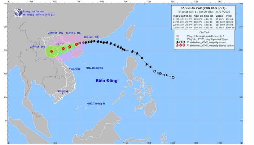
According to the National Center for Hydro-Meteorological Forecasting, this morning (July 21), storm No. 3 passed the northern area of Leizhou Peninsula (China), entering the northern part of the Gulf of Tonkin.
At 10:00 a.m., the center of the storm was at approximately 21.2 degrees north latitude; 109.6 degrees east longitude, approximately 190km from Quang Ninh, 310km east of Hai Phong ; approximately 340km from Hung Yen, approximately 360km east-northeast of Ninh Binh. The strongest wind near the center of the storm was level 9 (75-88km/h), gusting to level 11; moving west-southwest at a speed of 10-15km/h.
Due to the influence of the storm, the northwestern sea area of the northern East Sea has strong winds of level 7-8, gusts of level 10; waves 3-5m high, rough seas. The northern sea area of the Gulf of Tonkin (including the special zones of Bach Long Vi, Co To, Van Don, Cat Hai, Hon Dau island) has strong winds of level 6-7, then increasing to level 8-9, the area near the storm's eye has winds of level 10-11, gusts of level 14, waves 2-4m high, the area near the storm's eye has winds of 4-6m, rough seas. The southern sea area of the Gulf of Tonkin (including Hon Ngu island) has winds gradually increasing to level 6-7, the area near the storm's eye has winds of level 8-9, gusts of level 11, waves 2-4m high, rough seas.
The coastal areas of Hung Yen - Quang Ninh have storm surges of 0.5-1m high. Water levels in Ba Lat ( Hung Yen ) are 2.4-2.6m high, Hon Dau (Hai Phong) are 3.9-4.3m high, Cua Ong (Quang Ninh) are 4.6-5m high and Tra Co (Quang Ninh) are 3.6-4m high. There is a high risk of flooding in coastal areas and river mouths on the afternoon of July 22.
The meteorological agency warns that the weather at sea and in coastal areas during the storm is extremely dangerous and unsafe for any vehicles or structures operating in the danger zone such as: cruise ships, passenger ships, transport ships, cages, rafts, aquaculture areas, dykes, embankments, coastal routes. Vehicles are at high risk of capsizing, destruction, and flooding due to strong winds, storms, whirlwinds, large waves, and rising sea levels.
On land, from the evening and night of July 21, coastal areas from Quang Ninh to Nghe An will have winds gradually increasing to level 7-9, near the storm center level 10-11, gusting to level 14; inland areas of the provinces and cities of Hai Phong, Hung Yen, Ninh Binh and Thanh Hoa, strong winds of level 6, gusting to level 7-8.
Winds of level 10-11 can knock down trees, electric poles, and rip off roofs, causing very serious damage.
Source: https://huengaynay.vn/chinh-tri-xa-hoi/theo-dong-thoi-su/bao-so-3-dang-tien-vao-vinh-bac-bo-cach-quang-ninh-khoang-190km-bien-dong-rat-manh-155888.html


![[Photo] National Assembly Chairman Tran Thanh Man visits Vietnamese Heroic Mother Ta Thi Tran](https://vphoto.vietnam.vn/thumb/1200x675/vietnam/resource/IMAGE/2025/7/20/765c0bd057dd44ad83ab89fe0255b783)


Comment (0)