
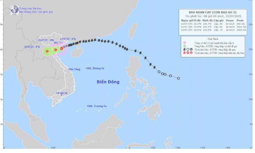
The strongest wind near the storm center is level 9 (75-88km/h), gusting to level 12, moving in the West Southwest direction at a speed of about 15km/h.
Due to the impact of storm No. 3, in Bach Long Vi special zone, there were strong winds of level 10, gusting to level 12. Co To special zone had strong winds of level 8, gusting to level 11. Cat Ba (Cat Hai special zone) had strong winds of level 6, gusting to level 8. Cua Ong had strong winds of level 9, gusting to level 12. Bai Chay had strong winds of level 8, gusting to level 9. Quang Ha had strong winds of level 8. Tien Yen had strong winds of level 7, gusting to level 9. Thai Binh station had strong winds of level 7, gusting to level 8. Mong Cai had strong winds of level 6, gusting to level 9. Phu Lien had strong winds of level 6, gusting to level 8,...
Forecast of storm/tropical depression (in the next 12 to 24 hours):

The northern sea area of the Gulf of Tonkin (including the special zones of Bach Long Vi, Co To, Van Don, Cat Hai, Hon Dau island) has strong winds of level 6-7, near the eye of the storm level 8-9, gusts of level 12; waves 2-4m high, near the eye of the storm 3-5m, very rough seas. The southern sea area of the Gulf of Tonkin (including Hon Ngu island) has strong winds of level 6-7, near the eye of the storm level 8, gusts of level 11, waves 2-4m high; rough seas.
On land, coastal areas from Quang Ninh to Nghe An have strong winds of level 6-7, near the storm center level 8-9, gusting to level 12; inland areas of the provinces/cities of Hai Phong, Hung Yen, Bac Ninh, Hanoi , Ninh Binh and Thanh Hoa have strong winds of level 6, gusting to level 7-8. Level 9 winds can break tree branches, blow off roofs, causing damage to houses.
From July 22 to July 23, in the Northern Delta region, Thanh Hoa and Nghe An, there will be heavy to very heavy rain and thunderstorms with common rainfall of 100-200mm, locally over 300mm; other places in the Northern region and Ha Tinh will have moderate rain, heavy rain, locally very heavy rain and thunderstorms with common rainfall of 50-100mm, locally over 150mm.
Warning of risk of heavy rain (>150mm/3 hours). Heavy rain in a short period of time can cause flash floods, landslides in mountainous areas, and flooding in low-lying areas.
Due to the extremely dangerous weather at sea and coastal areas during storms, it is unsafe for any vehicles or structures operating in the danger zone such as: cruise ships, passenger ships, transport ships, cages, rafts, aquaculture areas, dykes, embankments, coastal routes. Vehicles are highly likely to capsize, be destroyed, or be flooded due to strong winds, storms, whirlwinds, large waves, and rising sea levels.
Source: https://nhandan.vn/bao-so-3-giat-cap-12-vung-gan-tam-bao-co-song-bien-cao-3-5m-post895362.html


Comment (0)