
Current location and intensity
At 7:00 a.m. on July 21, the center of storm No. 3 was determined to be at 21.3°N; 109.9°E, about 220km east of the Quang Ninh- Hai Phong area. The storm currently has the strongest wind of level 9 (75-88km/h), gusting to level 11, moving in the West-Southwest direction at a speed of 15-20km/h.
Early this morning, storm No. 3 was in the northern Leizhou Peninsula (China) before entering the Gulf of Tonkin.
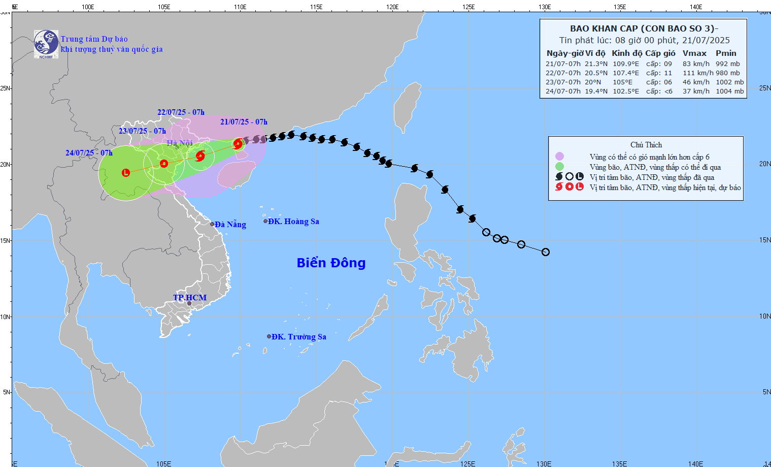
Forecast for the coming days
By 7am on July 22, storm No. 3 is expected to move west-southwest at a speed of 10-15km/h and is likely to strengthen. At this time, the storm will be in the Gulf of Tonkin with a storm intensity of level 10-11, gusting to level 14.
Tomorrow (July 22), storm No. 3 will approach the shore and make landfall in the area from South Hai Phong to North Thanh Hoa with a level 9-10 intensity, gusting to 13.
At 7:00 a.m. on July 23, the storm continued to move in the West Southwest direction, at a speed of 10-15 km/h and gradually weakened into a tropical depression over the mainland of Thanh Hoa - Nghe An provinces.
By 7:00 a.m. on July 24, storm No. 3 will gradually weaken into a low pressure area over the mainland of upper Laos.
Warning of serious impact on the sea
Due to the influence of storm No. 3, the northwestern sea area of the North East Sea has strong winds of level 7-8, gusting to level 10 with waves 3.0-5.0m high, and rough seas.
The northern Gulf of Tonkin (including the special zones of Bach Long Vi, Co To, Van Don, Cat Hai, Hon Dau island) has strong winds of level 6-7, then increasing to level 8-9, the area near the storm's eye has level 10-11, gusting to level 14. Waves are 2.0-4.0m high, the area near the storm's eye is 3.0-5.0m high, the sea is very rough.
The sea area in the southern Gulf of Tonkin (including Hon Ngu Island) has winds gradually increasing to level 6-7, near the storm center level 8-9, gusting to level 11, waves 2.0-4.0m high, very rough seas.
Red Safety Alert
The coastal areas of Hung Yen-Quang Ninh have storm surges of 0.5-1.0m. The water level is forecast to be 3.7-4.1m at Hon Dau (Hai Phong), 4.4-4.8m at Cua Ong (Quang Ninh) and 3.6-4.0m at Tra Co (Quang Ninh). There is a high risk of flooding in coastal areas and river mouths on the afternoon of July 22.
The meteorological agency warns that the weather at sea and in coastal areas during the storm is extremely dangerous, unsafe for any means of transport or construction operating in the danger zone such as cruise ships, passenger ships, transport ships, cages, aquaculture areas, dykes, coastal routes. Vehicles are highly likely to be capsized, destroyed, flooded due to strong winds, storms, whirlwinds, large waves and rising sea levels.
From the evening and night of July 21, coastal areas from Quang Ninh to Nghe An will have winds gradually increasing to level 7-9, near the storm center level 10-11, gusting to level 14. Inland areas will have strong winds of level 6, gusting to level 7-8. Winds of level 10-11 can knock down trees, electric poles, and rip off roofs, causing very heavy damage.
From July 21 to July 23, the Northeast region, the Northern Delta, Thanh Hoa and Nghe An will have heavy to very heavy rain and thunderstorms with common rainfall of 200-350mm, locally over 600mm. Other places in the Northern region and Ha Tinh will have moderate to heavy rain, locally very heavy rain and thunderstorms with common rainfall of 100-200mm, locally over 300mm.
The Meteorological Agency warns of the risk of heavy rain (>150mm/3h). Heavy rain in a short period of time can cause flash floods, landslides in mountainous areas, and flooding in low-lying areas.
People and relevant units need to closely monitor updated news and strictly implement storm prevention measures as directed by local authorities.
Source: https://baonghean.vn/bao-so-3-wipha-chi-con-cach-mien-bac-viet-nam-hon-200km-trong-tam-do-bo-se-vao-dau-10302768.html


![[Photo] National Assembly Chairman Tran Thanh Man visits Vietnamese Heroic Mother Ta Thi Tran](https://vphoto.vietnam.vn/thumb/1200x675/vietnam/resource/IMAGE/2025/7/20/765c0bd057dd44ad83ab89fe0255b783)


Comment (0)