
 |
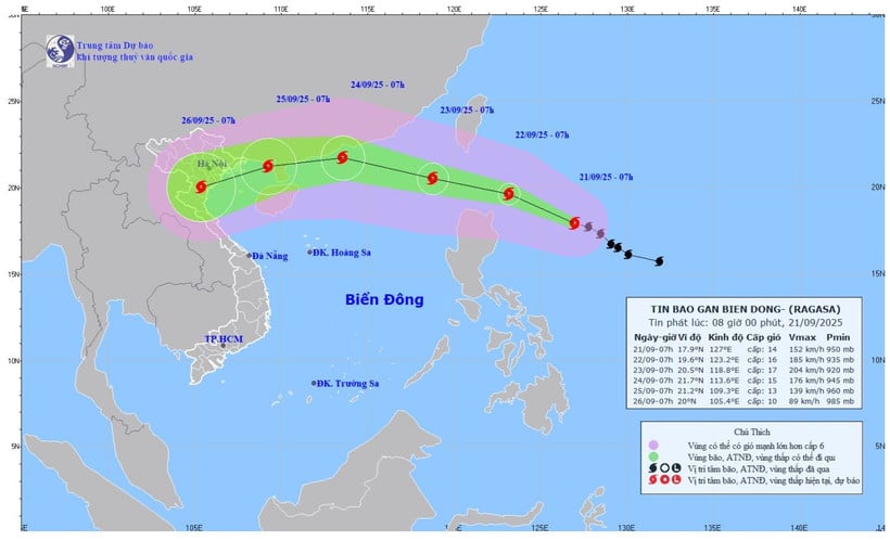
| Forecast map of the trajectory and intensity of storm No. 9 issued at 8:00 a.m. on September 21, 2025. (Photo: National Center for Hydro-Meteorological Forecasting) |
At 7:00 a.m. on September 21, the center of storm No. 9 (Ragasa) was at about 17.9 degrees north latitude, 127.0 degrees east longitude, about 520 km east of Luzon Island (Philippines). The strongest wind near the center of the storm was level 14 (150 to 166 km/h), gusting to level 17. Moving west-northwest at a speed of about 15 km/h.
At 7:00 a.m. on September 22, storm No. 9 was moving west-northwest at a speed of about 15-20 km/hour and was likely to strengthen further; the center of the storm was at about 19.6 degrees north latitude, 123.2 degrees east longitude; about 180 km north-northeast of Luzon Island (Philippines). The strongest wind near the center of the storm was at level 16, gusting to over level 17.
At 7:00 a.m. on September 23, the storm moved west-northwest at a speed of 15 to 20 km/h, entering the East Sea; the center of the storm was at about 20.5 degrees north latitude, 118.8 degrees east longitude, in the sea area east of the northern East Sea, storm strength level 16 to 17, gusting above level 17. Disaster risk level: Level 4; affected area: sea area east of the northern East Sea.
At 7:00 a.m. on September 24, the center of the storm was at about 21.7 degrees north latitude and 113.6 degrees east longitude. The storm moved west-northwest at a speed of 20 to 25 km/hour, over the sea of Guangdong province (China). The strongest wind near the center of the storm was level 15, gusting to over level 17. Disaster risk level: Level 4; affected area: northern East Sea.
From the next 72 to 120 hours, the storm moved in the west-southwest direction, about 20km per hour, gradually weakening.
Due to the influence of the storm, at sea, from September 22, the sea area east of the northern East Sea will gradually increase to level 8 to 9, then increase to level 10 to 14, the area near the storm center will have level 15 to 17, gusts above level 17, waves over 10m high; the sea will be very rough.
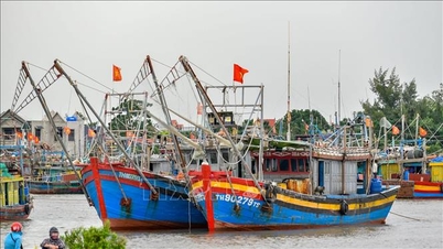
The meteorological agency warns that ships operating in the above-mentioned dangerous areas are likely to be affected by storms, whirlwinds, strong winds, and large waves.
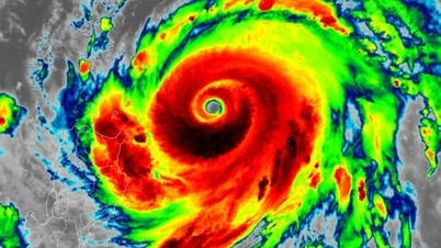
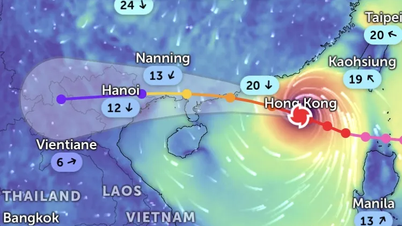
The National Center for Hydro-Meteorological Forecasting said that Ragasa storm is active and rapidly intensifying, possibly reaching super typhoon level. Storm No. 9 is likely to affect the mainland of Vietnam between September 24 and 25, causing strong winds and heavy rains in the Northern region and the Central provinces from Thanh Hoa to Hue.
The meteorological agency forecasts that after entering the East Sea, the movement of storm No. 9 will remain unpredictable due to the influence of many factors.
People's Newspaper
Source: https://baodongnai.com.vn/xa-hoi/202509/bao-so-9-ragasa-tang-cap-nhanh-co-kha-nang-thanh-sieu-bao-a2e04a2/
![[Photo] Prime Minister Pham Minh Chinh chairs the 14th meeting of the Steering Committee on IUU](https://vphoto.vietnam.vn/thumb/1200x675/vietnam/resource/IMAGE/2025/9/23/a5244e94b6dd49b3b52bbb92201c6986)
![[Photo] General Secretary To Lam meets voters in Hanoi city](https://vphoto.vietnam.vn/thumb/1200x675/vietnam/resource/IMAGE/2025/9/23/d3d496df306d42528b1efa01c19b9c1f)
![[Photo] Editor-in-Chief of Nhan Dan Newspaper Le Quoc Minh received the working delegation of Pasaxon Newspaper](https://vphoto.vietnam.vn/thumb/1200x675/vietnam/resource/IMAGE/2025/9/23/da79369d8d2849318c3fe8e792f4ce16)


![[Photo] The 1st Congress of Party Delegates of Central Party Agencies, term 2025-2030, held a preparatory session.](https://vphoto.vietnam.vn/thumb/1200x675/vietnam/resource/IMAGE/2025/9/23/e3a8d2fea79943178d836016d81b4981)


Comment (0)