
On the afternoon of September 23, the National Center for Hydro-Meteorological Forecasting (Department of Hydro-Meteorology) urgently reported on the situation of super typhoon Ragasa (storm No. 9) to the National Civil Defense Steering Committee.
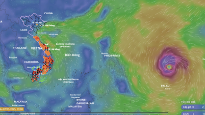
According to the Department of Hydrometeorology, this super typhoon is still active in the North East Sea with winds of level 16-17, gusting above level 17, and is considered the strongest super typhoon in the world , as of 2025.
A representative of the National Center for Hydro-Meteorological Forecasting said that storm No. 9 has a wide circulation, with a strong wind level 6 having a radius of up to 450km, level 10 about 200km and level 12 about 100km around the storm center. This is the reason why the North East Sea area has very rough seas, with waves over 10m high.

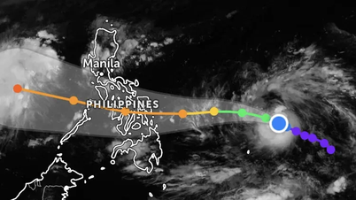
International and Vietnamese meteorological forecasting agencies are still in agreement that the super typhoon will continue to move rapidly in a West-Northwest direction, directly affecting the coast of Guangdong province (China), then passing north of Leizhou peninsula (China) and entering the Gulf of Tonkin.
From noon to afternoon of September 25, the eye of the storm is likely to make landfall in Vietnam, focusing from Quang Ninh to Hung Yen .
The National Center for Hydro-Meteorological Forecasting predicts that the storm will remain at a very strong level (level 15-16) until the morning of September 24, then gradually weaken when approaching mainland China due to terrain interactions and the impact of cold air from the North. However, when entering the Gulf of Tonkin, the storm will still be at level 11-12.

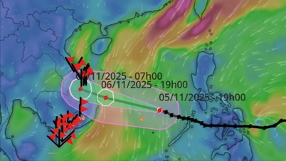
In a report sent to the National Civil Defense Steering Committee, the Department of Meteorology and Hydrology also informed: A new tropical depression has appeared in the East of the Philippines, which is forecast to strengthen into storm No. 10 and enter the East Sea from September 27.
At this point, forecast scenarios for this storm are still scattered, in which the scenario with the highest probability is that storm No. 10 will head towards the mainland of Central Vietnam.
Source: https://www.sggp.org.vn/sieu-bao-so-9-chua-vao-dat-lien-da-xuat-hien-ap-thap-nhiet-doi-post814352.html


![[Photo] Da Nang: Hundreds of people join hands to clean up a vital tourist route after storm No. 13](https://vphoto.vietnam.vn/thumb/1200x675/vietnam/resource/IMAGE/2025/11/07/1762491638903_image-3-1353-jpg.webp)


Comment (0)