

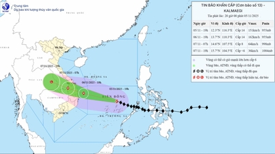
Forecast of location and direction of storm Kalmaegi at 4:00 p.m. on November 4 (Photo: VNDMS)
Mr. Mai Van Khiem, Director of the National Center for Hydro-Meteorological Forecasting, said this when informing about the development of storm Kalmaegi about to enter the East Sea on the afternoon of November 4.
Typhoon Kalmaegi strengthens after entering the East Sea
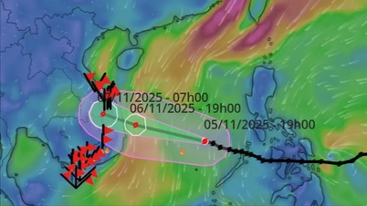
According to Mr. Khiem, it is forecasted that around the early morning of November 5, storm Kalmaegi will pass the Palawan archipelago (Philippines) and enter the East Sea, becoming the 13th storm this year.
"Through discussions with Japanese and Chinese forecasters and analysis and calculation results, the National Center for Hydro-Meteorological Forecasting assessed that after entering the East Sea, the intensity of storm Kalmaegi will increase.
It is forecasted that when it enters the Truong Sa special economic zone (November 6) and the sea off the coast of Da Nang - Khanh Hoa, the storm is likely to reach maximum intensity of level 14, gusting to level 16-17. Some models even predict that the storm may be stronger than level 14," said Mr. Khiem.
Mr. Khiem said current forecasts show that when the storm enters the central sea of our country, it is unlikely to weaken because the cold air is weakening and the sea surface temperature in the East Sea is relatively high.
Along with that, high humidity in the atmosphere, moderate wind shear and storm activity on the tropical convergence zone are favorable factors for the storm to develop in intensity.

Mr. Mai Van Khiem, Director of the National Center for Hydro-Meteorological Forecasting, information on storm Kalmaegi (Photo: C.TUỆ)
Ly Son Island is most susceptible to storms
Regarding the impact of storm Kalmaegi, Mr. Khiem said that from tomorrow afternoon (November 5), the central East Sea area (including the sea area north of Truong Sa special zone) will have winds gradually increasing to level 7-8, then increasing to level 9 on November.
The area near the storm center has level 12-14 winds, level 17 gusts, waves 5-7m high, the area near the storm center has waves 8-10m high.
From early morning of November 6, the sea area from Da Nang to Khanh Hoa (including Ly Son special zone) gradually increased wind to level 6-7, then increased to level 8/11, the area near the storm center had strong wind level 12-14, gusting to level 17.
Coastal areas from Hue to Dak Lak have waves 4-6m high, areas near the storm center have waves 6-8m high, and the sea is very rough.
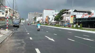
"Vessels operating at sea need to quickly move to safe shelters.
Along with that, we especially note that Ly Son special zone ( Quang Ngai ) is one of the first areas affected by dangerous storm winds, with the possibility of being affected by level 12 winds, even higher and gusting to level 14-15," Mr. Khiem emphasized.
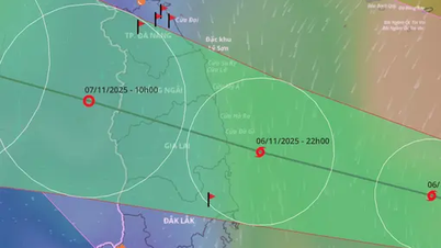
For the mainland, from the evening of November 6, on the mainland along the coast from southern Quang Tri to Da Nang, the east of Quang Ngai and Dak Lak provinces, the wind will gradually increase to level 6-7, then increase to level 8-9, the area near the storm's center will be strong at level 10-12, gusting to level 14-15 and the focus of strong winds is in the east of Quang Ngai - Dak Lak provinces.
From the evening and night of November 6, the western part of Quang Ngai and Gia Lai provinces will gradually increase the wind to level 6-7, the area near the storm's eye will increase to level 8, gusting to level 10.
Due to the influence of the wide storm circulation, it is necessary to guard against the risk of thunderstorms, tornadoes and strong gusts of wind both before and during the storm's landfall.
"This is a very strong storm with a wide circulation and strong winds that directly affect coastal provinces and cities from southern Quang Tri to Dak Lak.
The path and impact of storm Kalmaegi are likely to be similar to storm No. 12 (Damrey) that made landfall in the old Phu Yen - Khanh Hoa in 2017 and storm No. 9 (Molave) that made landfall in Quang Nam - Quang Ngai in 2020," Mr. Khiem added./.
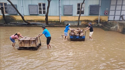
Storm Kalmaegi causes heavy rain from Da Nang to Dak Lak, some places over 600mm Regarding heavy rain, Mr. Khiem said that currently the cold air and east wind have weakened, so the rain is mainly due to the circulation of storm Kalmaegi. Specifically, from November 6 to 7, the area from Da Nang to Dak Lak will have very heavy rain with common rainfall of 200 - 400mm/period, locally over 600mm/period. The area from southern Quang Tri to Hue, Khanh Hoa and Lam Dong has heavy rain, locally very heavy rain with common rainfall of 150 - 300mm/period, locally over 450mm/period. From November 8, heavy rain in the above areas tends to decrease. From November 7 to 8, the area from northern Quang Tri to Thanh Hoa will have moderate rain, heavy rain, and locally very heavy rain with common rainfall of 50 - 150mm/period, and locally over 200mm/period. |
According to Tuoi Tre Newspaper
Source: https://tuoitre.vn/duong-di-va-tac-dong-bao-kalmaegi-tuong-tu-bao-damrey-nam-2017-20251104163426126.htm
Source: https://baolongan.vn/duong-di-va-tac-dong-bao-kalmaegi-tuong-tu-bao-damrey-nam-2017-a205812.html


![[Photo] Opening of the 14th Conference of the 13th Party Central Committee](https://vphoto.vietnam.vn/thumb/1200x675/vietnam/resource/IMAGE/2025/11/05/1762310995216_a5-bnd-5742-5255-jpg.webp)


![[Photo] Panorama of the Patriotic Emulation Congress of Nhan Dan Newspaper for the period 2025-2030](https://vphoto.vietnam.vn/thumb/1200x675/vietnam/resource/IMAGE/2025/11/04/1762252775462_ndo_br_dhthiduayeuncbaond-6125-jpg.webp)


Comment (0)