
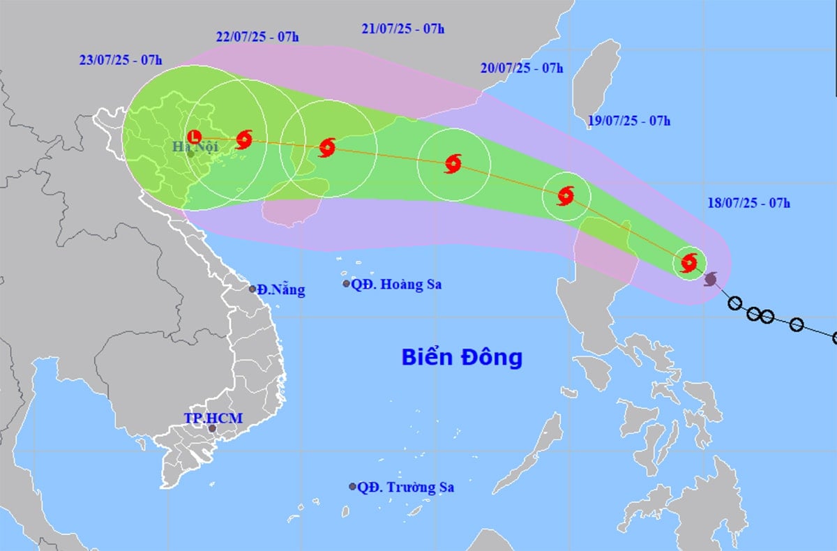
At 7:00 a.m. on July 18, Typhoon Wipha was in the sea east of Luzon Island (Philippines). The storm intensity was level 8 (62-74 km/h), gusting to level 10, moving northwest at a speed of about 20 km/h.
According to the meteorological agency, in the next 24 hours, the storm is forecast to move west-northwest at a speed of 20-25 km/h. Around tomorrow evening (July 19), storm Wipha will enter the East Sea, becoming storm number 3 in 2025.
Notably, after entering the East Sea, storm Wipha may continue to strengthen, reaching level 11-12 and is likely to directly affect mainland Vietnam around July 22.
On July 21-23, the Northern provinces and Thanh Hoa will experience heavy to very heavy rain.
From May until now, the North has had nearly 40 days of widespread rain divided into 9 periods, in which the shortest period only lasted for 1 day, the longest period lasted for a whole week.
Thanh Hoa to Hue and the South Central Coast also had 9 widespread showers and thunderstorms. In particular, during June 10-13, due to the influence of storm No. 1, the area from southern Ha Tinh to Quang Ngai recorded heavy to very heavy rain, with rainfall ranging from 250 - 500 mm, some places exceeding 600 mm.
During this period, the Central Highlands and the South experienced many days of showers and thunderstorms, including days of moderate to heavy rain over a wide area.
In addition, according to the meteorological agency's forecast, the ENSO phenomenon will continue in neutral conditions. From August to October 2025, ENSO is likely to maintain a neutral state with a probability of 70-90%.
From now until October, storms/tropical depressions operating in the East Sea and affecting our country may be at a level approximately equal to the average of many years (in the East Sea: 6.8 storms, making landfall: 2.8 storms).
Also during these 3 months, moderate and heavy rains are likely to occur in areas across the country. Rain will be concentrated in the North in August and September and in the Central region in September and October.
PVSource: https://baohaiphongplus.vn/bao-wipha-lien-tuc-manh-them-kha-nang-anh-huong-truc-tiep-den-dat-lien-trong-do-co-hai-phong-416627.html


![[Infographic] In 2025, 47 products will achieve national OCOP](https://vphoto.vietnam.vn/thumb/402x226/vietnam/resource/IMAGE/2025/7/16/5d672398b0744db3ab920e05db8e5b7d)


Comment (0)