
Regarding this issue, a reporter from the Natural Resources and Environment Newspaper had an interview with Dr. Pham Hong Tinh - Faculty of Environment - Hanoi University of Natural Resources and Environment about the causes and proposed mitigation measures.

PV: Could you tell us about the current level of degradation of RNM in Vietnam and the causes of the degradation?
Dr. Pham Hong Tinh: According to statistics in 2021 of the Ministry of Agriculture and Rural Development , our country has about more than 150,000 hectares of mangrove forests, accounting for about 3% of the total forest area in Vietnam, mainly concentrated in the southern coastal provinces, with about 55% in the Mekong Delta and about 23% in the Southeast.
Mangroves help provide products directly used for local people's livelihoods such as corn, wood, firewood, seafood and other ecosystem services, support coastal erosion control, water regulation, soil stabilization and carbon absorption... so degraded mangroves will lead to biodiversity loss, habitat imbalance and loss of spawning grounds for many aquatic species, destroy nutrient cycles and especially reduce ecosystem services...
Currently, due to the pressure of socio-economic development (urbanization, land use conversion, infrastructure construction, industrial zones, transportation, aquaculture, etc.) and climate change (CC), mangrove forests in Vietnam are being seriously threatened. In particular, mangrove degradation is occurring locally in many coastal areas from Mong Cai to Ca Mau and Kien Giang capes,...
PV: What is the basis for these assessments, sir?
Dr. Pham Hong Tinh: My research team and I have conducted the research topic "Assessing RNM degradation using WorldView-2 imagery for the Mekong Delta, Vietnam"; the initial results of this research were reported at the recent International Scientific Conference GIS - IDEA 2023. Remote sensing and GIS technology combined with field surveys have been widely studied and applied in the management and monitoring of resources and the environment, including RNM.
Previous studies using low and medium resolution satellite images such as Landsat or Sentinel have given us an overview of the distribution of mangroves and monitored mangrove changes on a regional or national scale, but with a low level of accuracy.
While WorldView-2 satellite imagery is capable of sharply identifying small-sized objects on the Earth's surface (45cm in size) in the panchromatic channel and capturing multispectral image channels at a resolution of 2.5m, it is possible to accurately assess the distribution and variability of surface covers, including mangroves. Especially in areas where mangroves are fragmented or divided into small, discrete pieces with a size of only a few meters, such as in the Mekong Delta.
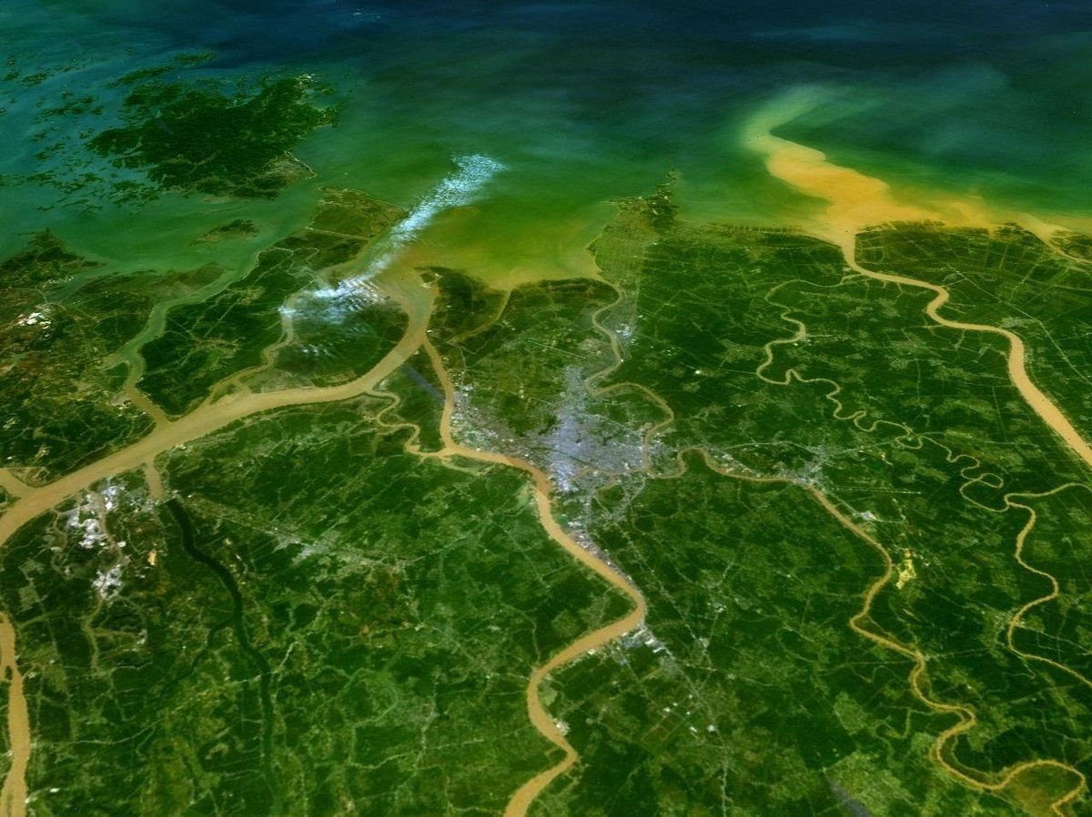
We obtained WorldView-2 imagery from the University of Minnesota in collaboration with the US Forest Service to assess the distribution, area change, and quality of mangrove forests in seven coastal provinces of the Mekong Delta, including Tien Giang, Ben Tre, Tra Vinh, Soc Trang, Bac Lieu, Ca Mau, and Kien Giang.
PV: In your opinion, what results have these studies revealed?
Dr. Pham Hong Tinh: This study has assessed the distribution and change in the area of mangrove forests in 7 coastal provinces of the Mekong Delta in the period of 2015 - 2020. In addition, we also assessed the change in the quality of mangrove forests through the analysis of vegetation indices. These research results are all evaluated in detail for each commune.
Thanks to the application of remote sensing technology and the use of WorldView-2 image data, for the first time the research team was able to accurately determine the location of lost or degraded mangrove forests, and at the same time calculate the area and rate of deforestation and forest degradation for coastal communes with mangrove forests in the Mekong Delta.
From the results of this study, another research group of ours conducted an investigation and assessment of natural and socio-economic conditions in areas with high loss and degradation of mangroves to determine the causes and propose appropriate solutions to ensure sustainable socio-economic development, in parallel with protection and restoration of mangroves.
Our research results are also a good reference source, supporting managers in making decisions related to the conservation, restoration and development of mangroves. Part of the research results were reported at the GIS-IDEAS 2023 International Scientific Conference at the Hanoi University of Natural Resources and Environment and were assessed by delegates as having many prospects for application in the management and monitoring of mangroves.
PV: So what are your recommendations for protecting and minimizing current RNM degradation?
Dr. Pham Hong Tinh: If we look at the general picture, the area of mangrove forests in the country in general and the Mekong Delta in particular has increased in recent years, but when assessing in detail, mangrove degradation still occurs locally and on a small scale in many areas due to the combined impact of many different causes, including socio-economic development activities and the impact of nature, climate change, etc.
From the research results in the Mekong Delta, in order to protect and have solutions to minimize RNM degradation, first of all, it is necessary to conduct research to assess and accurately determine the location, scope and level of RNM degradation, propose solutions to protect and develop RNM suitable for each region, and integrate those results into the socio-economic development strategies of the central and local coastal areas; the planning and socio-economic development of each province and district with RNM.
For socio-economic development activities in areas with mangrove forests such as the construction of infrastructure for power lines, transportation, ports, urban areas, industry or residential areas, it is necessary to fully assess the risk of impact and have solutions to minimize it, as well as strengthen monitoring to promptly prevent negative impacts, loss or deterioration of mangrove quality. For households raising and fishing aquatic products under the forest canopy, it is necessary to continue to propagate to raise awareness, provide technical support to improve productivity and output of aquatic products, and at the same time protect and develop mangrove forests...
PV: Thank you very much!
Source


![[Photo] National Assembly Chairman Tran Thanh Man visits Vietnamese Heroic Mother Ta Thi Tran](https://vphoto.vietnam.vn/thumb/1200x675/vietnam/resource/IMAGE/2025/7/20/765c0bd057dd44ad83ab89fe0255b783)


Comment (0)