
Forecast weather nationwide in the next 10 days
According to the National Center for Hydro-Meteorological Forecasting, from August 18 to the night of August 19, the Northeast and Thanh Hoa will have moderate rain, heavy rain and thunderstorms, with common rainfall of 50-130mm, and in some places very heavy rain over 250mm.
On the day and night of August 18, Nghe An had moderate rain, heavy rain and thunderstorms, rainfall of 30-60mm, in some places very heavy rain over 120mm.
On August 18, Ha Tinh and Quang Tri had moderate rain, heavy rain and thunderstorms, rainfall ranging from 20-50mm, in some places very heavy rain over 80mm.
In addition, on the day and night of August 18, the Northwest, from Hue to Lam Dong and the South, will have scattered showers and thunderstorms, locally heavy to very heavy rain, rainfall of 15-30mm, in some places over 80mm, rain concentrated in the afternoon and night.
Risk of heavy rain with rainfall of 100mm in just 3 hours, potential risk of flash floods and landslides.

Continuous rains, soil moisture models show that some areas in Thanh Hoa, Nghe An, Ha Tinh, Quang Tri provinces are nearly saturated (over 85%) or have reached saturation. In the coming hours, there is a risk of flash floods on small rivers and streams, landslides on slopes in many communes/wards in these provinces.
Thanh Hoa: Dong Luong, Linh Son, Minh Son, Nhu Thanh, Nhu Xuan, Thanh Ky, Xuan Binh, Yen Tho, Cam Thach, Cam Tu, Cong Chinh, Giao An, Hien Kiet, Hoa Quy, Hop Tien, Luong Son, Mau Lam, Muong Lat, Muong Ly, Muong Min, Na Meo, Ngoc Lac, Ngoc Lien, Quan Son, Son Dien, Son Thuy, Tam Lu, Tan Thanh, Thang Loc, Thanh Phong, Thanh Quan, Thien Phu, Thuong Xuan, Trung Ly, Trung Son, Truong Lam, Van Nho, Van Xuan, Xuan Chinh, Xuan Du, Xuan Thai, Xuan Tin, Yen Nhan.
Nghe An: Bich Hao, Hanh Lam, Kim Bang, Tam Dong, Van An, Xuan Lam, Anh Son, Anh Son Dong, Cat Ngan, Con Cuong, Dai Dong, Dong Hieu, Giai Xuan, Hoa Quan, Mau Thach, Minh Hop, Mon Son, Muong Chong, Nghia Hung, Tay Hieu ward, Quy Hop, Son Lam, Tam Hop, Tan Ky, Thanh Binh Tho, Thuan Trung, Tien Dong, Vinh Tuong, Yen Xuan, Bac Ly, Binh Chuan, Cam Phuc, Chau Binh, Chau Hong, Chau Khe, Chau Loc, Chau Tien, Hung Chan, Huu Khuong, Keng Du, Muong Ham, Muong Long, Muong Quang, My Ly, Na Loi, Nga My, Nghia Dan, Nghia Dong, Nghia Hanh, Nghia Khanh, Nhan Hoa, Nhon Mai, Thai Hoa ward, Que Phong, Quy Chau, Tam Quang, Tam Thai, Tan An, Tan Phu, Thong Thu, Tien Phong, Tri Le, Yen Hoa, Yen Na.
Ha Tinh: Co Dam, Ky Xuan, Son Hong, Son Tien, Cam Hung, Cam Lac, Cam Trung, Can Loc, Duc Minh, Duc Quang, Ha Linh, Hong Loc, Huong Pho, Huong Son, Kim Hoa, Ky Anh, Ky Hoa, Ky Khang, Ky Lac, Ky Van, Mai Hoa, Mai Phu, Nghi Xuan, Bac Hong Linh ward, Hai Ninh ward, Hoanh Son ward, Nam Hong Linh ward, Song Tri ward, Vung Ang ward, Son Giang, Son Kim 1, Son Kim 2, Son Tay, Thach Khe, Thuong Duc, Tu My, Tung Loc, Vu Quang, Cam Due, Cam Xuyen, Duc Dong, Duc Tho, Huong Binh, Huong Do, Huong Khe, Huong Xuan, Ky Thuong, Phuc Trach, Thach Xuan, Truong Luu.
Quang Tri: Bac Trach, Phu Trach, Tuyen Binh, Ben Quan, Dan Hoa, Dong Le, Hoa Trach, Huong Phung, Khe Sanh, Kim Dien, Kim Phu, Lao Bao, Minh Hoa, Nam Ba Don, Nam Gianh, Phong Nha, Quang Trach, Tan Gianh, Tan Lap, Tan Thanh, Trung Thuan, Tuyen Hoa, Tuyen Lam, Tuyen Phu, Tuyen Son.
According to the weather forecast from the night of August 19 to August 27, the meteorological agency said that the weather in the North and Thanh Hoa will generally have scattered showers and thunderstorms, with some heavy rain. In particular, on the morning of August 20, this area will experience moderate rain, heavy rain and thunderstorms, some very heavy rain, with common rainfall of 20-40mm, with some places over 100mm; from the night of August 20 to 23, there is a possibility of rain, moderate rain and thunderstorms, with some heavy to very heavy rain.
In the Central region, from August 23 to 27, there will be scattered showers and thunderstorms, with heavy rain in some places.
Central Highlands and Southern region have scattered showers and thunderstorms, locally heavy rain, rain concentrated in the afternoon and evening.
During thunderstorms, beware of extreme weather events such as tornadoes, lightning, hail and strong winds.
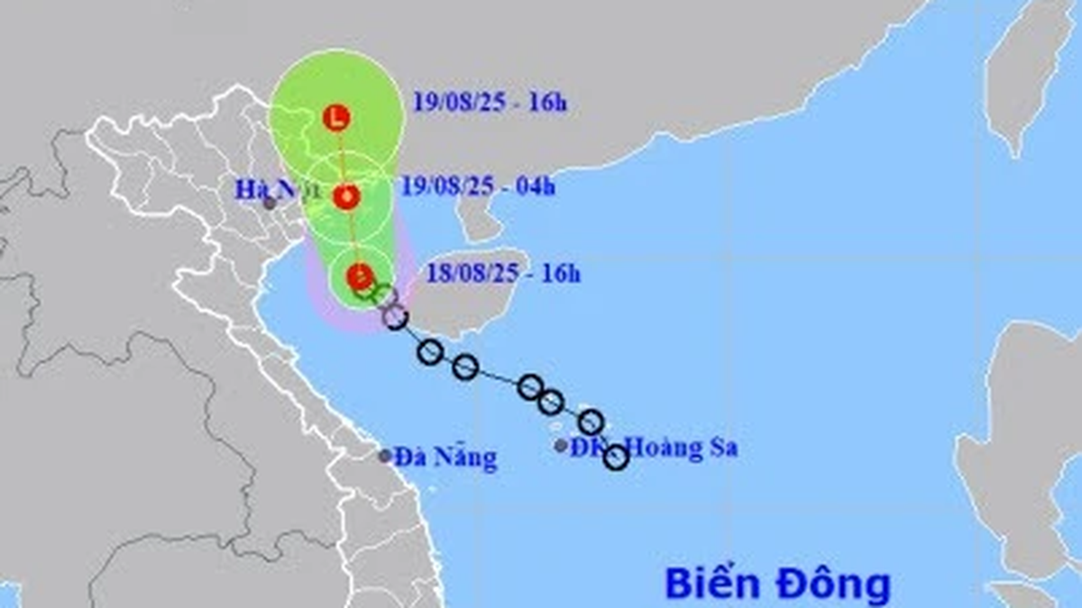
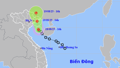
Information about tropical depression In the East Sea, the meteorological agency said that at 1:00 a.m. on August 18, the center of the tropical depression was located in the sea south of Hainan Island (China). The strongest wind near the center of the tropical depression was level 6 (39-49 km/h), gusting to level 8, moving northwest at a speed of about 15 km/h.
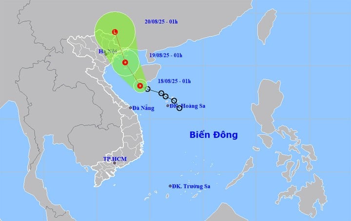
Forecast in the next 24 hours, the tropical depression in the Northern Gulf of Tonkin, moving northwest, speed about 15km/h. The strongest wind near the center of the depression is level 6, gusting to level 8.
At around 1:00 a.m. on August 20, a tropical depression in the southern part of Guangxi province (China) changed direction to the North-Northwest, moving 15-20km per hour and gradually weakened into a low pressure area.
Impact of tropical depression, the sea area east of the southern region of Quang Tri to Hue, the Gulf of Tonkin area (including Bach Long Vi and Co To special zones) has thunderstorms and strong winds of level 6, gusts of level 8, waves 2-3m high, rough seas.
Weather forecast for regions across the country during the day and night of August 18, 2025
Hanoi City Moderate rain, heavy rain and thunderstorms. Northeast to north wind level 2-3. In thunderstorms, there is a possibility of tornadoes, lightning and strong gusts of wind. Lowest temperature 24-26°C. Highest temperature 28-30°C.
Northwest scattered showers and thunderstorms, locally heavy rain, rain concentrated in the afternoon and night. Light wind. During thunderstorms, tornadoes, lightning, hail and strong gusts of wind may occur. Lowest temperature 22-25°C, some places below 21°C. Highest temperature 29-32°C, some places above 32°C.
Northeast Moderate rain, heavy rain and thunderstorms, locally very heavy rain. Northeast to north wind level 2-3. During thunderstorms, there is a risk of tornadoes, lightning, hail and strong gusts of wind. Lowest temperature 23-26°C, in mountainous areas below 22°C. Highest temperature 28-31°C, in some places above 31°C.
Thanh Hoa to Hue Moderate rain, heavy rain and thunderstorms, locally very heavy rain. In Hue, scattered showers and thunderstorms, some places have heavy to very heavy rain. North to northwest wind level 2-3. During thunderstorms, beware of tornadoes, lightning, hail and strong gusts of wind. Lowest temperature 23-26°C. Highest temperature in the North 27-29°C, in the South 29-31°C.
South Central Coast Showers and thunderstorms in some places, scattered showers and thunderstorms in the afternoon and at night, locally heavy to very heavy rain. West to southwest wind level 2-3. During thunderstorms, tornadoes, lightning, hail and strong gusts of wind are forecast. Lowest temperature 24-27°C. Highest temperature 31-34°C, some places above 34°C.
Central Highlands Showers and thunderstorms in some places, scattered showers and thunderstorms in the afternoon and at night, locally heavy to very heavy rain. Southwest wind level 2-3. During thunderstorms, warning of tornadoes, lightning, hail and strong gusts of wind. Lowest temperature 20-23°C. Highest temperature 26-29°C.
Southern Vietnam Showers and thunderstorms in some places, scattered showers and thunderstorms in the afternoon and at night, some places have heavy to very heavy rain. Southwest wind level 2-3. During thunderstorms, there is a possibility of tornadoes, lightning, hail and strong gusts of wind. Lowest temperature 23-26°C. Highest temperature 31-34°C.
HCMC Showers and thunderstorms in some places, scattered showers and thunderstorms in the afternoon and at night, locally heavy to very heavy rain. Southwest wind level 2-3. During thunderstorms, tornadoes, lightning, hail and strong gusts of wind may occur. Lowest temperature 24-26°C. Highest temperature 31-34°C.
Source: https://baolangson.vn/canh-bao-lu-quet-sat-lo-o-4-tinh-mien-trung-va-du-bao-thoi-tiet-ca-nuoc-10-ngay-5056310.html


![[Photo] Prime Minister Pham Minh Chinh attends the opening ceremony of the National Data Center](https://vphoto.vietnam.vn/thumb/1200x675/vietnam/resource/IMAGE/2025/8/18/b5724a9c982b429790fdbd2438a0db44)


Comment (0)