It was at this moment that the "vague" road, appearing and disappearing intermittently since the 1860s, suddenly emerged, becoming clearer and clearer, becoming the main road from the area near the Father Ca Mausoleum, diagonally down to the area near the old Hue Bridge, crossing the Nhieu Loc canal, "taking over" the small extension (of the current Dang Van Ngu road) to the other side of the Nhieu Loc canal to Thien Ly road (then named Thuan Kieu road, then Verdun road, now Cach Mang Thang Tam road).

At the end of Dang Van Ngu street, overlooking the old Nhieu Loc canal, there used to be a bridge, that was Lao Hue bridge.
Photo: CMC
That road (now Bui Thi Xuan Street) must have had a bridge to connect it at that time. And maps from the early 1910s onwards already showed this bridge, though it wasn't named. The new bridge was only about 50-60 meters from the old one.
As mentioned in previous installments, along the Nhieu Loc - Thi Nghe canal, before and after the French colonial period, there were four main bridges recorded. According to the author of the research book "Saigon - Cho Lon City before 1945," only the Diem/Cho Moi/Kieu bridge remained in its original location, while the Thi Nghe and Bong bridges had shifted positions.
Specifically, the Thi Nghe Bridge changed locations twice. The current bridge is more than 360 meters away from the original bridge (in the area of Nguyen Ngoc Phuong apartment complex, at the end of Huynh Man Dat Street, Ward 19, Binh Thanh District today); the current Cao Mien/Bong Bridge was originally located at the site of the Iron Bridge, which is the current Bui Huu Nghia Bridge (next to this bridge, the Cau Bong canal still exists), 170 meters away (Saigon - Cholon Urban Area before 1945, pages 235-240).
Despite the relocation, these two bridges retain their old names. Compared to the distances moved by the Thi Nghe Bridge and the Bong Bridge (360 m and 170 m respectively), the "new Lao Hue Bridge" was moved much less. However, whether it is still called Lao Hue is, frankly, unknown to me, as neither maps nor locals refer to it by that name anymore. Perhaps because it's in a remote, "primitive" area, only of local significance, people have simply forgotten about it.
And one direct reason that determined the unfortunate fate of the Sạn Bridge (to the point that even now, though it has completely disappeared for more than 20 years, no one has yet been able to find a photograph of it): Highway 16 (from the mid-1960s to Thoại Ngọc Hầu Street, now Phạm Văn Hai Street) was wider and paved. Locals grew vegetables in the vegetable gardens of Vườn Rau hamlet along both sides of the unnamed dirt road, later named Trương Minh Ký (now Lê Văn Sỹ) , from Lăng Cha Cả, past the current railway gate number 6 for about 250 meters - towards District 3.
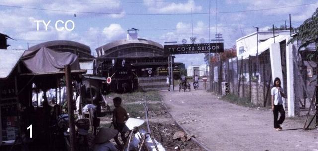
Before 1975, the Railway Company (Hoa Hung Locomotive Repair Workshop and Warehouse, now Saigon Railway Station) crossed the road connecting Bui Thi Xuan Street to the present-day Cach Mang Thang Tam Street.
Photo: Archival material
After 1954, if people in the vegetable-growing areas wanted to transport their vegetables by horse-drawn cart or motorized tricycle, they were forced to take Thoai Ngoc Hau Street (now Pham Van Hai Street), passing through the old, bustling Ong Ta market to reach the Ong Ta intersection, then onto Le Van Duyet - Pham Hong Thai Street to go to Hoa Hung, Saigon, or down to Ba Queo, Hoc Mon.
The width of the Sạn Bridge had shrunk drastically, to just a few meters, nearly half the width of the Ông Tạ Bridge . The bridge was also low. In the late 1960s, whenever there was heavy rain, the water would only reach the Ông Tạ Bridge, but the Sạn Bridge would be completely submerged. My childhood memories from the late 1960s with my friends in the neighborhood are of the flooding; we would cling to the iron railings on either side of the Sạn Bridge to splash water on it while playing games.
And one important reason: after about two decades, in the early 1930s, a locomotive maintenance and repair workshop and goods storage facility (before 1975, the Saigon Railway Department, now the Saigon Locomotive Enterprise) was built, blocking the road connecting this bridge to Verdun Street (renamed Thuan Kieu Street, after 1954 Le Van Duyet Street, now Cach Mang Thang Tam Street).
It can be said that from this point on, the "new Lao Hue bridge" no longer served as a "straight line" from Lang Cha Ca to the old Thien Ly/Thuan Kieu/Verdun road. The remaining road on both sides of this factory has increasingly narrowed, now just a small, slightly winding alley, one or two meters wide.
It should be added that if the old Lao Hue bridge still existed today, it would have suffered the same fate, as the Hoa Hung locomotive repair factory and warehouse – now Saigon Railway Station – also cut across it in the 1930s. (to be continued)
Source: https://thanhnien.vn/cau-lao-hue-bien-mat-hay-van-con-185250223213917263.htm


![[Video] Sunset at Lap An Lagoon – Where the sun sets over the fishing nets](https://vphoto.vietnam.vn/thumb/340x192/vietnam/resource/IMAGE/2026/05/31/1780192137701_beach-landscape-sea-water-nature-grass-745871-pxhere-com.jpeg)


Comment (0)