
It is not impossible that there will be some areas where there will be heavy rain.
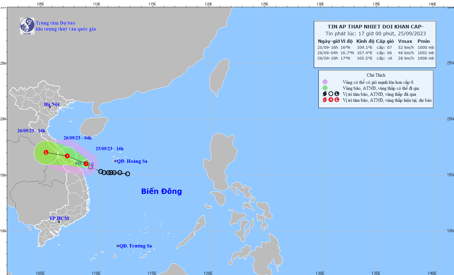
According to Mr. Vu Anh Tuan, Deputy Head of Weather Forecast Department, National Center for Hydro-Meteorological Forecasting, at 4:00 p.m. on September 25, the center of the tropical depression was at about 16.0 degrees North latitude; 109.1 degrees East longitude in the sea area of Thua Thien Hue - Quang Nam. The strongest wind near the center of the tropical depression is level 6-7 (39-61 km/h), gusting to level 8-9. Moving in the West Northwest direction at a speed of 15 km/h. At midnight to morning, the tropical depression moved inland from Quang Binh to Thua Thien Hue, then moved to Southern Laos to form a low pressure area.
Due to the influence of the tropical depression, there has been moderate rain, heavy rain, and very heavy rain in some places in the North and Central Central regions. The rainfall from 00:00 on September 25 to 16:00 on September 25 was generally 50-100mm, locally over 150mm in some places such as: Hoi An (Quang Nam) 205.8mm, Da Nang 215mm, Huong Phu (Thua Thien Hue) 299mm, Trieu Ai (Quang Tri) 205mm, Huong Thuy (Ha Tinh) 206mm...

Mr. Vu Anh Tuan warned that due to the influence of the tropical low pressure circulation, the sea area from Quang Tri to Quang Nam (including Con Co and Cu Lao Cham island districts) will have strong winds of level 6-7, gusts of level 8-9, and rough seas. The Gulf of Tonkin will have strong winds of level 6, gusts of level 7-8, and rough seas.
The South China Sea area (including the Truong Sa archipelago), the sea area from Binh Thuan to Ca Mau has strong southwest winds at level 6, gusting at level 7-8, rough seas.
From the night of September 25 to the morning of September 26, coastal areas from Quang Binh to Quang Nam will have strong winds of level 6, gusting to level 8; deep inland, winds of level 6-7 will be experienced. Sea areas from Quang Tri to Quang Nam (including Con Co and Cu Lao Cham island districts) will have waves 2.0-3.0m high. In the Gulf of Tonkin, waves will gradually rise to 2-3m.
Regarding rain warnings, hydrometeorological experts said that from now until September 27, in the Central Central region, there will be heavy to very heavy rain with common rainfall from 100-200mm, in some places in Quang Tri-Thua Thien Hue over 200mm; in the South Central, Central Highlands and Southern regions, there will be moderate rain, heavy rain and thunderstorms, locally very heavy rain with common rainfall from 100-150mm, in some places over 200mm. From now until September 28, in the area from Thanh Hoa to Quang Binh, there will be heavy to very heavy rain with common rainfall from 200-400mm, in some places over 450mm.
Experts note: "Due to the activity of the tropical depression combined with the circulation of the tropical depression, it is possible that there will be areas where heavy rain will occur, with high intensity rain in a short period of time causing flash floods and landslides. Localities need to closely monitor the development of the tropical depression."
Flash flood warning system warns of high risk in many areas
Further warning about the above types of natural disasters, Mr. Hoang Van Dai, Deputy Director of the National Center for Hydro-Meteorological Forecasting, said that by the afternoon of September 25, heavy rains were concentrated in the area from Ha Tinh to Binh Dinh and the Northern Central Highlands. The flash flood warning system is warning of high risks in the above areas. Meanwhile, this is an area with many ravines as well as midlands and mountainous areas, so there is a very high risk of flash floods and landslides.
According to this expert, on September 25-27, there is a possibility of a flood on rivers from Nghe An to Thua Thien Hue. The flood amplitude in the upstream of the rivers will be 3-8m, in the downstream 1.5-3m. Also during this time, the peak flood level in the upstream of Ca River (Nghe An), La River (Ha Tinh), rivers in Quang Tri, Thua Thien Hue will be at alert level 1 and above alert level 1; the downstream of Ca River, La River will be below alert level 1; rivers in Quang Binh will be at alert level 1 and 2.
Mr. Hoang Van Dai, Deputy Director of the National Center for Hydro-Meteorological Forecasting, warned of a high risk of flash floods and landslides in mountainous areas, localized flooding in low-lying areas along rivers and urban areas from Nghe An to Thua Thien Hue.
Source


Comment (0)