
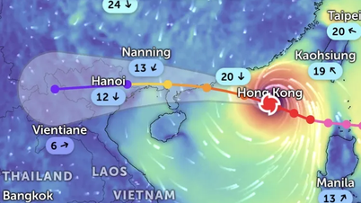
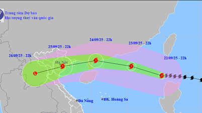
The latest forecast from the National Center for Hydro-Meteorological Forecasting shows that there is a possibility of a tropical cyclone appearing in the East Sea in the middle of the week, while localized heavy rain, heat waves and minor floods continue to occur in many areas.
International meteorological models such as GFS (USA) and ECMWF (Europe) agree on the possibility of a cyclone forming in the northeastern waters of the East Sea between June 11 and 13.

On land, the National Center for Hydro-Meteorological Forecasting said that in the Northern region, the weather in the first two days of the week (June 8 and 9) will remain sunny, with temperatures above 36 degrees Celsius in the plains and midlands. From the night of June 8 to the morning of June 10, showers and thunderstorms will increase, with heavy rain in mountainous areas, with the potential risk of tornadoes, lightning and hail. From the afternoon of June 10, the rain will decrease in the North, and the weather will be sunny again in the afternoon.
In the Central region, the heat wave continues from Nghe An to Phu Yen in the first 3 days of the week, with temperatures above 37 degrees Celsius in some places. After June 10, the intensity of the sun will decrease slightly, with scattered showers and thunderstorms in the evening. Meanwhile, the South Central region is more stable with sunny days and scattered rain in the afternoon and evening. Coastal provinces from Quang Tri to Khanh Hoa need to pay special attention to the possibility of indirect impacts if the tropical cyclone in the East Sea makes landfall.
The Central Highlands and the South are entering the peak of the rainy season. From June 7 to 11, most localities will experience moderate rain, with some places experiencing heavy to very heavy rain in the afternoon and evening, then transition to a state of less rain but still scattered thunderstorms. The risk of flash floods and localized flooding in low-lying urban areas, especially Ho Chi Minh City and the Central Highlands, needs to be closely monitored.
It is forecasted that a low pressure area will likely strengthen into a tropical cyclone (low pressure or tropical depression) in the East Sea from June 11 to 13, with a probability of formation of 50-60%. Although it is still early to determine the path and intensity, experts warn that this could be the first cyclone to affect our country in this year's rainy and stormy season.
Source: https://www.sggp.org.vn/co-the-xuat-hien-mot-xoay-thuan-tren-bien-dong-post798508.html
![[Photo] General Secretary To Lam meets voters in Hanoi city](https://vphoto.vietnam.vn/thumb/1200x675/vietnam/resource/IMAGE/2025/9/23/d3d496df306d42528b1efa01c19b9c1f)

![[Photo] The 1st Congress of Party Delegates of Central Party Agencies, term 2025-2030, held a preparatory session.](https://vphoto.vietnam.vn/thumb/1200x675/vietnam/resource/IMAGE/2025/9/23/e3a8d2fea79943178d836016d81b4981)

![[Photo] Prime Minister Pham Minh Chinh chairs the 14th meeting of the Steering Committee on IUU](https://vphoto.vietnam.vn/thumb/1200x675/vietnam/resource/IMAGE/2025/9/23/a5244e94b6dd49b3b52bbb92201c6986)


Comment (0)