
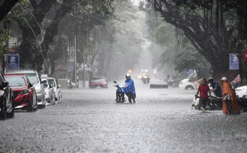
Specifically, from the night of June 28th to July 2nd, the northern region is likely to experience a widespread thunderstorm, with moderate to heavy rain in the midland and mountainous areas, and very heavy rain in some places. The predicted rainfall could reach 150-300mm/period, and over 500mm in some areas.
This is accompanied by a high risk of extreme weather events such as tornadoes, lightning, flash floods, landslides, and flooding in low-lying areas.
Meanwhile, the Central region will generally experience sunny weather from now until June 28th. From June 29th to July 2nd, the weather will be mostly dry with sunshine, and some areas will experience hot weather. The Central Highlands and Southern regions: Today, June 27th, there will be rain, moderate rain, and locally heavy rain in some areas, with rainfall ranging from 20-40mm/24h, and in some places exceeding 70mm/24h.
From June 28th to 30th: Sunny days, scattered showers and thunderstorms in the evening, no signs of widespread heavy rain. From July 1st to 2nd: Rain, moderate rain, with localized heavy rain in some areas, rainfall from 20-40mm/24h, localized areas exceeding 70mm/24h.
Notably, the National Center for Meteorological and Hydrological Forecasting predicts that the period from June 21st to July 20th will be a time of significant weather fluctuations. In June, the country witnessed several extreme weather events, most notably Typhoon WUTIP (Typhoon No. 1), which formed in the East Sea on June 10th. Although it did not directly make landfall in Vietnam, the typhoon's circulation still caused widespread heavy rainfall, affecting many areas.
In Central Vietnam, heavy rain occurred from the night of June 10th to 13th, mainly due to the influence of the storm's circulation. Localities from Ha Tinh to Quang Nam recorded rainfall amounts ranging from 250 to 550 mm, with some areas exceeding 600 mm. Several meteorological stations, such as Dong Ha (Quang Tri), Da Nang , A Luoi, and Nam Dong (Thua Thien Hue), recorded rainfall levels exceeding historical records.
The Central Highlands and Southern Vietnam are also not immune to the unusual weather trends. Northern Central Highlands experienced heavy rainfall during the same period, with precipitation ranging from 100–200 mm, and exceeding 250 mm in some areas. Simultaneously, the heatwave continues in Northern and Central Vietnam. Hanoi experienced three heatwaves in June, with temperatures reaching 40.6°C at one point. Along the coast from Quang Binh to Hue, the heatwave persisted continuously from mid-May to mid-June.
As July approaches – the peak of the rainy and stormy season – weather in many regions across the country is forecast to remain erratic. Northern and North Central Vietnam are expected to experience rainfall 15-30% higher than the multi-year average, meaning an increased risk of flooding, flash floods, and landslides. Meanwhile, Central and South Central Vietnam face 10-20% less rainfall than average, increasing the risk of drought and forest fires.
Average temperatures in Northern and North Central Vietnam in July are similar to previous years, while other areas are forecast to be 0.5–1°C warmer. During this time, the East Sea is likely to experience one to two typhoons or tropical depressions – a number comparable to the average for the same period.
The National Center for Meteorological and Hydrological Forecasting also warned that localized heavy rainfall in the northern and north-central provinces could occur unexpectedly, posing a risk of flash floods and landslides, especially in mountainous and low-lying areas. Thunderstorms, lightning, and hail remain a potential risk during transitional weather periods.
Source: https://cand.com.vn/Xa-hoi/cuoi-thang-6-sang-thang-7-thoi-tiet-co-nhieu-bien-dong-manh--i772993/


![[Photo] General Secretary and President To Lam presides over a meeting on preparations for the review of one year of operation of the three-tiered government system.](https://vphoto.vietnam.vn/thumb/1200x675/vietnam/resource/IMAGE/2026/06/02/1780391821195_a1-bnd-4595-9717-jpg.webp)


Comment (0)