
TPO - Satellite images show an unusual cloud "vortex" lurking off the coast of Spain and Portugal. Researchers are not sure what causes the rotation of this strange structure, but ocean currents and extreme heat waves may play a role.
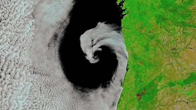 |
A large spiral cloud has been spotted nestled perfectly along the west coast of the Iberian Peninsula. Researchers aren't exactly sure what created this unusually perfect shape. (Image: NASA Earth Observatory/MODIS/) |
This striking image shows an unusual spiral cloud nestled perfectly along the west coast of the Iberian Peninsula.
The spiral consists of moist, cloudy air from the ocean swirling together with dry, inland air by a phenomenon called cyclones — the same mechanism responsible for creating tropical storms like hurricanes, typhoons and tornadoes, according to NASA's Earth Observatory.
However, in this case, the rotation is much slower and weaker than that in tropical cyclones, so the dry air and clouds do not mix properly, preventing a proper vortex from forming. This also prevents any clouds from passing over land.
“The exact cause of this [unusual] mid-latitude rotation remains a mystery,” said Stephen Jospeh Munchak, a meteorologist at NASA’s Mesoscale Atmospheric Processes Laboratory. “However, it may be caused by a vortex — a temporary swirl of water that extends deep below the ocean’s surface.”
An extreme heatwave that swept across southern Europe also created a typically large temperature difference between cloudy air over the sea and dry air over land. This may have prevented the two fronts from mixing, helping to create the beautiful spiral shape. According to NASA’s Earth Observatory, temperatures in Spain and Portugal were in the high 40s when this image was taken.
Interestingly, marine stratocumulus clouds are typically only found along the western coasts of Earth’s landmasses. This is because they form when cold water from the deep ocean is brought to the surface by the Earth’s rotation – a phenomenon known as the Coriolis effect – which cools the air above and causes water vapor to condense into clouds.
The rotating clouds in the image stretch hundreds of miles and can last for several days, but they are unlikely to release any precipitation, according to NASA's Earth Observatory.
According to Live Science
Source: https://tienphong.vn/trai-dat-nhin-tu-vu-tru-dam-may-hinh-xoan-oc-quay-cham-bi-an-om-bo-bien-iberia-post1645159.tpo


Comment (0)