

According to the National Center for Hydro-Meteorological Forecasting, at 1:00 a.m. this morning, August 23, the center of the tropical depression was about 730 km east of Hoang Sa special zone. The strongest wind near the center of the tropical depression was level 7, that is, from 50 - 61 km/h, gusting to level 9.
The tropical depression is moving west-northwest at a speed of about 25 km/h. It is forecasted that today, the tropical depression will strengthen into a storm - storm number 5.

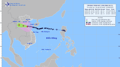
Storm No. 5 is forecast to cause heavy rain from August 24 to 27 in the provinces from Thanh Hoa to Hue City. PHOTO: National Center for Hydro-Meteorological Forecasting
Forecast at 1:00 a.m. tomorrow, August 24, the center of storm No. 5 is located at about 17.6 degrees north latitude and 113.0 degrees east longitude, in the sea northeast of Hoang Sa special zone.
Due to the influence of the tropical depression that will strengthen into storm No. 5, the sea area in the northern East Sea (including Hoang Sa special zone) today will have strong winds of level 6 - 7, then increase to level 8. The area near the storm center will have winds of level 9 - 10, gusting to level 12. Waves are 3 - 5 m high, near the storm center waves are 4 - 6 m high, very rough seas.
It is forecasted that from August 24, the northern East Sea (including Hoang Sa special zone) will have strong winds increasing to level 10 - 11, gusting to level 13. Waves will be 4 - 7 m high, very rough seas with thunderstorms and heavy rain. Accordingly, ships operating in the above-mentioned dangerous areas are likely to be affected by thunderstorms, strong winds and big waves.
According to the National Center for Hydro-Meteorological Forecasting, it is forecasted that by August 25, storm No. 5 will move inland to our country. With the current impact scenario, storm No. 5 has a very wide circulation, affecting the northern and north central coasts.
Accordingly, the coastal area from Nghe An - Quang Tri will be the main area affected by storm No. 5, with strong winds of level 10 - 11, gusts of level 13 - 14. Storm No. 5 will cause heavy rain from tomorrow, August 24 to August 27 in the provinces from Thanh Hoa - Hue City, with rainfall ranging from 150 - 300 mm, in some places over 600 mm./.
According to Thanh Nien Newspaper
Source: https://thanhnien.vn/du-bao-hom-nay-bien-dong-co-bao-so-5-song-cao-6-m-185250823075733191.htm
Source: https://baolongan.vn/du-bao-hom-nay-bien-dong-co-bao-so-5-song-cao-6-m-a201214.html

![[Photo] General Secretary To Lam attends the 80th anniversary of Vietnam's diplomacy](https://vphoto.vietnam.vn/thumb/1200x675/vietnam/resource/IMAGE/2025/8/25/3dc715efdbf74937b6fe8072bac5cb30)


Comment (0)