

Peaceful and familiar—that was our first feeling as the first wheels rolled across the soil of Laos, the Land of a Million Elephants, at the beginning of the 2024 rainy season. The people, the rice paddies, the scenery… all evoked that feeling.
Artist Do Duc marveled at the undulating curves of the mountain ranges against the sky. The Lao couple selling hot corn to director Pham Loc had very kind faces. If there were no language barrier, it would feel as if one were in some familiar countryside in Vietnam…
1. The roads aren't great, but they're much better than before. With vast land, sparse population, and limited economic resources, it's not easy to invest in infrastructure in every area at once. Fortunately, the first rains of the season only caused us trouble in one section due to landslides, mud, and slippery conditions. Everything eventually worked out.
We passed through the Cau Treo border gate located on top of the Keo Nua pass, the end point of National Highway 8 in Huong Son district ( Ha Tinh province ), connecting to the Nampgao border gate in Bolikhamxay, a province in Central Laos with a strategic location in the East-West economic corridor, connecting Vietnam and Thailand. Throughout history, this land has experienced many wars with the Siamese.
The road we traveled ran through the Nakai-Nam Theun National Biodiversity Area, Laos' third largest nature reserve. Bolikhamxay has many rivers. The largest is the Nam Kading, meaning "Water Flowing Like a Bell," which flows into the Mekong River. The province's longest mountain ranges are the Phou Louang, running southwest; the Phou Ao range, running southeast; the Thalabat range, running southwest; and the Pa Guang range, running northeast. In Khamkheuth district, there is a karst limestone formation, considered the largest in Southeast Asia. Numerous small peaks form a karst forest.
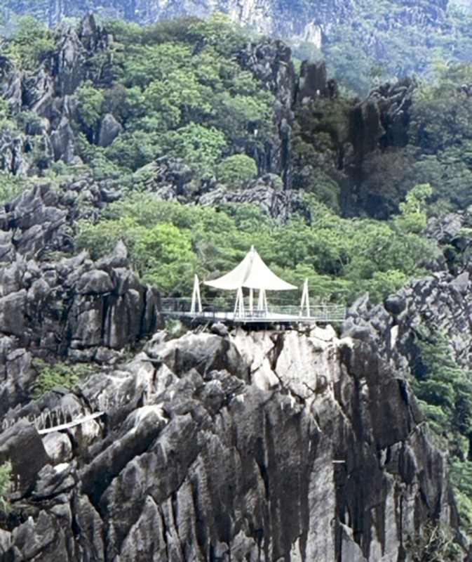
We crossed the Nam Kading River on a beautiful sunny afternoon. Although we didn't hear the sound of "Water flowing like a bell," we were able to admire the peaceful riverside villages, the familiar docks with their boats and people. The Rock Forest is a unique beauty of Bolikhamxay. In the town of Lak Sao, the rocks grow close together, like trees in a forest, jutting out on both sides of the road. We had the opportunity to stop at a resort named after the rocks: Rock View Point, to admire the beautiful scenery. The peaceful green of the forest trees interspersed with the pristine gray rocky mountains creates a captivating natural landscape. Many foreign tourists come here to enjoy this beauty.
Paksan, the provincial capital of Bolikhamxay, is located on National Highway 13, right on the Thai border. It's a quiet city with small riverside streets, ancient temples, and pagodas. Paksan is being developed and built to become a center for commerce, services, and tourism . The large bridge connecting Paksan to Meuang town in Thailand is nearing completion. We spent an afternoon strolling around Paksan, admiring the illuminated streets, and enjoying our first meal in Laos with local dishes. Prices were very reasonable; a delicious meal for four cost just over 300,000 Kip. We stayed at Khem Khong, a small, comfortable, and clean hotel. A single room cost only 200,000 Kip. Mornings in Paksan are very peaceful. The slow pace of life is characteristic of the Laotian people. Most shops and restaurants stay open late.
2. From Paksan, we headed north towards Vientiane to visit Wat Phabath, a temple whose name in Lao means "Footprint of Buddha." The full moon of the first lunar month is a festival held there every year. Within the temple grounds are many large, ancient trees. The statues inside are made of clay, carved from stone, or from precious wood. The road to Vientiane is quite good; it's the main route connecting northern and southern Laos.
Returning to Vientiane after more than 10 years, I can clearly feel the changes in the capital of our neighboring country. The city is larger, the pace of life is more vibrant, and alongside the preserved traditional cultural features, there are new colors.
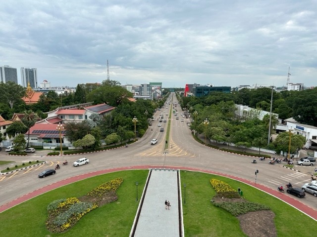
Standing atop Patuxay Arch, I felt this even more strongly. From the top of this famous structure, looking in all four directions, one can take in a Vientiane that is building and developing. Beside That Luang, ancient temples stand high-rise buildings and new neighborhoods stretching along the Mekong River, the gentle Mother River that has for generations been the source of life for this city.
The Patuxay Arch, known as the Arc de Triomphe in Lao, was our first visit to Vientiane. It was a typical day, and we encountered many foreign tourists. Patuxay is 55 meters high, with four sides, each 24 meters wide, and has seven main towers and two smaller levels. The structure is modeled after the Arc de Triomphe in Paris, yet retains distinct features of Lao architecture. The windows along the staircases are designed in the shape of Buddha statues. The seven towers are connected by spiral staircases. Each level features exhibits about Lao culture, the country, and the construction process. The Patuxay Arch was built to honor the soldiers who fought in the Lao people's struggle for independence.
We visited That Luang in the heart of the capital, a national symbol of Laos, associated with the relocation of the capital from Luang Prabang to Vientiane in 1563.
In 1566, That Luang was built on the site of an old temple. That Luang is one of the largest Buddhist stupas in Laos, standing 45 meters tall. Beside the stupa is a temple complex with the famous reclining Buddha statue. The That Luang Festival is held annually in November with solemn ceremonies including bathing the Buddha, offering rice, and praying for blessings.
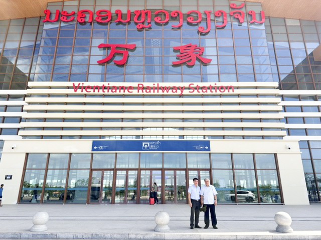
We visited the Vientiane-Kunming railway station, a modern facility that has only recently come into operation. This railway line has significantly contributed to increasing traffic volume, shortening travel time, reducing service costs, and creating a strong transformation in economic activities, trade, import and export, and tourism between the capital Vientiane and other regions of Laos and with provinces of China.
3. We left Vientiane for Luang Prabang via National Highway 13, a route over 230 km long with many difficult sections.
The stretch from Vientiane to Vang Vieng, about 100 km, is quite good thanks to the highway. I remember my first visit to Vang Vieng with colleagues from the Lao News Agency (KPL) more than 10 years ago. It was an eco-tourism area nestled in the mountains and forests. There were many sports and recreational activities reflecting Lao culture. International tourists flocked there. They climbed mountains, swam down the Vang Vieng River, rode the cable car across the stream, or camped in the forest. The Lao people have developed a tourist area that suits the potential of this place. Returning this time, I can sense many changes taking place.
Luang Prabang, the former capital of Laos, possesses a nostalgic beauty. It served as the capital from the 13th to the 16th centuries. Alongside ancient temples showcasing traditional Lao architecture are two-story wooden houses in the French style with front balconies, creating a warm and inviting atmosphere. Time has left its mark on this capital city, through the changes and vicissitudes of history. In 1995, Luang Prabang was designated a UNESCO World Heritage Site for architecture, religion, and culture. Some say Luang Prabang's beauty is a blend of Da Lat and Hoi An.
Luang Prabang is situated on a peninsula between the Mekong and Nam Khan rivers, with a predominantly mountainous terrain, bordering the Vietnamese provinces of Dien Bien and Son La. The city has an international airport and significant potential for economic and tourism development; it serves as an important transit hub connecting to the capital Vientiane, Thailand, China, and the northwestern provinces of Vietnam. Many airlines operate flights to Luang Prabang.
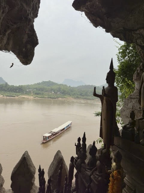
The Pak Ou Caves are a famous historical site in Luang Prabang, home to approximately 4,000 ancient Buddha statues. Legend says that 300 years ago, Laotian people would row boats upstream at night to the caves to hide the Buddha statues when the capital, Luang Prabang, was under foreign invasion. An elderly Laotian man with a simple, genuine smile took us across the Nam Khan River in his motorboat. Thousands of Buddha statues of various sizes and styles adorned the cave walls, creating a solemn and respectful atmosphere. On our way back to Luang Prabang from Pak Ou, we visited the riverside craft villages known for their weaving, rice wine making, and elephant farms – all very attractive tourist destinations.
Phousi Hill is a famous landmark in Luang Prabang. We followed the pilgrims up the 338 steps to the sacred temple located on the hilltop. From here, we could also get a panoramic view of Luang Prabang in all directions, watching the ancient capital as the sun set.
During our time in Luang Prabang, we also had meetings with the Vietnamese community. These included Ms. Kieu Thi Hang Phuc, Consul General, and staff from the Vietnamese Consulate in Luang Prabang; young people from the Dien Bien province's trade representative office; and artist Vu Thanh Hai, a very successful Hanoi resident in Luang Prabang… These meetings helped us better understand the lives of the Vietnamese community and Vietnam-Laos relations in this northeastern region.
4. The journey to Xiengkhuang involved crossing a steep mountain pass. The traffic on this route was quite heavy, with many trucks weighing 30-40 tons. Trucks carrying ore, timber, and agricultural products headed north, while those carrying goods, equipment, and machinery headed south. With such a high volume of traffic, road deterioration was inevitable. Many bends in the road were congested, forcing our vehicle to hug the side of the mountain to yield to the trucks.
We arrived in Phonxavan town, the capital of Xiengkhuang province, in the afternoon and immediately visited the Plain of Jars. The weather was still sunny and beautiful. It was fortunate that we had waited until the next morning, as the mountainous area is often foggy, and the sun wouldn't come until around noon. This is a famous landmark in Xiengkhuang. In the afternoon sun, the ancient jars, carrying mysterious messages from prehistoric times, are scattered across the wide hillsides, amidst green meadows and forests. This tourist attraction is near Phonxavan town. Most tourists visit here.
The Plain of Jars is a vast area containing thousands of stone jars, clustered together along the valleys and plains of the Xiengkhuang Plateau. According to archaeological records, over 90 jar sites have been discovered in this region. The jars vary in height and diameter from 1 to 3 meters, all crafted from stone. They are cylindrical in shape, with the base larger than the mouth. It is believed that the jars originally had lids, although very few remain. Some of the jar lids are carved with images of animals.
From the late 1930s, archaeologist Madeleine Colani (1866-1943), who worked at the French School of Far Eastern Studies and was very famous for her archaeological discoveries in Vietnam, suggested that these jars were related to prehistoric burial practices. Archaeologists later determined that the jars here are 1,500-2,000 years old and considered the Plain of Jars one of the most important prehistoric sites in Southeast Asia. During the war, the Americans repeatedly bombed this area. Even now, some places remain unsafe due to unexploded bombs. That afternoon at the Plain of Jars, I watched and filmed children playing among the ancient jars. Life continues through generations, from ancient times to the present and into the future.
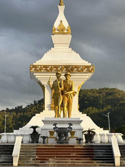
Returning from the Plain of Jars, we visited the Vietnam-Laos fighting alliance memorial. The image depicts two Vietnamese and Laotian soldiers side-by-side, weapons in hand, ready to charge forward. The memorial is located in Xiengkhuang, a land that witnessed many major battles fought by Vietnamese volunteer soldiers and their Laotian comrades, achieving resounding victories in their shared struggle for independence and freedom.
We offered incense at the memorial and spent time visiting Phonsavan, a town with its own unique beauty in this historical land. Phonsavan has Craters Restaurant, owned by a Vietnamese man, decorated with bomb casings and even a collection of weapons and landmines that once destroyed life on this land. Many Western tourists who come to Xiengkhuang seek out Craters Restaurant.
5. The road from Xiengkhuang to Sam Neua improved, though it still had many mountain passes. The scenery was beautiful, with clouds drifting over the hazy green mountain ranges. Villages nestled beside rivers and streams. It was a peaceful and tranquil morning. When we stopped in the town of Namneu along the road, I visited a small house. Two Lao women, with kind and cheerful faces, invited us to sit down and have some water. Although they couldn't speak Vietnamese, they seemed very happy to learn that we were visitors from Vietnam. Meeting them reminded me of the song "The Girl of Sam Neua" by composer Tran Tien. During the war years, these women were probably the same age as the girl in the song. In their memories, they surely still cherish images of the Vietnamese volunteer soldiers in this revolutionary base area.
Sam Neua town is nestled in a small valley. From above, the square, gardens, offices, and houses stretch along the narrow streets. We explored the streets. A monument with a tower-like symbol stands in the main square, where the Hua Phan provincial government headquarters are located. The commercial area is quite bustling. Several new hotels have been built. The central garden features tall stone pillars side by side and beautiful statues. Children are playing in the park, alongside tourists and elderly people strolling leisurely.
From Sam Neua to Viengxay, the capital of the Lao resistance, is only about 30km. Viengxay, meaning "victory" in Lao, was the base of the Lao revolution from 1964 to 1975. Thousands of people lived in interconnected caves deep within the mountains during the war years. This was where the leaders of the Lao People's Revolutionary Party and the Lao Resistance Government, as well as the agencies of their leadership apparatus, lived and worked throughout the war. There were tunnels used for meetings, study, hospitals, schools… all hidden deep within the mountains.
Life in Viengxay today has changed considerably. Many new buildings have sprung up on the former war zone. The most attractive feature here remains the relics of the resistance era. All of them are still preserved in the memories of the local people. We visited the central exhibition hall next to the area where the revolutionary leaders lived; we also visited the mountain cave where General Secretary Kaysone Phomvihane, President Souphanouvong, and many key Lao leaders lived and commanded the resistance. The living, working, and meeting places of the Lao leaders were very simple due to the harsh conditions of war. The meeting room of the Politburo of the Lao People's Revolutionary Party had only a long table and seven chairs; the resting place was also seven very simple individual beds… A plaque affixed to the cliff indicates that all the bunkers here were directly built by Vietnamese engineering troops.
Phu Khe (meaning cinnamon forest), the base of the Lao propaganda and press agencies, was located not far from the leadership headquarters. The Pathet Lao News Agency was also based in Phu Khe. This was where many cadres, reporters, and technicians of the Vietnam News Agency lived and carried out their duties to assist Laos.
In the book "Vietnam News Agency and KPL - Growing Up Through the Years," jointly compiled by the two news agencies, there are many pages of memoirs from Vietnamese and Lao officials and reporters. These memories live on today. Ms. Dao Huong, a successful Vietnamese businesswoman currently residing in Pakse, still recounts how journalist Dang Kien, former Head of the Foreign News Department of the Vietnam News Agency, while residing in Laos, wholeheartedly helped her and other Vietnamese expatriates connect with agencies and localities in Vietnam immediately after 1975. This enabled her to return to her homeland, seek opportunities for cooperation and business, and achieve success to this day. Ms. Dao Huong said that when journalist Dang Kien was still alive, she and a friend visited him in Hanoi to express their gratitude.
In Viengxay, we met with businessman Le Hung, Chairman of the Vietnamese Association in Hua Phan. Originally from Thanh Hoa province, he is a former military officer who invested in construction and services in Hua Phan. Le Hung shared with us the life of the Vietnamese community and the cooperation between Vietnamese businesses and their Lao counterparts. This cooperation, within the framework of the special Vietnam-Laos relationship, has achieved many successes and holds significant potential for the future. We had a cordial meal with Le Hung and his wife in the heart of Viengxay, not far from the historical revolutionary base that made this region famous.
We said goodbye to our friends in Viengxay and returned to Vietnam via the Na Meo border gate (Thanh Hoa province), promising to return one day soon. This marked the end of a trip filled with experiences and unforgettable impressions of the people and our brotherly country of Laos.
Source: https://baolangson.vn/du-ky-xu-trieu-voi-5031963.html


Comment (0)