
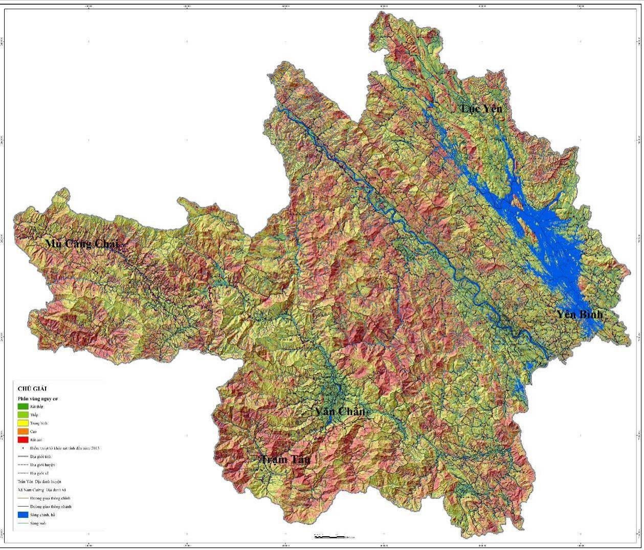
In 2016, after completing the Project "Investigation, assessment and zoning of landslide risk warning in mountainous areas of Vietnam" in Yen Bai province, the Ministry of Natural Resources and Environment transferred and instructed the locality to use this map set.
* Identify 5 levels of landslide risk
According to the Institute of Geological Sciences and Mineral Resources, a landslide risk zoning map at a scale of 1:50,000 for Yen Bai province (including 9 district-level administrative units and 179 commune-level administrative units) was established with 5 risk levels: very high, high, medium, low and very low.
In which, the distribution area of each zoning level accounts for the following proportions: very high landslide risk accounts for ~18% of the natural area of Yen Bai province; high landslide risk ~32%, medium landslide risk ~28%, low landslide risk ~4% and very low landslide risk ~18%. Therefore, Yen Bai province is identified as having a high landslide risk in the mountainous region of Vietnam.
The results of zoning and assessing the risk of landslides for 9 district-level administrative units of Yen Bai province show that 3 districts are identified as having a very high risk of landslides, including Mu Cang Chai, Tram Tau and Van Yen districts; 3 districts are identified as having a high risk of landslides, including Luc Yen, Tran Yen and Van Chan districts; 3 districts are identified as having a medium risk of landslides, including Yen Binh district, Yen Bai city and Nghia Lo town.
Overall assessment in each area by commune-level administrative unit shows that out of 179 communes/wards of Yen Bai province, 53 communes are identified as having a very high risk of landslides, 77 communes are identified as having a high risk of landslides, 42 communes are identified as having a medium risk of landslides, 2 communes are identified as having a low risk of landslides and 5 communes are identified as having a very low risk of landslides.
* 1/4 of Van Yen district is in a very high risk area
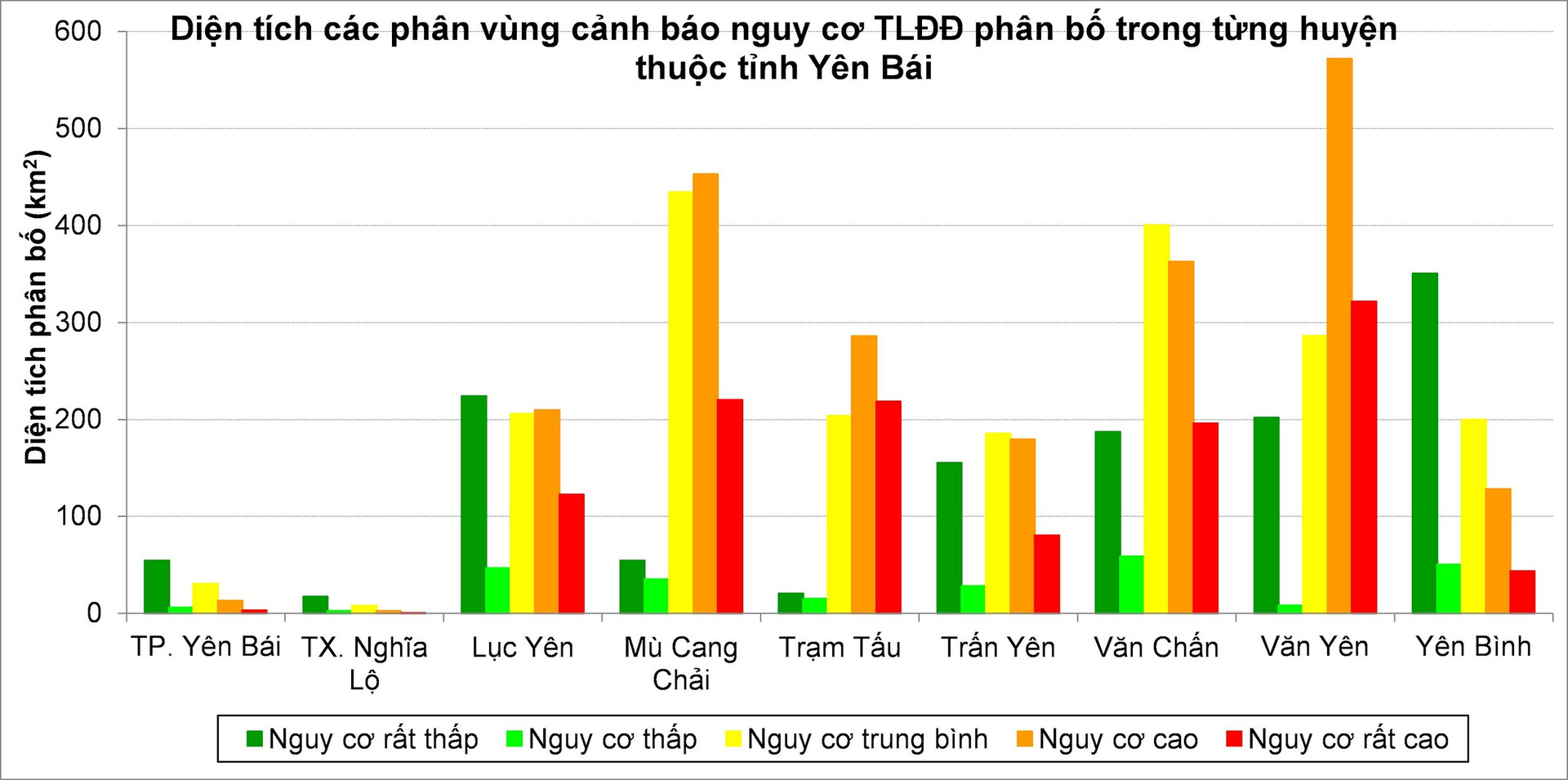
The area with very high risk of landslides is distributed in Yen Bai province with a total area of ~1,200 km2 , accounting for ~18% of the total natural area of the province.
Areas with very high risk of landslides have the largest distribution area in Van Yen district (~322 km 2 ), followed by Mu Cang Chai and Tram Tau districts (~220 km 2 ), Van Chan (~195 km 2 ), Luc Yen (~122 km 2 ), less in Tran Yen (~80 km 2 ), Yen Binh (~44 km 2 ) districts, least in Yen Bai city (~3 km 2 ) and scattered in some small areas in Nghia Lo town (under 0.4 km 2 ).
In Van Yen district alone, the area at very high risk of landslides distributed in this district accounts for more than 1/4 of the total area at very high risk of landslides in the whole Yen Bai province.
Within each district, the distribution of areas at very high risk of landslides accounts for nearly 1/3 of Tram Tau district, nearly 1/4 of Van Yen district, nearly 1/5 of Mu Cang Chai district; in other districts, it accounts for less than 17% of each district's area.
* 32% of the province's area is at high risk of landslides.
Areas at high risk of landslides are distributed in Yen Bai province with a total area of ~2,200 km2 , accounting for ~32% of the total natural area of the province.
The areas with high risk of landslides have the largest distribution area in Van Yen district (~572 km 2 ), followed by Mu Cang Chai district (~453 km 2 ), Van Chan district (~363 km 2 ), Tram Tau district (~286 km 2 ), Luc Yen district (210 km 2 ), Tran Yen district (~180 km 2 ), Yen Binh district (~130 km 2 ), the least in Yen Bai city (~13 km 2 ) and Nghia Lo town (~3 km 2 ).
In Van Yen and Mu Cang Chai districts alone, the total area at high risk of landslides distributed in these two districts accounts for over 46% of the total area at high risk of landslides in the entire Yen Bai province.
Within each district, the distribution of areas at high risk of landslides accounts for a large proportion in some districts in Yen Bai province, of which the largest is ~41% of Van Yen district; ~38% of Tram Tau and Mu Cang Chai districts; ~26-29% of Tran Yen and Luc Yen districts; ~17% of Yen Binh district; ~12% of Yen Bai city and ~9% of Nghia Lo town.
* Yen Binh district is "quite peaceful" with landslides
Considering the low and very low risk levels, Yen Binh district has a fairly large distribution area.
Areas with low landslide risk are most distributed in Van Chan district (~60 km 2 ), followed by Yen Binh and Luc Yen districts (~47-50 km 2 ), Mu Cang Chai (~35 km 2 ), Tran Yen (~28 km 2 ), Tram Tau (~15 km 2 ), Van Yen (~8 km 2 ), Yen Bai city (~6 km 2 ) and the least in Nghia Lo town (~2 km 2 ). Particularly in Van Chan and Yen Binh districts: the total area of low landslide risk areas distributed in these two districts accounts for ~43% of the total area of low landslide risk areas in Yen Bai province.
The areas with very low risk of landslides have the largest distribution area in Yen Binh district (~350 km 2 ), followed by Luc Yen district (~224 km 2 ), Van Yen (~200 km 2 ), Van Chan (~187 km 2 ), Tran Yen (~155 km 2 ), Mu Cang Chai and Yen Bai city (~54 km 2 ), the least in Tram Tau district and Nghia Lo town (~17-20 km 2 ).
Particularly in Yen Binh and Luc Yen districts, the total area of areas with very low risk of landslides distributed in these two districts accounts for ~45% of the total area of areas with very low risk of landslides in the whole Yen Bai province.
Source


![[Photo] National Assembly Chairman Tran Thanh Man receives Chairman of Morocco-Vietnam Friendship Association](https://vphoto.vietnam.vn/thumb/402x226/vietnam/resource/IMAGE/2025/7/26/b5fb486562044db9a5e95efb6dc6a263)


Comment (0)