
According to the provincial Hydrometeorological Station, at 1:00 p.m. on July 21, 2025, the center of storm No. 3 was at about 21.1 degrees North latitude; 109.1 degrees East longitude, about 120km east of the coast of Quang Ninh . The strongest wind near the center of the storm was level 9 (75-88km/h), gusting to level 11, moving in the West Southwest direction at a speed of 10-15km/h.
Forecast for the next 24 hours, the storm will move in the West-Southwest direction at a speed of about 15km/h; the dangerous area is from 19.0 degrees North latitude to 106.7112.5 degrees East longitude. Due to the influence of the storm, the whole province will have scattered rain, the amount of rain measured at automatic rain gauges from 7:00 p.m. on July 20 to 3:00 p.m. on July 21 is about 71.8mm on average, the lowest in Hoang Que ward is about 18.2mm, the highest is 125.4mm in Co To special zone. Wind is generally level 4-5, Co To area is level 5-6.
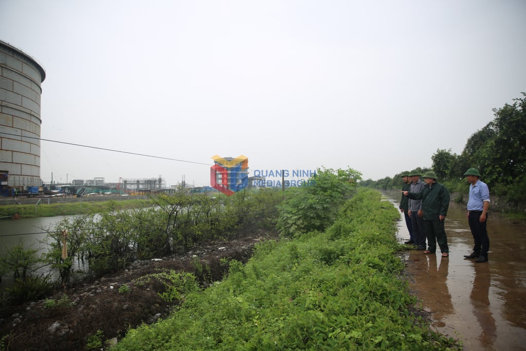
Implementing the direction of the Central leadership and the telegrams of the Prime Minister , Quang Ninh province has directed localities and units to continue to deploy storm response tasks, arrange forces and means to coordinate flexibly, ensuring good communication when situations arise. The province has also established 3 working groups to inspect storm response work in localities, providing direct, close and synchronous direction.
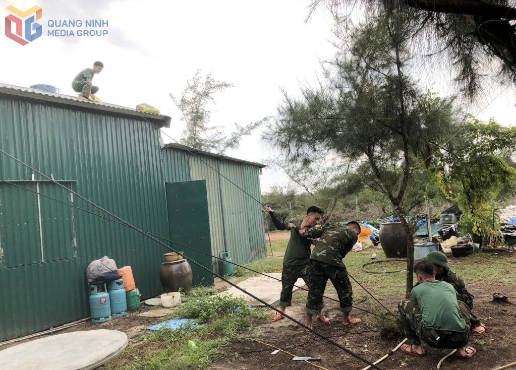
Specifically, regarding the preparation of forces, 1,228 officers and soldiers and disaster prevention shock troops, 27 cars of various types, 10 ships, 32 boats were mobilized. The combined forces of units of Military Region III were 1,435 officers and soldiers, 41 cars, 8 ships, 27 boats, 6 special vehicles. All were on duty at assigned areas, ready to carry out tasks when required.
In addition, the forces have also called for boats and safe aquaculture areas. Currently, a total of 111 passenger ships and 375 tourist ships have returned to shelters since the afternoon of July 20. In addition, 275 offshore fishing vessels have returned to safe shelters, of which 20 are anchored in other provinces, 255 are anchored in the province; over 4,000 nearshore vessels operating along the coast in the "morning departure, afternoon return" manner have anchored at fishing ports, sheltered bays in the province and fishing port areas in Hai Phong. The province has organized a sea ban from 2:00 p.m. on July 20, 2025.
The province has 7,708 aquaculture facilities (including 800 offshore aquaculture facilities) that have been reinforced; 7,590 people have been brought ashore since noon on July 19 (priority given to women, the elderly, and children).
Localities continue to review areas at high risk of flooding, landslides, and old, degraded apartment buildings to plan for evacuation when situations arise. The whole province has 2,528 houses at risk of flooding and landslides; the People's Committees of localities have informed and developed evacuation plans when there is a risk and notified households to proactively implement. 355 urban trees have been trimmed, signs and telecommunication poles have been reinforced to ensure safety.
The provincial Border Guard organized the firing of 24 storm warning flares from the evening of July 19, 2025 at the Co To and Ngoc Vung Border Guard stations and continued to do so until the last news about the storm was received.
Regarding tourists on island routes, there are still 47 tourists who want to stay on the islands (Co To: 39 guests, Van Don: 8 guests), the locality has directed tourism businesses to ensure the living needs of guests.
Regarding irrigation works, by July 21, 2025, the capacity of large reservoirs in the area reached about 68% of the design capacity (227/330 million m3), some reservoirs have proactively lowered the water level. The reservoirs are operating normally, the reservoir management unit has organized 100% of the staff to be ready to regulate in case of major floods; 5 pumping stations (159,000 m3/hour) in the Dong Trieu area (old) are ready to operate when required. The dike routes are not currently under construction.
Communes, wards and special zones continue to provide information about storms and heavy rain to the community to deploy prevention and response measures; coordinate with local forces; establish working groups to propagate and support the evacuation of people to safe places; ensure security and order in evacuation areas and shelters. Complete solutions to ensure safety for construction works, coastal tourist and entertainment areas; areas at risk of flooding and landslides; dredge urban drainage systems, canals, rivers and streams; deploy forces and means to guard at spillways, rivers and streams, areas at risk and search and rescue when situations arise.
Coal industry units have prepared vehicles and human resources to respond to heavy rain situations at mines and tunnels operated by industry units and are ready to support localities when requested.
According to the assessment of the Hydrometeorological Station, from the evening of July 21, the sea area of Co To, Tran Island; Vinh Thuc commune, Cai Chien commune, Van Don special zone will gradually increase to level 6-7, then increase to level 8-9, the area near the storm center will be level 10-11, gusting to level 14; the western region of the province will be level 6-7, gusting to level 8-9. The common rainfall is 80-120mm, in some places reaching over 150mm.
Therefore, the Provincial Steering Committee for Disaster Prevention, Search and Rescue and Disaster Prevention and Control requires localities and units to continue to direct the review and prepare plans to evacuate households in dangerous areas, especially along rivers, streams, coastal areas, areas at high risk of landslides, flash floods, and deep flooding to safe places; arrange forces, materials, and means to overcome incidents, ensuring smooth traffic on main traffic routes, especially in urban areas.
Source: https://baoquangninh.vn/huy-dong-moi-nguon-luc-ung-pho-bao-so-3-3367769.html


![[Photo] National Assembly Chairman Tran Thanh Man visits Vietnamese Heroic Mother Ta Thi Tran](https://vphoto.vietnam.vn/thumb/1200x675/vietnam/resource/IMAGE/2025/7/20/765c0bd057dd44ad83ab89fe0255b783)


Comment (0)