
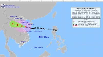
Detailed developments on the direction and speed of super typhoon No. 3 YAGI
On the afternoon of September 5, Mr. Mai Van Khiem, Director of the National Center for Hydro-Meteorological Forecasting, announced the development of storm No. 3 (storm YAGI). Accordingly, on the evening of September 1, storm YAGI formed in the sea off the central Philippines. On the morning of September 2, storm YAGI crossed the northern area of Luzon Island (Philippines) and entered the eastern area of the East Sea, becoming storm No. 03 in 2024.

Details of each point of heaviest rain when storm No. 3 makes landfall in our country: Will it be a record value?
On the afternoon of September 5, storm No. 3 was in the northern part of the North East Sea, about 500km east of Hainan Island (China). The storm intensity was level 16 (super typhoon level), gusting over level 17.
"This is a very strong storm with a wide circulation. The area with strong winds of level 8 has a radius of about 250km, the area with strong winds of level 10 is about 150km, and the area with strong winds of level 12 is about 80km around the center of the storm.
International storm forecasting centers all agree that storm No. 3 will continue to maintain super storm level (level 16 or higher) until it reaches the eastern coastal area of Hainan Island. After that, storm No. 3 will move into the Gulf of Tonkin at level 13-14, gusting to level 16, and when it affects the mainland, its intensity will likely be level 9-12, gusting to level 13-14," said Mr. Mai Van Khiem.
Typhoon YAGI is expected to have terminal winds of force 12 (70 kts) just before making landfall near Vietnam, then wind speeds are expected to decrease rapidly after making landfall. Although the storm's wind speeds are forecast to decrease rapidly after making landfall, the storm's circulation will bring widespread heavy rain, even if the eye of the storm does not make landfall in Vietnam.
Storm No. 3 is forecast to remain at level 16, gusting to level 17, until it moves into the waters east of Hainan Island.
It is forecasted that around the night of September 6, storm No. 3 will pass the area north of Hainan Island and move into the Gulf of Tonkin, then directly affect all coastal provinces from Quang Ninh to Thanh Hoa; around the afternoon and night of September 7, the storm will move inland in the northern provinces, then move to the northwest, weaken into a low pressure area and gradually dissipate.
From the afternoon of September 6, the Gulf of Tonkin (including Bach Long Vy and Co To island districts) will have winds gradually increasing to level 6, then increasing to level 8-10, the area near the storm center will have winds of level 13-14, gusting to level 17; the sea will be very rough.
The sea area in the North East Sea has waves 7.0-9.0m high, near the storm center 10.0-12.0m. The sea is very rough.
From the night of September 6, in the Gulf of Tonkin (including Bach Long Vy and Co To island districts), waves were 2.0-4.0m high, then increased to 3.0-5.0m, and 6.0-8.0m high near the storm's eye.
Early morning of September 7, coastal waters from Quang Ninh to Thanh Hoa provinces had waves 2.0-3.0m high, later increasing to 2.0-4.0m, near the storm center 3.0-5.0m.
Coastal provinces from Thanh Hoa to Quang Ninh need to be on guard against storm surges of 0.5-1.8m: Quang Ninh from 1.5-1.8m; Hai Phong and Thai Binh from 1.2-1.5m; Nam Dinh and Ninh Binh from 0.8-1.2m; Thanh Hoa: 0.5-1.0m.
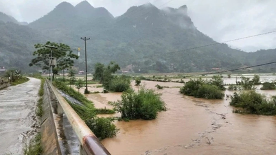
Many provinces face widespread floods and inundation when super typhoon No. 3 YAGI makes landfall
Due to the influence of storm No. 3, from early morning on September 7, coastal areas of provinces from Quang Ninh to Thanh Hoa have winds gradually increasing to level 6-7, then increasing to level 8-9, areas near the storm center (Quang Ninh, Hai Phong City, Thai Binh, North Nam Dinh) level 10-12, gusting to level 14; areas deep inland in the Northeast have strong winds of level 6-8, gusting to level 9-11.
From the night of September 6 to the morning of September 9, in the provinces of Quang Ninh, Hai Phong, Lang Son, Ha Giang, Phu Tho, Hoa Binh, the Northern Delta region (including the capital Hanoi) and Thanh Hoa, there will be heavy to very heavy rain with average rainfall of 150-350mm, locally over 500mm. Other places in the Northeast will have average rainfall of 100-150mm.
From the afternoon of September 7 to the end of September 8, the Northwest region will have heavy rain, some places will have very heavy rain with common rainfall of 100-200mm. Particularly in Lao Cai, Yen Bai, Son La provinces, it will be 150-250mm, locally over 350mm.
It is forecasted that in the Northern and North Central provinces, there may be a flood, widespread flooding in the Northern region and Thanh Hoa. From September 7-10, there will be a flood on rivers and streams in the Northern region and Thanh Hoa. Warning of the risk of widespread flooding in mountainous provinces, the Northern midland plains, urban areas, especially in the provinces of Quang Ninh, Hai Phong, Lang Son, Cao Bang, Ha Giang, Yen Bai, Bac Can, Thai Nguyen.
Experts emphasize that heavy rain, concentrated in a short period of time, is a special danger of flash floods and landslides, concentrated in the mountainous and midland areas of the North, Thanh Hoa and Nghe An. From the night of September 6 to September 8, special attention should be paid to the following districts at very high risk:
Quang Ninh (12 districts/towns): Dong Trieu Town, Quang Yen Town, Mong Cai City, Cam Pha City, Uong Bi City, Ha Long City, Ba Che, Van Don, Tien Yen, Hai Ha, Dam Ha, Binh Lieu.
Lang Son (11 districts): Huu Lung, Binh Gia, Loc Binh, Van Lang, Cao Loc, Van Quan, Chi Lang, Bac Son, Dinh Lap, Lang Son city.
Bac Kan (6 districts): Ngan Son, Na Ri, Bach Thong, Cho Don, Cho Moi, Bac Kan city.
Thai Nguyen (9 districts): Dinh Hoa, Phu Luong, Vo Nhai, Dong Hy, Phu Binh, Pho Yen Town, Song Cong City, Thai Nguyen City, Dai Tu.
Bac Giang (8 districts): Bac Giang City, Luc Nam, Tan Yen, Hiep Hoa, Yen The, Son Dong, Luc Ngan, Lang Giang.
Vinh Phuc (5 districts): Song Lo, Lap Thach, Tam Dao, Binh Xuyen, Phuc Yen.
Hoa Binh (11 districts): Luong Son, Da Bac, Kim Boi, Lac Son, Cao Phong, Mai Chau, Hoa Binh City, Ky Son, Lac Thuy, Tan Lac, Yen Thuy.
Phu Tho (9 districts): Cam Khe, Doan Hung, Ha Hoa, Phu Ninh, Tan Son, Thanh Ba, Thanh Son, Thanh Thuy, Yen Lap.
Tuyen Quang (6 districts): Son Duong, Chiem Hoa, Yen Son, Tuyen Quang city.
Yen Bai (9 districts): Luc Yen, Yen Binh, Van Yen, Tran Yen, Van Chan, Mu Cang Chai, Tram Tau, Yen Bai City, Nghia Lo Town.
Son La (8 districts): Son La City, Mai Son, Yen Chau, Muong La, Moc Chau, Van Ho, Phu Yen, Bac Yen.
Lai Chau (3 districts): Tam Duong, Tan Uyen, Than Uyen.
Lao Cai (4 districts): Bat Xat, Sa Pa, Van Ban, Bao Yen.
Thanh Hoa (10 districts): Lang Chanh, Thuong Xuan, Quan Hoa, Muong Lat, Nhu Xuan, Quan Son, Ba Thuoc, Cam Thuy, Ngoc Lac, Thach Thanh.
Nghe An (4 districts): Que Phong, Quy Chau, Tuong Duong, Ky Son.
In case the subtropical high pressure tongue quickly retreats to the East (in this case, there is a 20% probability), Storm No. 3 will move more to the North, passing through the Leizhou Island area, affecting the Guangxi Province (China), in Vietnam, the main affected area will be the Gulf of Tonkin, the mainland will be Quang Ninh and Hai Phong provinces. The impacts of rain and wind will be significantly reduced.
Storms with similar paths to storm number 3 (storm YAGI)
Storm No. 7 in 2016 (Sarika)
The direction of movement is more northerly than storm number 3. The intensity when near Hainan Island (China) is level 14 (2-3 levels lower than storm number 3). The intensity when entering the Gulf of Tonkin is level 11-12.
Coastal provinces from Quang Ninh to Nam Dinh have also observed strong winds of level 6-7, gusting to level 8. Total rainfall is insignificant. In the Northeastern provinces, rain occurred from 7:00 p.m. on October 18 to 1:00 a.m. on October 20, commonly around 30-70mm, some places had very heavy rain of over 100mm.
Storm No. 2 of 2014 (Rammasun)
The direction of movement is more northerly than storm number 3. The intensity when near Hainan Island (China) reaches level 14-15 (1-2 levels lower than storm number 3). The intensity when entering the Gulf of Tonkin reaches level 14-15. Strong winds of level 8-9, gusts of level 10 in Quang Ninh province; in Lang Son and Bac Giang provinces, strong winds of level 6-7, gusts of level 8; in Hai Phong, Bac Ninh and Hai Duong provinces, strong winds of level 6-7.
Total rainfall from July 19-21 in the Northern Delta and midland areas is generally 40-70mm, in some places 80-120mm; in the Northern mountainous provinces it is generally 100-300mm, in some places over 300mm.
Storm No. 3 in 2014 (Kalmaegi)
The direction of movement is slightly more north than storm number 3. The intensity when near Hainan Island (China) is level 13 (2-3 levels lower than storm number 3). The intensity when entering the Gulf of Tonkin is level 12-13.
In Quang Ninh and Hai Phong, there are strong winds of level 8-9, gusting to level 10-11; in Cao Bang, Lang Son, Bac Ninh provinces and the Northern Delta, there are strong winds of level 6-7, gusting to level 8-9, with some places gusting to level 10. Total rainfall from 13:00/16-13:00/18/9 in the northern mountainous provinces is generally 50-150mm, with Hoang Su Phi (Ha Giang) alone being 204mm.
Source: https://danviet.vn/chi-tiet-tung-diem-mua-lon-nhat-khi-bao-so-3-vao-dat-lien-nuoc-ta-lieu-co-ghi-nhan-gia-tri-ky-luc-20240905212338993.htm


![[Photo] Closing of the 13th Conference of the 13th Party Central Committee](https://vphoto.vietnam.vn/thumb/1200x675/vietnam/resource/IMAGE/2025/10/08/1759893763535_ndo_br_a3-bnd-2504-jpg.webp)


Comment (0)