
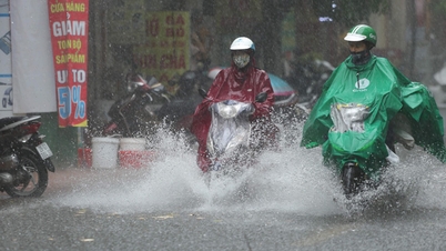
From last night to this morning, the North, Thanh Hoa and northern Nghe An had scattered rain, some places had heavy rain. The National Center for Hydro-Meteorological Forecasting recorded rainfall from 7pm yesterday to 3am today in some places over 80mm such as: Ho Thau 1 station (Tuyen Quang) 88mm, Chieng Noi station (Son La) 90mm, Giao An station (Thanh Hoa) 123mm, Tam Hop 2 station (Nghe An) 154mm. This rainfall has decreased by half compared to the previous day.
 |
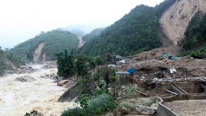
Using rescue boats to supply people in flooded areas in Lao Cai province. |
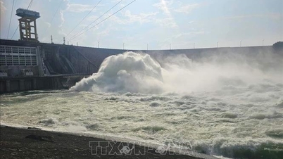
Rain has decreased, but the accumulated rainfall from the previous two days is large, combined with upstream floods and hydropower plant discharges, so floods on Lo River (Tuyen Quang), Cau River, Thuong River (Bac Ninh), and Thai Binh River (Hai Phong) are rising.
The meteorological agency recorded at 7:00 a.m. today, the water level of Thao River at Yen Bai station was 0.8 m above alert level three; Lo River at Tuyen Quang was 0.7 m below alert level three; Luc Nam River was 0.3 m below alert level three; Cau River at Dap Cau was above alert level two; Thuong River at Phu Lang Thuong was 0.1 m above alert level two.
In the Northern Delta, the flood on the Thai Binh River at Pha Lai station is 4.4 m, 0.4 m above the first alarm level; on the Red River at Hanoi station is 8.76 m, 0.74 m below the first alarm level.
In the North Central region, flood on the Ma River (Thanh Hoa) at Giang is at the second alarm level of 0.31 m; the downstream of the Ca River (Nghe An) is fluctuating at the peak of the second alarm level, both receding 0.3-0.5 m compared to yesterday afternoon.
It is forecasted that in the next 12 hours, the flood downstream of Ca River at Nam Dan will fluctuate at its peak, the flood on Ma River and Luc Nam River will drop below alert level two, and on Thao River will drop below alert level three. The flood on Lo, Cau, Thuong and Thai Binh Rivers will continue to rise above alert level three.
In the next 12-24 hours, the flood in the lower reaches of the Ca River will drop below level two, the Luc Nam and Thao Rivers will drop to level one, the Ma River will continue to drop and stay above level one. The flood in the Lo River will peak at level three, the Cau, Thuong and Thai Binh Rivers will continue to rise to level three and above level three.
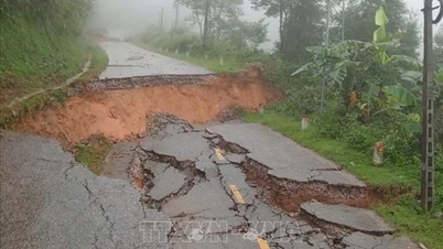
Rising river water, especially at alert levels two and three (the highest is alert level three), will cause flooding in low-lying areas along the river, putting pressure on the dyke and embankment systems, affecting activities such as water transport, aquaculture, agricultural production, and people's lives.
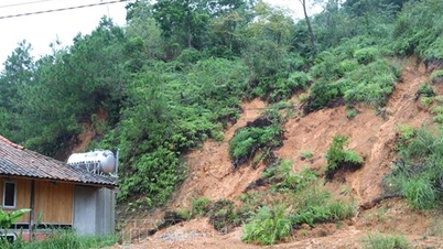
Based on rainfall, rain forecast and soil moisture, the National Center for Hydro-Meteorological Forecasting warns of a very high risk of landslides and flash floods in 23 communes and wards of Tuyen Quang province, down 46 units compared to a day ago.
In addition, 298 other communes of the provinces and cities of Cao Bang, Son La, Dien Bien, Lai Chau, Lao Cai, Thai Nguyen, Lang Son, Quang Ninh, Bac Ninh, Phu Tho, Thanh Hoa, Nghe An, Ha Tinh, and Quang Tri were also affected.
Source: https://baobacninhtv.vn/lu-cac-song-mien-bac-dang-len-postid427806.bbg
![[Photo] Hanoi morning of October 1: Prolonged flooding, people wade to work](https://vphoto.vietnam.vn/thumb/1200x675/vietnam/resource/IMAGE/2025/10/1/189be28938e3493fa26b2938efa2059e)


![[Photo] Panorama of the cable-stayed bridge, the final bottleneck of the Ben Luc-Long Thanh expressway](https://vphoto.vietnam.vn/thumb/1200x675/vietnam/resource/IMAGE/2025/9/30/391fdf21025541d6b2f092e49a17243f)
![[Photo] The 1st Congress of Phu Tho Provincial Party Committee, term 2025-2030](https://vphoto.vietnam.vn/thumb/1200x675/vietnam/resource/IMAGE/2025/9/30/1507da06216649bba8a1ce6251816820)
![[Photo] President Luong Cuong receives President of the Cuban National Assembly Esteban Lazo Hernandez](https://vphoto.vietnam.vn/thumb/1200x675/vietnam/resource/IMAGE/2025/9/30/4d38932911c24f6ea1936252bd5427fa)


Comment (0)