


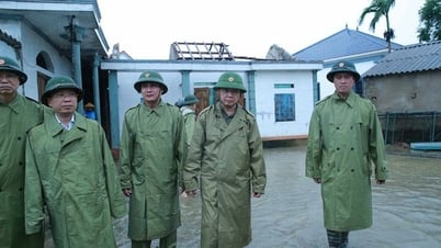
Deputy Prime Minister Tran Hong Ha chaired the fourth meeting of the Steering Committee for Storm Response No. 5, after the storm made landfall in Ha Tinh and Nghe An on the evening of August 25 - Photo: VGP/Minh Khoi
A quick report from the Ministry of Agriculture and Environment said the storm's circulation is wide, covering almost the entire East Sea, causing widespread rain from the North to the North Central region.
As it moved closer to the Central Coast, the storm slowed down, at times standing still for more than 3 hours, then after making landfall it continued to move very slowly, causing its stay on land to last for about 10 hours (from 6:00 p.m. on August 25 to 4:00 a.m. on August 26). This caused strong winds to last longer, increasing the danger level.
On the afternoon of August 25, storm No. 5 made landfall in the Nghe An - Ha Tinh area with a magnitude of 11-12, gusting to level 13. By early morning of August 26, the storm moved to Central Laos and weakened into a tropical depression.
Due to the storm's influence, from August 24 to the morning of August 26, Ha Tinh had very heavy rain, commonly from 200-450mm; Thanh Hoa and Nghe An had rain of 200-400mm; Quang Tri from 150-300mm; the North had rain of 100-200mm; some stations had very heavy rain such as: Thuong Tuy (Ha Tinh) 673mm, Cam Xuyen (Ha Tinh) 599mm, Ky Phong (Ha Tinh) 589mm, Van Xuan (Thanh Hoa) 534mm, Hua Na (Nghe An) 464mm.
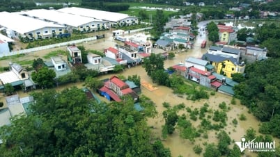
Heavy rain caused flooding on the Ma River (Thanh Hoa) at Cam Thuy station at 19.31m, 0.31m on BĐ2, 4.0m at Giàng station (at BĐ1) and is currently rising; flooding on the upper reaches of the Ca River (Nghe An) at Thach Giam is rising to 66.98m, 0.98m on BĐ1; on the Gianh River (Quang Tri) has peaked on BĐ1 and is now falling.
It is forecasted that by 4:00 p.m. on August 26, the tropical depression will weaken and gradually dissipate. From early morning on August 26 to morning on August 27, the midlands and deltas of the North, Son La, and Lao Cai will have widespread rain of 60-120mm, locally over 200mm.
On August 26, from Thanh Hoa to Ha Tinh, there will be 50-100mm of rain, locally over 150mm. There is a high risk of landslides in the mountainous areas of the North and from Thanh Hoa to Ha Tinh.
Floods on rivers in Thanh Hoa and Nghe An continue to rise. On the Buoi River, it rises above level 2-3. On the Ma River, at Cam Thuy station, it rises to level 2-3, and at the downstream Giang station, it rises to level 1-2. On the Ca River (Nghe An), at Con Cuong station, it rises 29.75m, 0.5m above level 3, and at the downstream Nam Dan station, it falls below level 1. Flood warning on the Hoang Long River (Ninh Binh) rises to level 1-2.
By the morning of August 26, key locations of weak dikes, irrigation and hydroelectric reservoirs were basically safe; infrastructure works, telecommunications, traffic works, etc. were still operating during the storm (without widespread disruptions like in storm Yagi).
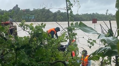
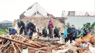
According to initial reports from localities, as of 6:00 a.m. on August 26, storm No. 5 killed 3 people (Nghe An 1, Ha Tinh 1, Ninh Binh 1), injured 10 people (Phu Tho 1, Ha Tinh 5, Quang Tri 4); 7 houses collapsed (Ha Tinh); 6,802 houses had their roofs blown off or were damaged (Ha Tinh: 6,340); 3,094 houses were flooded (Thanh Hoa: 1,935, Ha Tinh 1,129).
The storm flooded 28,814 hectares of rice (Nghe An 4,443 hectares, Ha Tinh 20,802 hectares, Quang Tri 2,108 hectares), 2,221 hectares of crops (Nghe An 524 hectares, Ha Tinh 1,673 hectares), 2,202 hectares of fruit trees (Ha Tinh) and broke 17,968 trees (Thanh Hoa 241, Nghe An 1,914, Ha Tinh 15,813).
There are currently 6 landslides on rural traffic routes (Thanh Hoa 3, Quang Tri 3) and local flooding of some traffic routes, underground overflow at 11 locations in Thanh Hoa (causing traffic jams) and in 7 communes of Quang Tri province...
The power system recorded 3 500KV grid incidents (2 incidents have been resolved); 4 220KV grid incidents (completed); 331 broken power poles (Thanh Hoa 28, Nghe An 225, Ha Tinh 22, Thai Nguyen 17, Phu Tho 4); 1,273,479 customers lost power.
Currently, localities are organizing to overcome the consequences and continue to review and synthesize damage data.
The Government Portal will continue to update information.
Minh Khoi
Source: https://baochinhphu.vn/pho-thu-tuong-tran-hong-ha-chu-tri-hop-chi-dao-khac-phuc-hau-qua-bao-so-5-ung-pho-voi-mua-lu-sau-bao-102250826072413942.htm
![[Photo] Brilliant red of the exhibition 95 years of the Party Flag lighting the way before the opening](https://vphoto.vietnam.vn/thumb/1200x675/vietnam/resource/IMAGE/2025/8/27/e19d957d17f649648ca14ce6cc4d8dd4)


![[Photo] Prime Minister Pham Minh Chinh receives CEO of Samsung Electronics](https://vphoto.vietnam.vn/thumb/1200x675/vietnam/resource/IMAGE/2025/8/26/373f5db99f704e6eb1321c787485c3c2)
![[Photo] Prime Minister Pham Minh Chinh chairs meeting of National Steering Committee on International Integration](https://vphoto.vietnam.vn/thumb/1200x675/vietnam/resource/IMAGE/2025/8/26/9d34a506f9fb42ac90a48179fc89abb3)


Comment (0)