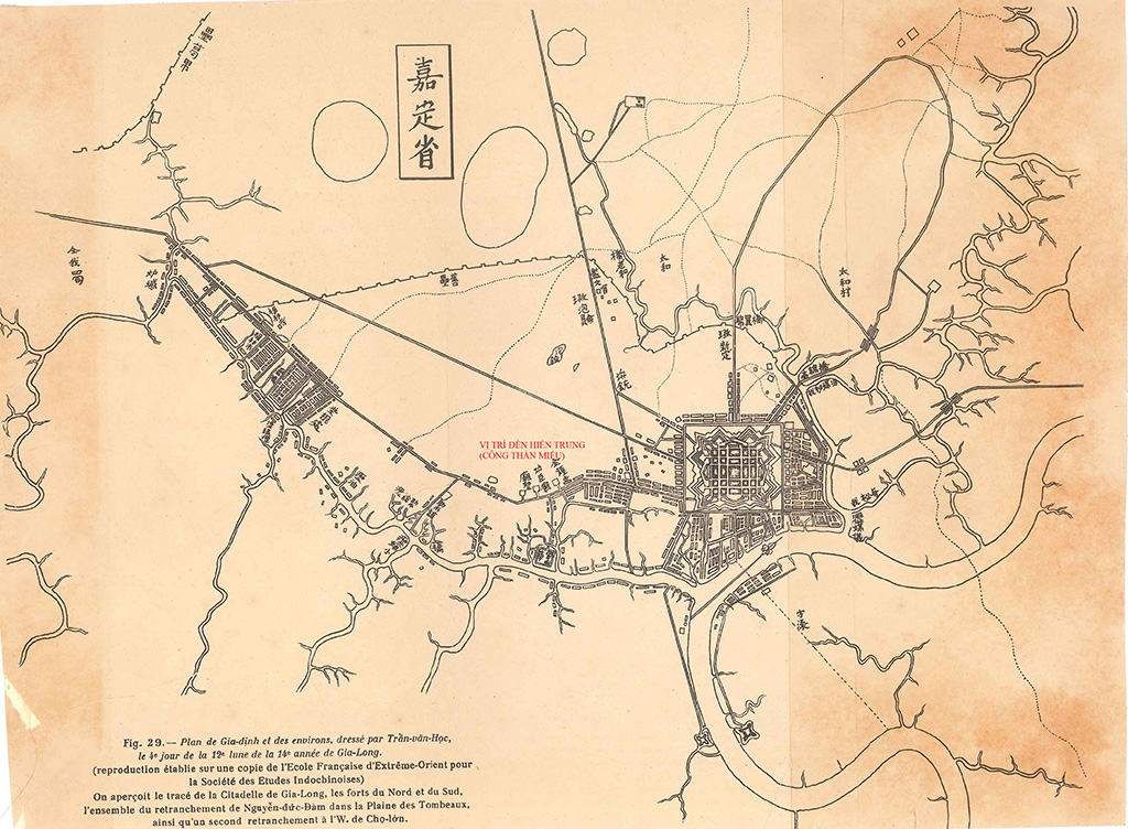
Map by Tran Van Hoc, 1815
The Saigon-Ben Nghe area became a geopolitical entity, a large city as it is today, having undergone many ups and downs in its development – this article will focus only on its canal and drainage system.

A drawing of the ancient Gia Dinh Citadel in the 1815 map by Tran Van Hoc.
PHOTO: LUONG CHANH TONG ARCHIVE
In 1700, General Lao Cam, a subordinate of Nguyen Huu Canh, built the Lao Cam rampart west of Saigon to protect the capital of Gia Dinh (Tran Van Hoc's map shows the Cat Ngang rampart ). In 1772, General Nguyen Cuu Dam built the Ban Bich rampart to protect all three cities of Saigon - Ben Nghe - Gia Dinh.
In 1790, Nguyen Anh built the large Bat Quai citadel on Tan Khai hill towards Ben Nghe. Tran Van Hoc is considered the architect responsible for building the citadel and renovating the streets of Ben Nghe.
In 1815, Tran Van Hoc published a map of Gia Dinh citadel covering a fairly large area with clear place names, especially depicting all the major canals, rivers, and swamps. These included the large Ben Nghe River (Saigon River), Ben Nghe Canal, Saigon Canal (Tau Hu Canal), Lo Gom Canal, Ben Cui Canal, Ong Lon Canal, Ong Be Canal, Thi Nghe Canal, Nhieu Loc Canal, Mu Tri Junction (later Cau Bong Canal), Moi Junction (later Van Thanh Canal), Dau Canal, Cho Quan Canal, Bau Tron... Within the smaller area of what is now District 1, Tran Van Hoc clearly depicted Ben Thanh Canal (Nguyen Hue Canal), Cay Cam Canal (Le Loi Canal), Cau Sau Canal (Ham Nghi Canal), Cau Ong Lanh Canal, Cau Muoi Canal, Cau Kho Canal...
In 1819, the Ruột Ngựa (An Thông Hà) canal was opened, running straight from Bà Thuông Bridge to Cát Canal, to facilitate water transport to the six provinces.
In 1835, following the Le Van Khoi rebellion, Minh Mang ordered the demolition of the Bat Quai citadel and the construction of a smaller Gia Dinh provincial citadel nestled in the northeastern corner of the old citadel's site. The new citadel was located further from the Saigon River and near the Thi Nghe canal.
In early 1859, the Franco-Spanish coalition withdrew from Da Nang to occupy and destroy Gia Dinh citadel. All military operations at that time were conducted via rivers and canals.
In 1862, Hue was forced to sign a "peace treaty" to reimburse war costs to the French-Spanish coalition and cede colonial rule to France over the three eastern provinces of Southern Vietnam: Bien Hoa, Gia Dinh, and Dinh Tuong.
Coffyn's 1862 map and Saigon map of 1867
On April 30, 1862, Colonel Coffyn, an engineer, submitted a project to build Saigon for 500,000 inhabitants, as instructed by Admiral-Governor Bonard. Accompanying the plan were fairly clear explanations of the architectural and spatial planning. The city, built in a Western style, covered approximately 2,500 hectares (25 km²) and was situated between the Thi Nghè Canal, the Saigon River, the Bến Nghé Canal, and the newly dug Vành Đai Canal (canal de ceinture), which started from Cây Mai Pagoda near the Bến Nghé Canal, looped around the Tập Trận field (equivalent to the Bán Bích rampart built by Nguyễn Cửu Đàm in 1772), and then connected to the Thi Nghè Canal.

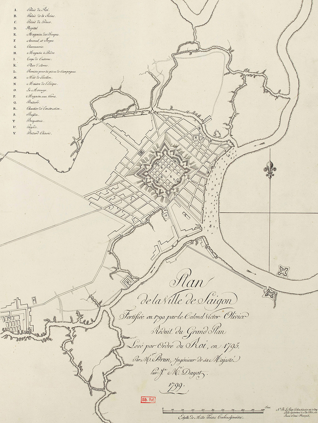
The map of Saigon, drawn by the royal engineer Le Brun in 1795, shows the Saigon citadel, completed in 1790 by the military engineer Olivier de Puymanel.
PHOTO: National Library of France - ARCHIVES OF NGUYEN QUANG DIEU
Among the many problems to be solved for a new city, one is the issue of stormwater and wastewater drainage. Coffyn writes: "Storage of stormwater and wastewater in a city is always a difficult problem. Here, that difficulty is more serious than anywhere else, because the ground level of Saigon is not much higher than the water level of the rivers and canals, so it is not possible to lay ordinary sewer pipes. Instead, sewer pipes with automatic opening and closing gates must be constructed (des égouts à vannes automatrices)"...
"Perhaps, following Admiral Charner's suggestion, we could emulate the water reservoir in Calcutta (India), that is, dig a large lake in the center, from which four drainage channels branch off to draw water from the Ben Nghe Canal, Thi Nghe Canal, Saigon River, and Ring Canal. These channels would be sealed with gates (écluses) that allow for the installation of water discharge pumps (chasse d'eau) into the pipes, and simultaneously allow water to flow into the lake through the drainage channels when the tide is high. In this way, twice a week, we could allow water to flow in and out through the drainage pipes. We should design slopes for streets, riverbanks, and boulevards to ensure the drainage of rainwater, well water, and fountains through drainage ditches along the sidewalks" (!).
The Coffyn Project was indeed a good idea, but it was considered an illusion given the circumstances at the time and was therefore unfeasible.
On January 3, 1865, a decree was issued defining the boundaries of Saigon within the area between Thi Nghe Canal, Saigon River, Ben Nghe Canal, the new Ong Lanh Bridge (Boresse) road, to the Six-Way Intersection along Thuan Kieu Street (Cach Mang Thang 8 Street), clearly showing Chasseloup-Laubat Street (Nguyen Thi Minh Khai Street) and straight to Thi Nghe Canal. The Public Works Department's 1867 Saigon City Map accurately depicted the boundaries as per the above decree. The inner-city canals also matched the Saigon Port map. Furthermore, this map included the Cau Ong Lanh Canal, Cau Muoi Canal, and the headwaters of the Cau Kho Canal located in the swamp near Ong Lanh Bridge (the French map labeled it Marais Boresse). (to be continued)
(Excerpt from *Notes on Vietnamese History and Geography* by the late scholar Nguyen Dinh Dau, published by Tre Publishing House)
Source: https://thanhnien.vn/sai-gon-qua-ban-do-185241011001650673.htm


![OCOP during Tet season: [Article 4] Elevating local products](/_next/image?url=https%3A%2F%2Fvphoto.vietnam.vn%2Fthumb%2F402x226%2Fvietnam%2Fresource%2FIMAGE%2F2026%2F01%2F29%2F1769652810578_2935-z6982071462129_649e82db06fb2f2ea701388b1f5f5b0b-173322_176-185229-202804_457.jpeg&w=3840&q=75)


![OCOP during Tet season: [Part 3] Ultra-thin rice paper takes off.](/_next/image?url=https%3A%2F%2Fvphoto.vietnam.vn%2Fthumb%2F402x226%2Fvietnam%2Fresource%2FIMAGE%2F2026%2F01%2F28%2F1769562783429_004-194121_651-081010.jpeg&w=3840&q=75)

![OCOP during Tet season: [Part 2] Hoa Thanh incense village glows red.](/_next/image?url=https%3A%2F%2Fvphoto.vietnam.vn%2Fthumb%2F402x226%2Fvietnam%2Fresource%2FIMAGE%2F2026%2F01%2F27%2F1769480573807_505139049_683408031333867_2820052735775418136_n-180643_808-092229.jpeg&w=3840&q=75)


Comment (0)