
According to the JMA, as of the morning of May 29, Typhoon Mawar was moving north from the eastern Philippines at a speed of 10 km/h. Wind speed near the center of the storm gradually increased from 162 km/h on the evening of May 28 to 216 km/h on the morning of May 29. If there is no change, Typhoon Mawar will enter the southwestern part of Okinawa Prefecture.
According to the JMA forecast, from May 31, Typhoon Mawar will approach the Sakishima Islands off the main island of Okinawa. The storm zone extends 220 km to the northeast and 150 km to the southwest.
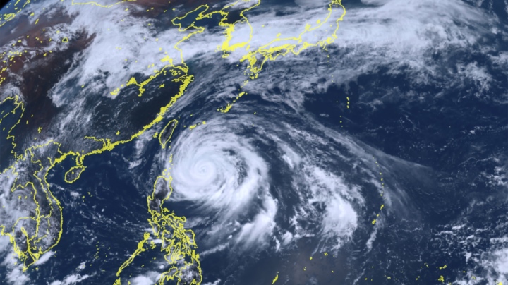
Typhoon Mawar in the Philippine Sea on the morning of May 29. (Photo: AP)
The Japan Meteorological Agency warned that the slow-moving storm could have a lasting negative impact, disrupting atmospheric conditions in many areas across the country.
Waves as high as 5 meters were recorded in the Okinawa Islands and as high as 7 meters near the Sakishima Islands on May 29. Heavy rains are expected in both eastern and western Japan in the coming days. The JMA has advised people to be on guard against landslides and flooding in low-lying areas, rising rivers and lightning.
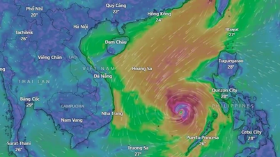
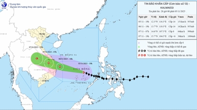
The storm continues to weaken over the Philippine Sea but its area of influence remains quite large, according to the Philippine Atmospheric, Geophysical and Astronomical Services Administration (PAGASA). This is the second storm and the first super typhoon to hit the Philippines in 2023.
Mr. Diego Mariano, Chief of the Office of the Joint Monitoring Center for Civil Defense, said that some local authorities have started evacuating people in flood-prone areas on Luzon Island and the central region of the Philippines to prepare for the storm.
Earlier, Typhoon Mawar swept through the US territory of Guam. This was considered the biggest storm in 20 years in Guam, causing widespread power outages and causing extensive damage to infrastructure there.
Tra Khanh (Source: CGTN)
Useful
Emotion
Creative
Unique
Source


![[Photo] Opening of the 14th Conference of the 13th Party Central Committee](https://vphoto.vietnam.vn/thumb/1200x675/vietnam/resource/IMAGE/2025/11/05/1762310995216_a5-bnd-5742-5255-jpg.webp)


![[Photo] Panorama of the Patriotic Emulation Congress of Nhan Dan Newspaper for the period 2025-2030](https://vphoto.vietnam.vn/thumb/1200x675/vietnam/resource/IMAGE/2025/11/04/1762252775462_ndo_br_dhthiduayeuncbaond-6125-jpg.webp)


Comment (0)