
According to the National Center for Hydro-Meteorological Forecasting, at 1:00 a.m. on September 22, the center of the storm Super Typhoon Ragasa The storm is about 230km east-northeast of Luzon Island (Philippines) and has strengthened. The strongest wind near the center of the super storm is level 16-17 (184-221km/h), gusting over level 17, moving west-northwest at a speed of about 20km/h.
It is forecasted that by 1am on September 23, super typhoon Ragasa will move in a West-Northwest direction, traveling 20km per hour, entering the East Sea, becoming storm number 9 and likely to strengthen. The center of the super typhoon is located in the northeastern sea area of the North East Sea. According to the current forecast, at this time, the super typhoon will reach its maximum level with the strongest wind near the center of the super typhoon reaching level 17, gusting above level 17. Warning of level 4 natural disaster risk in the eastern sea area of the North East Sea.
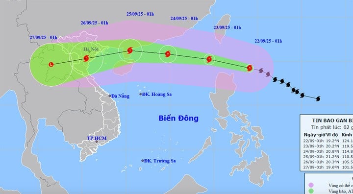
At about 1:00 a.m. on September 24, super typhoon Ragasa was in the northern sea of the North East Sea, about 490 km east of Leizhou Peninsula (China), moving in the West Northwest direction at a speed of 20 km/h. The strongest wind near the center of the super typhoon was level 16-17, gusting above level 17. Warning level 4 natural disaster risk in the northern sea of the North East Sea.
At 1:00 a.m. on September 25, super typhoon Ragasa in the sea east of Leizhou peninsula (China), moving west-northwest at a speed of 15-20 km/h and gradually weakening. The strongest wind near the storm center is level 14-15, gusting to level 17. Warning level 4 natural disaster risk in the sea northwest of the North East Sea, the sea east of the Gulf of Tonkin.
For the next 72 to 120 hours, Storm No. 9 Ragasa Moving in the West Southwest direction, about 20km per hour, intensity continues to weaken.
"Early morning on September 25, storm No. 9 Ragasa will pass the Leizhou peninsula (China) and move into the Gulf of Tonkin with a strong intensity of level 12-14, gusting to level 15-16. It is forecasted that on September 25, the storm will move into our mainland, focusing on the area from Quang Ninh - Ha Tinh ", meteorological agency commented.
Impact of super typhoon Ragasa, the eastern sea area of the North East Sea gradually increased to level 8-9, then increased to level 10-14, the area near the center of the super typhoon passed level 15-17, gusts above level 17, waves over 10m high, rough seas.
Source: https://baolangson.vn/sieu-bao-ragasa-dat-cap-cuc-dai-17-khi-vao-bien-dong-gay-song-cao-tren-10m-5059622.html


![[Photo] Prime Minister Pham Minh Chinh chairs the first meeting of the Central Steering Committee on housing policy and real estate market](https://vphoto.vietnam.vn/thumb/1200x675/vietnam/resource/IMAGE/2025/9/22/c0f42b88c6284975b4bcfcf5b17656e7)


![[Photo] General Secretary To Lam presents the First Class Labor Medal to the Vietnam National Energy and Industry Group](https://vphoto.vietnam.vn/thumb/1200x675/vietnam/resource/IMAGE/2025/9/21/0ad2d50e1c274a55a3736500c5f262e5)


Comment (0)