
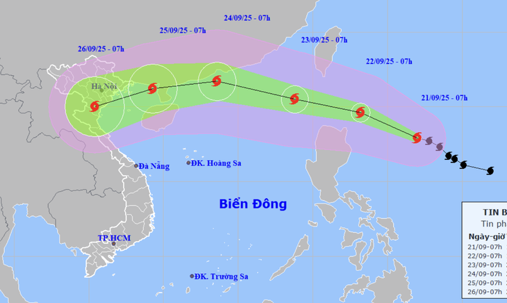
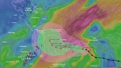
Forecast of the location and trajectory of Typhoon Ragasa at 7:00 AM on September 21st - Photo: NCHMF
According to the National Center for Hydro-Meteorological Forecasting at 7:00 AM on September 21, the center of Typhoon Ragasa was located approximately 520km east of Luzon Island (Philippines).
Typhoon Ragasa may directly affect Northern Vietnam on September 25th and 26th.
The strongest winds near the center of the storm reached level 15 (150-166 km/h), with gusts up to level 16 - an increase of 3 levels compared to 7 am yesterday.
"Typhoon Ragasa, upon entering the East Sea, will reach level 17, a super typhoon. This will be the strongest typhoon in the East Sea since the beginning of the 2025 typhoon season. The typhoon may directly affect Northern Vietnam on September 25th and 26th," the National Center for Meteorological and Hydrological Forecasting stated on the morning of September 21st.
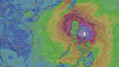
This morning, satellite cloud imagery clearly shows the eye of Typhoon Ragasa, with its symmetrical storm cloud circulation covering a large area of the sea.
The meteorological agency forecasts that in the next 24 hours, Typhoon Ragasa will move in a west-northwest direction at a speed of approximately 15-20 km/h and has the potential to strengthen into a super typhoon.
By 7 AM tomorrow, the super typhoon will be approximately 240km east-northeast of Luzon Island, with its intensity reaching Category 16 (184-201 km/h), and gusts exceeding Category 17.
Over the next 24 to 48 hours, the storm will move west-northwest at a speed of 15-20 km/h, potentially strengthening and entering the South China Sea, becoming the ninth storm of the year.
By 7:00 AM on September 23rd, the super typhoon was located over the sea north of Luzon Island, with its intensity at level 16-17 (184-220 km/h), and gusts exceeding level 17.
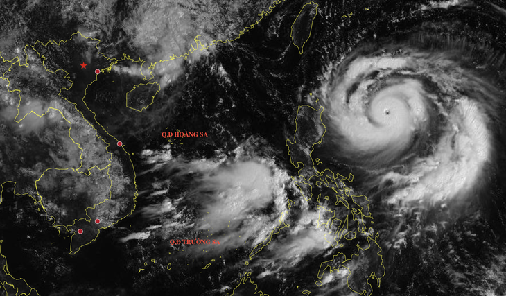
Satellite cloud image of Typhoon Ragasa at 8:50 AM on September 21st - Photo: NCHMF
Level 4 natural disaster risk warning issued in the northern South China Sea.
Over the next 48 to 72 hours, the super typhoon will move west-northwest at a speed of 20-25 km/h, with its intensity likely to decrease.
By 7:00 AM on September 24th, the storm's center was located over the sea off Guangdong province (China), with a strength of level 15 (167-183 km/h), and gusts exceeding level 17.
Over the next 72 to 96 hours, the storm will move west-southwest, passing over Leizhou Island (China) and entering the Gulf of Tonkin.
By 7:00 AM on September 25th, the storm's center was located in the northeastern part of the Gulf of Tonkin, with a strength of level 13 (134-149 km/h) and gusts up to level 16.
Over the next 96 to 120 hours, the storm will move in a west-southwest direction, heading towards the coastal provinces of Northern and North Central Vietnam.
By 7:00 AM on September 26th, the storm's center was over the northern and north-central provinces of Vietnam, with a strength of level 10 (89-102 km/h) and gusts up to level 12.
From September 22nd, the eastern part of the North East Sea will experience increasingly strong winds, reaching levels 8-9, then increasing to levels 10-14, with winds near the storm's center reaching levels 15-17, gusting above level 17, and waves exceeding 10 meters, resulting in extremely rough seas.
Vessels operating in the aforementioned hazardous areas are susceptible to the effects of thunderstorms, tornadoes, strong winds, and high waves.
The meteorological agency issued a level 4 (very high risk) disaster warning for the northern South China Sea region.
Source: https://tuoitre.vn/sieu-bao-ragasa-vao-bien-dong-se-manh-cap-17-kha-nang-anh-huong-truc-tiep-bac-bo-20250921092520911.htm

![[Image] Close-up of the newly discovered "sacred road" at My Son Sanctuary](/_next/image?url=https%3A%2F%2Fvphoto.vietnam.vn%2Fthumb%2F1200x675%2Fvietnam%2Fresource%2FIMAGE%2F2025%2F12%2F13%2F1765587881240_ndo_br_ms5-jpg.webp&w=3840&q=75)


Comment (0)