
Mr. Hoang Phuc Lam, Deputy Director of the National Center for Hydro-Meteorological Forecasting, said that the center of the storm at 4 p.m. on September 27 was at 15.4 degrees North latitude; 113.0 degrees East longitude, about 170 km East Southeast of Hoang Sa special zone. The storm intensity is level 12 (118 - 133 km/h), gusting to level 15, moving in the West Northwest direction, speed about 30 - 35 km/h.
This is a very fast moving storm (nearly twice the average speed), with strong storm intensity and wide range of influence, which can cause combined impacts of many types of natural disasters such as strong winds, heavy rains, floods, flash floods, landslides and coastal flooding.

Forecast at 4:00 p.m. on September 28, the storm will move in the West Northwest direction, at a speed of about 30 km/h, with the possibility of strengthening, the storm will be located at 17.6N - 107.9E, on the sea area of Quang Tri - Hue City, about 140 km east of Quang Tri, storm intensity level 12 - 13, gust level 16, natural disaster risk level 3, the affected area is the North and Central East Sea (including Hoang Sa special zone); the sea area from Ha Tinh to Quang Ngai.
At 4:00 a.m. on September 29, the storm moved in the West Northwest direction, at a speed of 20 - 25 km/h, located at 18.6N-105.3E, on the mainland of Nghe An - North of Quang Tri, storm intensity was level 9, gust level 11, the dangerous area was north of latitude 14.5N; west of longitude 110.0E, disaster risk level was level 4, the affected area was the coastal mainland from Nghe An to North of Quang Tri. Disaster risk level 3 was the sea area west of the North East Sea (including Hoang Sa special zone), from Thanh Hoa to Quang Ngai (including Hon Ngu island, Con Co special zone and Ly Son) and North of Bac Bo Gulf (including Bach Long Vy special zone, Van Don, Co To, Cat Hai and Hon Dau island); mainland area from Ninh Binh to Hue city.
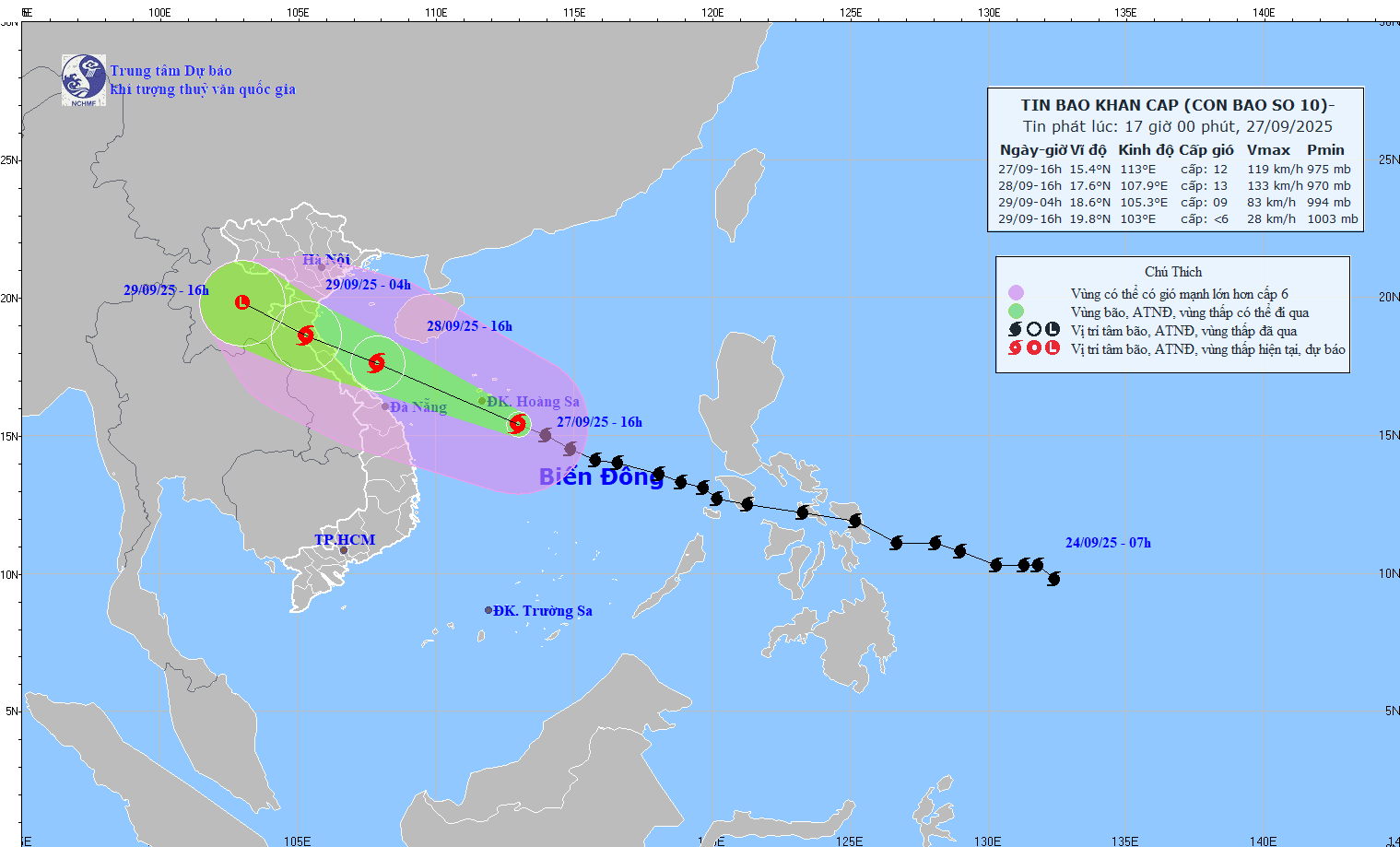
Forecast at 4:00 p.m. on September 29, the storm will move in the West Northwest direction, at a speed of 20 - 25 km/h, weakening into a tropical depression and then a low pressure area, located at 19.8N-103.0E, in the Upper Laos region, storm intensity below level 6, risk level 3, affected areas from Thanh Hoa to Quang Tri (including Hon Ngu island) and the North Gulf of Tonkin (including Bach Long Vy special zone, Van Don, Co To, Cat Hai and Hon Dau island); mainland areas from Ninh Binh to Quang Tri.
“Storm No. 10 is a strong storm, moving very fast (about 30 - 35 km/h, nearly double the normal speed of storms in the East Sea), the storm's intensity is strong, the closer it moves to the shore the stronger the storm's intensity tends to be, the area of influence is wide, it can cause the combined effects of many types of natural disasters such as strong winds, heavy rains, floods, flash floods, landslides and coastal flooding. The storm's circulation is wide, the cloud rim in the west of the storm causes early rain. Although the storm is not as strong at sea and its maximum intensity is not as strong as storm No. 9, because it has not weakened much, the impact on our mainland will be much stronger than storm No. 9,” said Mr. Hoang Phuc Lam.
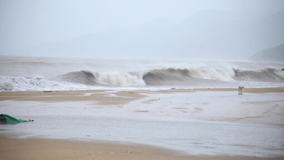
Mr. Hoang Phuc Lam said that from the evening of September 27, the sea area from Thanh Hoa to Quang Ngai (including Hon Ngu island, Con Co special zone and Ly Son) the wind gradually increased to level 6 - 7, gusting to level 8 - 9, waves 3 - 5 m high, rough seas.
From early morning on September 28, the wind increased to level 8 - 9, the area near the storm center passed level 10 - 13, gusting to level 16, waves from 5 - 7 m high, violent sea (extremely destructive, extremely strong waves. Sinking large tonnage ships).
For the Gulf of Tonkin area (including Bach Long Vy, Van Don, Co To, Cat Hai and Hon Dau islands), it is forecasted that from early morning on September 28, the wind will gradually increase to level 6 - 7, then increase to level 8 - 9 (very rough seas, very dangerous for boats), gusting to level 11, waves 3 - 5 m high, very rough seas.
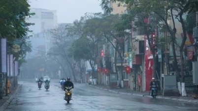
Forecast of the storm's impact on land, regarding strong winds from the afternoon of September 28, on land from Thanh Hoa to Northern Quang Tri, winds will gradually increase to level 6 - 7, then increase to level 8 - 9, near the storm's eye level 10 - 12 (wind force can knock down trees, houses, electric poles, causing very heavy damage), gusts of level 14; coastal areas from Quang Ninh to Ninh Binh, from Southern Quang Tri to Hue City, winds will gradually increase to level 6 - 7 (trees shake, difficult to go against the wind), gusts of level 8 - 9.
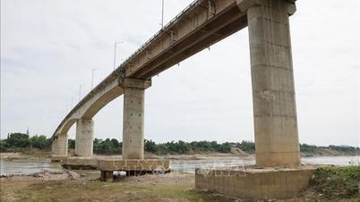
From now until September 30, in the North and the area from Thanh Hoa to Quang Ngai, there is a possibility of widespread heavy rain with total rainfall ranging from 100-300 mm, locally over 450 mm; in the Northern Delta, South Phu Tho and from Thanh Hoa to North Quang Tri, it is common from 200-400 mm, locally over 600 mm.
“The storm moves quickly, the circulation before the storm causes rain from afar, the process of moving inland is not weakened. Heavy rain occurs first, from the evening of September 27. Rain gradually spreads from Quang Ngai to the North. On land, from the afternoon of September 28, the storm wind will gradually strengthen in the Quang Tri - Thanh Hoa area. Therefore, local authorities need to increase propaganda and proactively deploy plans and measures to prevent and avoid storms and tropical depressions; be vigilant, closely monitor forecasts and warnings about storm activities in the East Sea. People need to proactively update forecast information through mass media, strictly follow the recommendations of local authorities on storm prevention measures, evacuation plans, and sea bans...”, Mr. Hoang Phuc Lam advised.
Source: https://baotintuc.vn/xa-hoi/bao-so-10-di-chuyen-nhanh-voi-cuong-do-manh-canh-bao-nhieu-loai-hinh-thien-tai-20250927173441297.htm

![[Photo] Prime Minister Pham Minh Chinh receives Lao Minister of Labor and Welfare Phosay Sayasone](https://vphoto.vietnam.vn/thumb/1200x675/vietnam/resource/IMAGE/2025/11/11/1762872028311_dsc-2246-jpg.webp)

![[Photo] Chu Noodles - the essence of rice and sunshine](https://vphoto.vietnam.vn/thumb/1200x675/vietnam/resource/IMAGE/2025/11/11/1762846220477_ndo_tl_7-jpg.webp)


![Dong Nai OCOP transition: [Article 3] Linking tourism with OCOP product consumption](https://vphoto.vietnam.vn/thumb/402x226/vietnam/resource/IMAGE/2025/11/10/1762739199309_1324-2740-7_n-162543_981.jpeg)


Comment (0)