

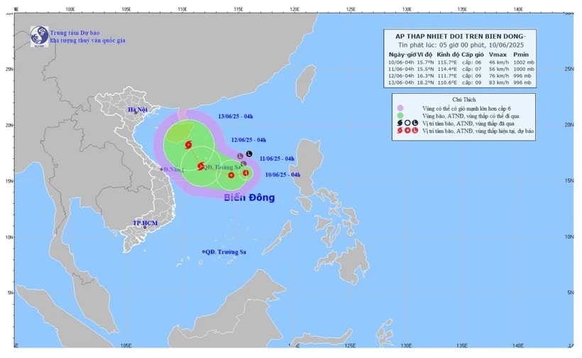
According to the National Center for Hydro-Meteorological Forecasting, on the morning of June 10, the low pressure area in the North East Sea strengthened into a tropical depression.
At 4:00 a.m., the center of the tropical depression was at about 15.7 degrees North latitude; 115.7 degrees East longitude, about 360 km East Southeast of the Hoang Sa area. The strongest wind near the center of the tropical depression was level 6 (39 - 49 km/h), gusting to level 8; the tropical depression moved slowly to the West at a speed of about 5 km/h.
According to the forecast, at 4:00 a.m. on June 11, the tropical depression will be located about 240 km east-southeast of Hoang Sa area with strong winds of level 6-7, gusting to level 9; the tropical depression will move west at a speed of about 5 km/h and is likely to strengthen.
The affected areas are the North East Sea (including the Paracel Islands) and the northern waters of the central East Sea. Disaster risk warning level 3.
At 4:00 a.m. on June 12, the tropical depression moved in a West-Northwest direction at a speed of 10-15 km/h over the Hoang Sa area with strong winds of level 8-9, gusting to level 11 and likely to strengthen into a storm.
The affected areas are the North East Sea (including the Hoang Sa area), the northern sea area between the East Sea and the offshore waters from Hue to Quang Ngai . Disaster risk level 3 warning.
According to the warning of the National Center for Hydro-Meteorological Forecasting, in the next 48 to 72 hours, the storm is likely to change direction and move in a North-Northwest direction at a speed of about 10 km/h and is likely to strengthen.
Due to the influence of the tropical depression, the North East Sea area, the North of the central East Sea area has thunderstorms and strong winds of level 6 - 7, gusts of level 9, rough seas, waves 2 - 4 m high.
Ships operating in the above mentioned dangerous areas are likely to be affected by storms, whirlwinds, strong winds and large waves.
Faced with the complicated developments of the tropical depression, the Ministry of Agriculture and Environment requested that affected provinces and cities closely monitor warning bulletins, forecasts and developments of the tropical depression; notify captains and owners of vehicles and vessels operating at sea to proactively prevent and ensure safety of people and property; maintain communication to promptly handle possible bad situations.
Provinces and cities are ready with forces and means to deploy rescue work when there is a situation, at the same time organize serious on-duty teams, regularly report to the Ministry of Agriculture and Environment (through the Department of Dyke Management and Disaster Prevention and Control).
TH (according to VNA)Source: https://baohaiduong.vn/vung-ap-thap-da-manh-len-thanh-ap-thap-nhiet-doi-413667.html


![[Photo] General Secretary To Lam attends the opening ceremony of the National Achievements Exhibition](https://vphoto.vietnam.vn/thumb/1200x675/vietnam/resource/IMAGE/2025/8/28/d371751d37634474bb3d91c6f701be7f)
![[Photo] National Assembly Chairman Tran Thanh Man holds talks with New Zealand Parliament Chairman](https://vphoto.vietnam.vn/thumb/1200x675/vietnam/resource/IMAGE/2025/8/28/c90fcbe09a1d4a028b7623ae366b741d)


![[Photo] Images of the State-level preliminary rehearsal of the military parade at Ba Dinh Square](https://vphoto.vietnam.vn/thumb/1200x675/vietnam/resource/IMAGE/2025/8/27/807e4479c81f408ca16b916ba381b667)


Comment (0)