
"The Ta Con outpost burned down every year"...
“ On the banks of Hien Luong River, this afternoon I stand and gaze towards the horizon, my eyes filled with love for my homeland, my eyes filled with love for my homeland…” As the car approached Doc Mieu - Con Tien (Gio Linh district), without anyone saying a word, everyone in the group of elderly journalists and veterans from Ha Tinh on this trip to Quang Tri suddenly started singing softly together.
The painful and heroic past resurfaces in memory, especially for journalists and veterans who experienced the arduous days of fighting along both banks of the 17th parallel. Stories of "eating meals on the north bank, fighting on the south bank," of the McNamara electronic barrier, of families separated by the Ben Hai River who would stand longingly on the other side in the evenings, and of famous films like "The 17th Parallel Day and Night" and "Sharing the Same River"... all resonate vividly and passionately.

Journalist Nguyen Khac Hien, who spent four years living and fighting on both sides of the river, pointed to the slope in front of him and said: "It's just an ordinary slope, but during the war, the McNamara electronic barrier – a special barrier system built by the US along the southern side of the temporary military demarcation line (south of the Ben Hai River) from the Gio Linh coast through Gio My hill to Doc Mieu, Con Tien, and up to the Vietnam-Laos border – was there to prevent attacks by our army and people from the North."
Within this defensive system, Doc Mieu was the center of sophisticated reconnaissance equipment, a formidable "all-seeing eye." However, under enemy bombardment and the watchful "all-seeing eye," night after night, troops from the North silently crossed the river into the South, and convoys continued to cross the Truong Son Mountains...

We continued our journey towards Khe Sanh town in Huong Hoa district. The Ta Con airfield and the Highway 9 Victory Museum were peaceful in the afternoon sun. Joining us were veterans from all over, revisiting the old battlefield, and even foreign tourists. As time passed, the scattered enemy planes and tanks throughout the museum area, the photographs, the statistics... were like film reels recounting the heroic achievements of our army and people.
Ta Con, meaning "flat, happy land" in the Van Kieu language, is a hill located next to the Sepon River, 20 km from the Vietnam-Laos border. The US built the Route 9 - Khe Sanh defensive line, along with Con Tien - Doc Mieu, forming a pincer movement to prevent reinforcements and attacks from the North. The enemy concentrated tens of thousands of US and South Vietnamese troops, along with hundreds of aircraft and artillery pieces, here. The US and the Saigon government paid special attention to Route 9 - Khe Sanh, viewing it as the "anchor" on the western side of the entire strategic defense system south of the demilitarized zone. Therefore, the US and South Vietnamese forces focused on building what they considered an invincible stronghold, with a troop strength of over 45,000 (including 28,000 US troops).
The Khe Sanh campaign lasted 170 days, from January 1968 to June 1968. On January 20th, our forces launched an attack to encircle, draw in, pin down, and disperse enemy firepower. They could not have imagined that we had deployed over 200,000 troops and 81 tons of weapons and ammunition to Khe Sanh, tearing apart their defenses. Artillery positions along the Vietnam-Laos front controlled the airspace, preventing them from receiving air reinforcements. They were forced to send troops from Hue, ultimately forcing them to flee. The Khe Sanh campaign ended in complete victory on July 9th, 1968.
Fifty-seven years have passed, and returning to the old battlefield in these April days, veteran Vu Duy Tan (Nam Dinh City, Nam Dinh Province), a former soldier of Company C2, F2, 320th Division, who fought here, couldn't help but feel emotional: "The landscape has changed so much. Every inch of land, every blade of grass here was once plowed up by bombs and bullets; many of my comrades fell to achieve this day of complete victory."

Today, Ta Con is truly a flat, happy land, with the coffee plantations of the Van Kieu and Pa Co people stretching across the hillsides, creating a lush, prosperous landscape. The bustling town of Khe Sanh is vibrant with winding paved roads along the peaceful hillsides.
Vinh Moc Tunnels: Life Underground
On this trip to Quang Tri, we all wanted to revisit the Vinh Moc tunnels. The spirit of "Not an inch will be given up, not a millimeter will be moved" demonstrated the determination of the people of Vinh Linh to hold their ground and protect the land on the north bank of the Ben Hai River. Vinh Moc is a prime example.
Vinh Moc - a village situated on red soil hills near the coast, about 14 km east of Ho Xa town in Vinh Linh district and 6 km north of Cua Tung. When Quang Tri was divided by the 17th parallel, the Vinh Linh area north of the Ben Hai River became a "bombing zone, a cauldron of fire".

Vinh Moc was a key supply point for Con Co Island. The Vinh Moc tunnel system is a deep underground network consisting of three main interconnected tunnels with a total length of over 1,700 meters, built over nearly three years from 1965 to 1967...
This tunnel system is located within a red basalt hill running along the edge of the sea. It was dug higher than sea level and sloped to allow water to drain easily, ensuring that all activities could continue normally even during the rainy season. The tunnel has a total of 13 entrances, including 7 opening to the sea and 6 leading up to the hill. Thanks to the tunnel entrances facing the sea, the underground levels remain cool in summer and warm in winter.

The forces spent approximately 18,000 man-days digging and transporting 6,000 cubic meters of earth and rock to complete this magnificent and unique structure. For nearly 2,000 days and nights inside the tunnels, the people of Vinh Moc, and Vinh Linh in general, created a legend of miraculous resilience. Life continued to flourish here; 17 babies were born, and all aspects of daily life continued. Production to support life, combat, and aid to Con Co Island was maintained despite countless difficulties. The tunnels housed everything: weapons and ammunition depots, food supplies, Party and government offices, military facilities, public works, wells, meeting halls, maternity wards, surgical stations, and communication stations. The Vinh Moc tunnel village was twice awarded the title of Heroic Village by the Party and State, and in 1976 it was recognized as a Special National Monument.
Lacking the resources to explore all the tunnels, our group followed the guide down to tunnel number 3 and emerged at tunnel number 5 after climbing 81 earthen steps. Along the way, we saw many international tourists. They came here to explore the mysteries of life underground for the Vietnamese people, to better understand the strength that led to the victory of an entire nation. Vinh Moc has now become a tourist destination attracting many domestic and international visitors.
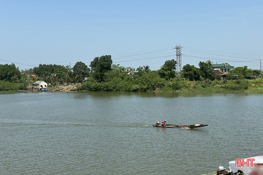
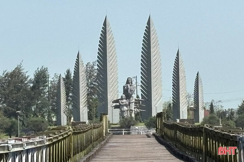
Before returning to Ha Tinh, our group visited the Quang Tri ancient citadel to offer incense to the martyrs, and with a sense of awe, we stepped onto the white line marking the dividing line at the 17th parallel, right in the middle of Hien Luong Bridge. Below the bridge, the Ben Hai River flowed tirelessly towards Cua Tung Sea, its clear blue waters flowing into the sea. On both banks, peaceful houses lay nestled in the midday sun. The "Aspiration for Unification" monument still rose against the deep blue sky. Fifty years since the country was reunified, the pain of division now remains only in memory. Beloved Quang Tri, brimming with vitality, joyfully welcomes those returning to reunite, express gratitude, reflect, and learn to cherish every inch of land once stained with the blood of our ancestors, and to live more responsibly in the present…
Source: https://baohatinh.vn/xanh-tham-doi-bo-ben-hai-post286359.html


![OCOP during Tet season: [Part 3] Ultra-thin rice paper takes off.](/_next/image?url=https%3A%2F%2Fvphoto.vietnam.vn%2Fthumb%2F402x226%2Fvietnam%2Fresource%2FIMAGE%2F2026%2F01%2F28%2F1769562783429_004-194121_651-081010.jpeg&w=3840&q=75)


Comment (0)