
Commenting on the development of storm No. 9, Associate Professor, Doctor, Director of the National Center for Hydro-Meteorological Forecasting Mai Van Khiem said that due to the influence of the storm, the northern sea area of the North East Sea has strong winds of level 8-9, then increasing to level 10-14, the area near the center of the super storm has winds of level 15-17, gusting above level 17 (super storm level), waves over 10m high; the sea is very rough.
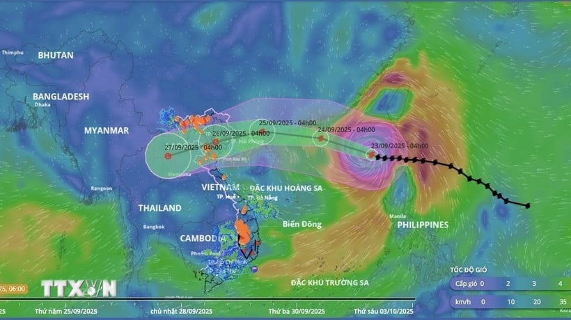 |
| Direction of storm number 9 at 4:00 a.m. on September 23. |
Due to the influence of the wide storm circulation, it is necessary to guard against the risk of thunderstorms, tornadoes and strong gusts of wind both before and during the storm's landfall.
The area near the center of the super typhoon is strong at level 17, gusting above level 17.
According to the National Center for Hydro-Meteorological Forecasting, at 4:00 a.m. on September 23, the center of the super typhoon was located at about 19.8 degrees North latitude; 118.8 degrees East longitude, in the northeastern sea area of the North East Sea. The strongest wind near the center of the super typhoon was level 17 (202-221 km/h), gusting above level 17. Moving in the West Northwest direction at a speed of about 20 km/h.
At 4:00 a.m. on September 24, the storm was in the northern sea area of the North East Sea, about 450km east of Leizhou Peninsula (China) with strong winds of level 16-17, gusting over level 17; moving in the West Northwest direction, traveling 20-25km per hour. The affected area is the northern sea area of the North East Sea. Disaster risk level 4.
At 4:00 a.m. on September 25, the storm was on the mainland south of Guangzhou province (China) with strong winds of level 12, gusts of level 15; moving west-northwest, 20-25km per hour and gradually weakening. The affected area is the northern sea area of the North East Sea with disaster risk level 4; the northern area of the Gulf of Tonkin with disaster risk level 3.
At 4:00 a.m. on September 26, the storm in the Northern region with strong winds of level 6, gusts of level 8; moving in the West-Southwest direction, traveling 20-25km per hour and weakening into a tropical depression. The affected area is the northwest sea area of the North East Sea, the Gulf of Tonkin area. Natural disaster risk level 3.
From the next 72 to 96 hours, the tropical depression moves in the West Southwest direction, about 20km per hour and weakens into a low pressure area.
Due to the impact of the storm, the northern sea area of the North East Sea has strong winds of level 8-9, then increasing to level 10-14, the area near the center of the super storm has winds of level 15-17, gusts above level 17, waves over 10m high; the sea is very rough.
From September 24, the eastern sea of Bac Bo Gulf (including Bach Long Vy island district) will have winds gradually increasing to level 6-7, gusting to level 9. From the evening and night of September 24, the Bac Bo Gulf area (including Bach Long Vy special zone, Van Don, Co To, Cat Hai and Hon Dau island) will have winds gradually increasing to level 8-9, waves 2-4m high, the area near the storm center will have winds of level 10-12, gusting to level 14, waves 4-6m high, and rough seas.
The coastal areas of Quang Ninh- Hai Phong provinces have storm surges of 0.5-1m. There is a high risk of landslides, sea dykes, and destruction of aquaculture areas and ships anchored along the coast due to strong winds, rising sea levels, and large waves.
On land, from early morning on September 25, coastal areas from Quang Ninh to Thanh Hoa will have winds gradually increasing to level 6-7, then increasing to level 8, areas near the storm center will have winds of level 9-10, gusting to level 12; areas deep inland in the Northeast will have strong winds of level 6-7, gusting to level 8-9.
From the night of September 24 to September 26, the Northern region, Thanh Hoa and Nghe An will have heavy to very heavy rain with common rainfall of 100-250mm, locally over 400mm. Beware of heavy rain causing urban flooding.
Heavy rains can cause flooding in low-lying areas; flash floods in small rivers and streams, and landslides on steep slopes.
Warning of heavy rain over 70mm in 3 hours in many areas
The National Center for Hydro-Meteorological Forecasting said that on the morning and night of September 23, the mountainous areas of the North and Thanh Hoa will have scattered showers and thunderstorms with rainfall of 10-30mm, with some places having heavy rain of over 70mm.
During the day and night of September 23, the Central Highlands will have scattered showers and thunderstorms with rainfall of 20-40mm, with some places experiencing heavy to very heavy rain of over 100mm.
In the afternoon and evening of September 23, the South Central Coast and Southern regions will have scattered showers and thunderstorms with rainfall of 15-30mm, with some places experiencing heavy rain of over 80mm.
Warning of risk of heavy rain over 70mm in 3 hours.
"Thunderstorms are likely to cause tornadoes, lightning, hail and strong gusts of wind. Localized heavy rains can cause flash floods on small rivers and streams, landslides on steep slopes and flooding in low-lying areas," noted Deputy Head of the Weather Forecasting Department Nguyen Huu Thanh.
On the night of September 22 and early morning of September 23, the mountainous areas of the North and Thanh Hoa, the Central Highlands and the South had scattered showers and thunderstorms, with some places experiencing heavy to very heavy rain. The rainfall from 7:00 p.m. on September 22 to 3:00 a.m. on September 23 was over 90mm in some places, such as: Xa De Phin station (Lai Chau) 114.2mm, Lung Vai station (Lao Cai) 96.6mm, Hien Chung station (Thanh Hoa) 127mm, Thon 9-Ia Toi station (Quang Ngai) 98.4mm, Krong Na station (Dak Lak) 94.6mm,...
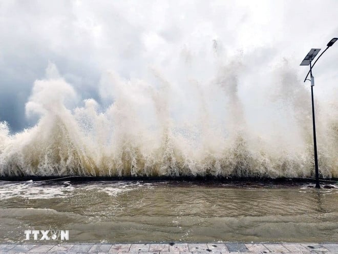
Many sea areas have strong winds and high waves.
According to information from the National Center for Hydro-Meteorological Forecasting, in Phu Quy special zone, there are strong southwest winds of level 5, sometimes level 6, gusting to level 7; Huyen Tran station has strong gusts of level 8.
 |
| Ready to respond to storms in the East Sea. (Illustration photo: VNA) |
Forecast, day and night of September 23, in the South of the North East Sea area (including Hoang Sa special zone), strong winds of level 7, sometimes level 8, gusts of level 9-10, rough seas, waves 3-5m high.
The central East Sea area has strong winds of level 6-7, gusts of level 9, rough seas, waves 3-5m high.
From Dak Lak to Ho Chi Minh City and the South China Sea area (including Truong Sa special zone), strong winds of level 6, sometimes level 7, gusts of level 8-9, rough seas, waves 3-5m high.
In addition, during the day and night of September 23, there will be storms in the North East Sea. The central East Sea, the Gulf of Tonkin, and the sea area from South Quang Tri to Khanh Hoa will have scattered showers and thunderstorms. During thunderstorms, there is a possibility of tornadoes, strong gusts of wind of level 6-7, and waves over 2 meters high.
Warning, day and night 9/24: Southern sea area of the North East Sea (including Hoang Sa special zone), central East Sea area, strong Southwest to South wind level 6-7, sometimes level 8, gusting level 9-10; waves 3-5m high, rough sea.
The sea area from Dak Lak to Ho Chi Minh City and the South East Sea area (including Truong Sa special zone) has strong southwest wind level 6, sometimes level 7, gusting to level 9; waves 3-5m high, rough seas.
From September 24, the eastern sea of Bac Bo Gulf (including Bach Long Vy island district) will have winds gradually increasing to level 6-7, gusting to level 9. From the evening and night of September 24, the Bac Bo Gulf area (including Bach Long Vy special zone, Van Don, Co To, Cat Hai and Hon Dau island) will have winds gradually increasing to level 8-9, the area near the storm center will have winds of level 10-12, gusting to level 14-15, waves 4-6m high, and rough seas.
Level of disaster risk due to strong winds at sea: level 2; especially coastal areas from Dak Lak to Ho Chi Minh City: level 3.
All vessels operating in the above areas are at high risk of being affected by cyclones, strong winds and large waves.
Source: VNA/Vietnam+
Source: https://baodongnai.com.vn/tin-moi/202509/anh-huong-bao-so-9-bac-bien-dong-gio-van-duy-tri-cap-sieu-bao-bien-dong-du-doi-4f0029d/

![[Photo] The 1st Congress of Party Delegates of Central Party Agencies, term 2025-2030, held a preparatory session.](https://vphoto.vietnam.vn/thumb/1200x675/vietnam/resource/IMAGE/2025/9/23/e3a8d2fea79943178d836016d81b4981)


![[Photo] General Secretary To Lam meets voters in Hanoi city](https://vphoto.vietnam.vn/thumb/1200x675/vietnam/resource/IMAGE/2025/9/23/d3d496df306d42528b1efa01c19b9c1f)
![[Photo] Prime Minister Pham Minh Chinh chairs the 14th meeting of the Steering Committee on IUU](https://vphoto.vietnam.vn/thumb/1200x675/vietnam/resource/IMAGE/2025/9/23/a5244e94b6dd49b3b52bbb92201c6986)


Comment (0)