
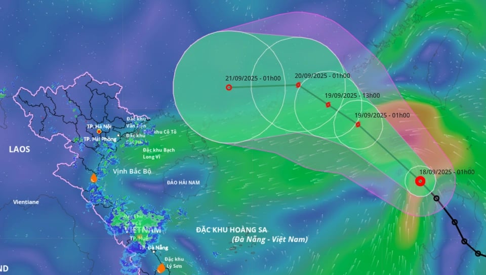
According to the National Center for Hydro-Meteorological Forecasting, due to the influence of the tropical depression that will strengthen into storm No. 8, today the northeastern sea area of the northern East Sea: strong winds level 6 - 7, gusts level 9. The area near the storm center will have strong winds level 8, gusts level 10. Waves 2.5 - 4.5 m high; rough seas.
The sea area from Khanh Hoa to Ho Chi Minh City, the area between the East Sea and the southwest of the East Sea (including the west of Truong Sa special zone) has southwest winds of level 5 - 6, gusting to level 7 - 8. Waves are 1.5 - 3 m high. During the day and tonight, the sea area northeast of the northern East Sea will begin to have storms.
The National Center for Hydro-Meteorological Forecasting said that due to the influence of the tropical depression circulation that will strengthen into storm No. 8, heavy rain will occur in the central coast (from Nghe An to Hue City) and some places in the North.
Weather forecast for the day and night of September 18, the Northern coastal region, from Thanh Hoa to Quang Tri, will have rainfall of 10 - 30 mm, some places will have heavy rain over 70 mm, with a risk of heavy rain over 70 mm/3 hours causing localized flooding.
The area from Hue City to Lam Dong and the South has rain, moderate rain and scattered thunderstorms with rainfall of 20 - 40 mm, in some places heavy to very heavy rain over 100 mm.
Localized heavy rain in the above areas is likely to cause flash floods on small rivers and streams, landslides on steep slopes and inundation in low-lying areas.
Source: https://quangngaitv.vn/ap-thap-nhiet-doi-da-di-vao-bien-dong-va-du-bao-trong-hom-nay-18-9-se-manh-len-thanh-bao-so-8-gay-mua-lon-tren-nhieu-vung-bien-dat-lien-mien-trung-6507465.html
![[Photo] Prime Minister Pham Minh Chinh chairs a meeting of the Government Standing Committee on overcoming the consequences of natural disasters after storm No. 11](https://vphoto.vietnam.vn/thumb/1200x675/vietnam/resource/IMAGE/2025/10/09/1759997894015_dsc-0591-jpg.webp)

![[Photo] President Luong Cuong attends the 80th Anniversary of the Traditional Day of Vietnamese Lawyers](https://vphoto.vietnam.vn/thumb/1200x675/vietnam/resource/IMAGE/2025/10/09/1760026998213_ndo_br_1-jpg.webp)

![[Photo] General Secretary To Lam visits Kieng Sang Kindergarten and the classroom named after Uncle Ho](https://vphoto.vietnam.vn/thumb/1200x675/vietnam/resource/IMAGE/2025/10/09/1760023999336_vna-potal-tong-bi-thu-to-lam-tham-truong-mau-giao-kieng-sang-va-lop-hoc-mang-ten-bac-ho-8328675-277-jpg.webp)


Comment (0)