

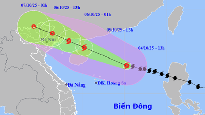
Forecast of location and direction of tropical depression at 1:00 p.m. this afternoon (Photo: NCHMF)
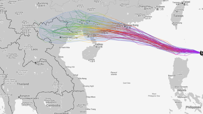
On the afternoon of September 16, the National Center for Hydro-Meteorological Forecasting said that this afternoon, the low pressure area in the sea east of Luzon Island (Philippines) has strengthened into a tropical depression.
At 1 p.m. this afternoon, the center of the tropical depression was located in the sea east of Luzon Island (Philippines). The strongest wind near the center of the tropical depression was level 6-7 (39-61 km/h), gusting to level 9.
It is forecasted that in the next 24 hours, the tropical depression will move northwest at a speed of about 15km/h and is likely to strengthen into a storm.
By 1:00 p.m. tomorrow, the storm center will be in the sea northeast of Luzon Island, with storm intensity at level 8, gusting to level 10.
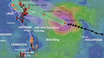
In the next 24 to 48 hours, the storm will move west-northwest at a speed of 15-20km/h and is likely to enter the East Sea. If it enters the East Sea, it will be the 8th storm this year.
At 1:00 p.m. on September 18, the storm center was in the northeastern sea area of the northern East Sea, the storm intensity remained strong at level 8, gusting to level 10.
From the next 48 to 72 hours, the storm will move mainly in the west-northwest direction, about 15km per hour, with little change in intensity.
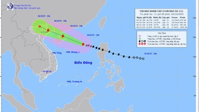
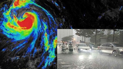
Due to the influence of a tropical depression, which may later become a storm, in the northeastern sea area of the northern East Sea, winds will gradually increase to level 6, gusting to level 8, near the storm center, winds will increase to level 7-8, gusting to level 10, and waves will be 2.5-4.5m high.
Ships operating in the above-mentioned dangerous areas are likely to be affected by storms, whirlwinds, strong winds and big waves./.
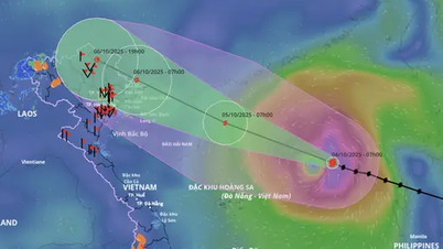
New low pressure area appears, likely to become tropical depression There is currently a low pressure area in the middle of the East Sea. The meteorological agency predicts that this low pressure area has the potential to strengthen into a tropical depression with a probability of 60-70%. The probability of this low pressure area strengthening into a storm is not high (under 10%). This low pressure area mainly causes thunderstorms, strong winds of level 5-6 in the central East Sea, and rough seas. According to the National Center for Hydro-Meteorological Forecasting, in the last 10 days of September, in the sea east of the Philippines, there is a high possibility of 1-2 strong storms forming and possibly entering the East Sea, affecting our mainland. |
According to Tuoi Tre Newspaper
Source: https://tuoitre.vn/ap-thap-nhiet-doi-ngoai-khoi-philippines-co-the-manh-len-thanh-bao-va-vao-bien-dong-20250916163537744.htm
Source: https://baolongan.vn/ap-thap-nhiet-doi-ngoai-khoi-philippines-co-the-manh-len-thanh-bao-va-vao-bien-dong-a202611.html

![[Photo] Bustling Mid-Autumn Festival at the Museum of Ethnology](https://vphoto.vietnam.vn/thumb/1200x675/vietnam/resource/IMAGE/2025/10/4/da8d5927734d4ca58e3eced14bc435a3)

![[Photo] General Secretary To Lam attends the 8th Congress of the Central Public Security Party Committee](https://vphoto.vietnam.vn/thumb/1200x675/vietnam/resource/IMAGE/2025/10/4/79fadf490f674dc483794f2d955f6045)

![[Photo] Solemn opening of the 8th Congress of the Central Public Security Party Committee, term 2025-2030](https://vphoto.vietnam.vn/thumb/1200x675/vietnam/resource/IMAGE/2025/10/4/f3b00fb779f44979809441a4dac5c7df)


![[VIDEO] Summary of Petrovietnam's 50th Anniversary Ceremony](https://vphoto.vietnam.vn/thumb/402x226/vietnam/resource/IMAGE/2025/10/4/abe133bdb8114793a16d4fe3e5bd0f12)
![[VIDEO] GENERAL SECRETARY TO LAM AWARDS PETROVIETNAM 8 GOLDEN WORDS: "PIONEER - EXCELLENT - SUSTAINABLE - GLOBAL"](https://vphoto.vietnam.vn/thumb/402x226/vietnam/resource/IMAGE/2025/7/23/c2fdb48863e846cfa9fb8e6ea9cf44e7)


Comment (0)