
According to the National Center for Hydro-Meteorological Forecasting, at 1:00 p.m. on October 17, the center of the storm Tropical depression in the sea east of central Philippines. The strongest wind near the center of the tropical depression is level 7 (50-61km/h), gusting to level 9, moving west at a speed of 20-25km/h.
At around 1:00 p.m. on October 18, a tropical depression in the sea east of the central Philippines, moving west at 20-25km per hour, is likely to strengthen into a storm with a strong intensity of level 8, gusting to level 10.
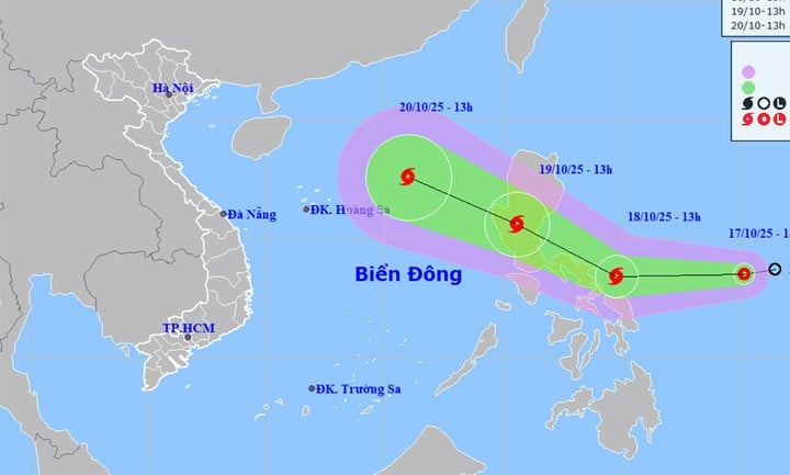
At 1 p.m. on October 19, the center of the storm was located on Luzon Island (Philippines), changing direction to West Northwest, speed about 20-25 km/h. The strongest wind near the center of the storm was level 8, gusting to level 10.
From the next 48 to 72 hours, the storm will move mainly in the West-Northwest direction, traveling 20-25km per hour, entering the East Sea, becoming a typhoon. storm number 12 in 2025, may be stronger.
According to the assessment of the Department of Hydrometeorology on the afternoon of October 16, when the storm moves into the East Sea, there will be cold air moving down from the North, so the storm may weaken at sea.
Accordingly, from the night of October 18, the North will begin to be affected by cold air, which will then strengthen during October 20-25. The weather will be cold at night and in the morning, and mountainous areas may become cold.
The impact of the tropical depression later intensified into a storm. From October 19, the sea area east of the North East Sea gradually increased to level 6-7, near the center of the storm, the wind was level 8, gusting to level 10, waves 2.5-4.5m high. The sea was rough.
Around October 20-22, the North East Sea area (including Hoang Sa special zone) is likely to be affected by strong winds of level 9-11, gusting to level 14.
In addition, the meteorological agency said that in the past 2 hours (from 11am to 1pm on October 17), Ha Tinh had moderate to heavy rain, with rainfall in Kim Son Lake reaching 77.2mm, Ky Lam reaching 48.6mm... The soil moisture model shows that some areas in Ha Tinh province are nearly saturated (over 85%) or have reached a saturated state.
In the next 3-6 hours, this area will continue to have rain with common accumulated rainfall of 20-50mm, some places over 90mm. There is a risk of flash floods on small rivers and streams, landslides on steep slopes, especially in the following communes/wards: Ky Lac, Cam Due, Cam Hung, Huong Do, Huong Son, Huong Xuan, Kim Hoa, Ky Hoa, Ky Thuong, Ky Van, Song Tri ward, Phuc Trach, Son Hong.
Source: https://baolangson.vn/ap-thap-nhiet-doi-sap-manh-thanh-bao-vao-bien-dong-khi-khong-khi-lanh-tran-ve-5062232.html


![[Photo] Closing ceremony of the 18th Congress of Hanoi Party Committee](https://vphoto.vietnam.vn/thumb/1200x675/vietnam/resource/IMAGE/2025/10/17/1760704850107_ndo_br_1-jpg.webp)


![[Photo] Nhan Dan Newspaper launches “Fatherland in the Heart: The Concert Film”](https://vphoto.vietnam.vn/thumb/1200x675/vietnam/resource/IMAGE/2025/10/16/1760622132545_thiet-ke-chua-co-ten-36-png.webp)


Comment (0)