
 |
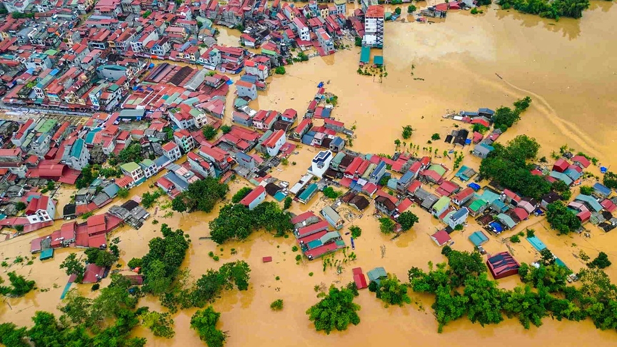
| Direction of the tropical depression. Photo: Center for Hydro-meteorological Forecasting |
That is what Mr. Nguyen Van Huong, Head of Weather Forecast Department, National Center for Hydro-Meteorological Forecasting, shared with reporters about the development of the tropical depression on the evening of September 17.
Mr. Nguyen Van Huong said that a tropical depression is currently active in the East Sea. By 5 p.m. on September 18, the tropical depression will move to the east of the Hoang Sa area and is likely to strengthen into a storm.
After strengthening into a storm, the storm will move in the West Northwest direction. With such a direction of movement, the circulation of the tropical depression will cause strong winds of level 6-7 in the North East Sea and the sea area of Hoang Sa, the area near the storm center will be strong at level 8. The area from Quang Binh to Quang Ngai in the next 24-48 hours will have gradually stronger winds.
According to Mr. Nguyen Van Huong, up to this point, there are likely to be two scenarios for storm number 4 .
Scenario 1: There is a high possibility that the storm will move to the area from Thanh Hoa to Quang Ngai (the highest probability is about 70%). In this scenario, the sea area directly affected by the storm is the sea area from Thanh Hoa to Quang Ngai. It is forecasted that in the next 24-48 hours, the sea area from Quang Binh to Quang Ngai will have strong winds.
Along with that, on September 18, the central coastal region will have widespread rain. By noon and afternoon of September 18, the North Central and Central Central regions will have widespread rain. From the evening and night of September 18 to September 21, the above area is likely to have a widespread moderate to heavy rain.
In addition, under the impact of the tropical low pressure circulation that later strengthens into storm No. 4, the North East Sea and Hoang Sa areas will be directly affected by the low pressure circulation, followed by the sea area from Thanh Hoa to Thua Thien Hue, the sea area of Da Nang, Quang Nam, and Quang Ngai.
 |
| Mr. Nguyen Van Huong, Head of Weather Forecasting Department, shared about the tropical depression situation on the evening of September 17. Photo: BL |
Second scenario: The storm is likely to move into the northern part of the Gulf of Tonkin or move down to the southern part of the Central region (this scenario has a low probability of about 15%).
Mr. Nguyen Van Huong recommends that ship owners and captains in the areas analyzed above (especially Thua Thien Hue province) should pay close attention to finding shelter or anchoring their boats in safe locations.
Authorities and people in the above areas should pay attention to dike safety, especially for dike projects under construction, and flooding in low-lying coastal areas.
On land, people need to be on guard against convective thunderstorms before tropical depressions and storms hit. When this type of weather occurs, the consequences will be the collapse of trees, the possibility of metal roofs and advertising signs being blown away.
Regarding heavy rain, people in mountainous areas, midlands of North Central and Central Central regions need to be on guard against the possibility of flooding in urban areas and from the night of September 18 to September 21, there is a possibility of flash floods and landslides in the above areas. "This lesson has recently happened in the North, so people in affected areas need to be extremely vigilant," Mr. Nguyen Van Huong noted./.


![[Photo] Prime Minister Pham Minh Chinh chairs the 16th meeting of the National Steering Committee on combating illegal fishing.](https://vphoto.vietnam.vn/thumb/1200x675/vietnam/resource/IMAGE/2025/10/07/1759848378556_dsc-9253-jpg.webp)


![[Photo] Super harvest moon shines brightly on Mid-Autumn Festival night around the world](https://vphoto.vietnam.vn/thumb/1200x675/vietnam/resource/IMAGE/2025/10/07/1759816565798_1759814567021-jpg.webp)


Comment (0)