
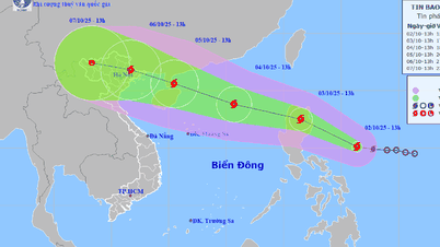
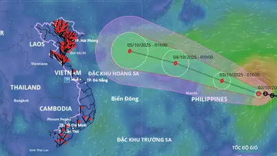
According to the National Center for Hydro-Meteorological Forecasting, at 1 p.m. on October 2, the center of storm Matmo was at about 15.1 degrees north latitude and 126.4 degrees east longitude, in the sea east of the Philippines. At the center of the storm, the strongest wind was at level 8, equivalent to a speed of 62 - 74 km/h, gusting to level 10.
 moves very fast, the North is directly affected")
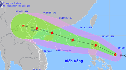
Storm Matmo (storm No. 11) is forecast to directly affect the northern provinces around October 6. PHOTO: VNDMS
At this location, the center of storm Matmo is about 650 km from the East Sea. Currently, the storm is moving west-northwest, at a very fast speed of about 25 km/hour. It is forecasted that in the evening and night of tomorrow, October 3, storm Matmo will enter the East Sea, becoming storm number 11 in 2025. When entering the East Sea, storm Matmo is forecasted to continue to strengthen to level 12, gusting to level 15.
The National Center for Hydro-Meteorological Forecasting warns that due to the influence of storm Matmo's circulation, from noon and afternoon on October 3, the sea area east of the northern East Sea will have winds gradually increasing to level 6 - 7; then increasing to level 8 - 9. The area near the storm's center will have strong winds of level 10 - 11, gusting to level 12, with waves 4 - 6 m high. The sea will be very rough.
It is forecasted that when storm Matmo enters the East Sea, between October 4 and 5, the northern East Sea area will likely be affected by strong winds of level 11-12, gusting to level 15. Accordingly, all ships operating in the above-mentioned dangerous areas are likely to be affected by storms, strong winds, and large waves.
Storm Matmo is likely to directly affect the North.
According to the National Center for Hydro-Meteorological Forecasting, it is likely that storm Matmo (storm No. 11) will directly affect the northern provinces around October 6.
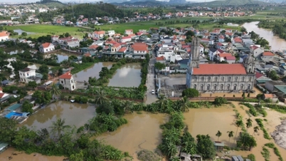
Due to the influence of storm circulation, the Northern and North Central regions from the night of October 5 to 7 are likely to experience widespread heavy rain.
The name Matmo was proposed by the US hurricane forecasting agency, and is part of the list of storm names managed by the Hurricane Committee of the World Meteorological Organization (WMO).
The name of storm Matmo means "heavy rain". In fact, in 2019, the south central provinces suffered a lot of damage in a storm also internationally named storm Matmo, the 5th storm in 2019, affecting the coastal provinces of Quang Ngai, Binh Dinh, and Phu Yen .
The 2019 storm Matmo caused widespread heavy rain from Thua Thien - Hue to Ninh Thuan and the Central Highlands on October 30 - 31, with rainfall ranging from 300 - 400 mm/period. In particular, the provinces of Binh Dinh, Phu Yen, and Khanh Hoa had rainfall of 400 - 600 mm/period, causing flooding in many places./.
According to Thanh Nien Newspaper
Source: https://thanhnien.vn/bao-matmo-bao-so-11-di-rat-nhanh-mien-bac-chiu-anh-huong-truc-tiep-185251002183034709.htm
Source: https://baolongan.vn/bao-matmo-bao-so-11-di-rat-nhanh-mien-bac-chiu-anh-huong-truc-tiep-a203634.html

![[Photo] Binh Trieu 1 Bridge has been completed, raised by 1.1m, and will open to traffic at the end of November.](https://vphoto.vietnam.vn/thumb/1200x675/vietnam/resource/IMAGE/2025/10/2/a6549e2a3b5848a1ba76a1ded6141fae)


Comment (0)