
 |
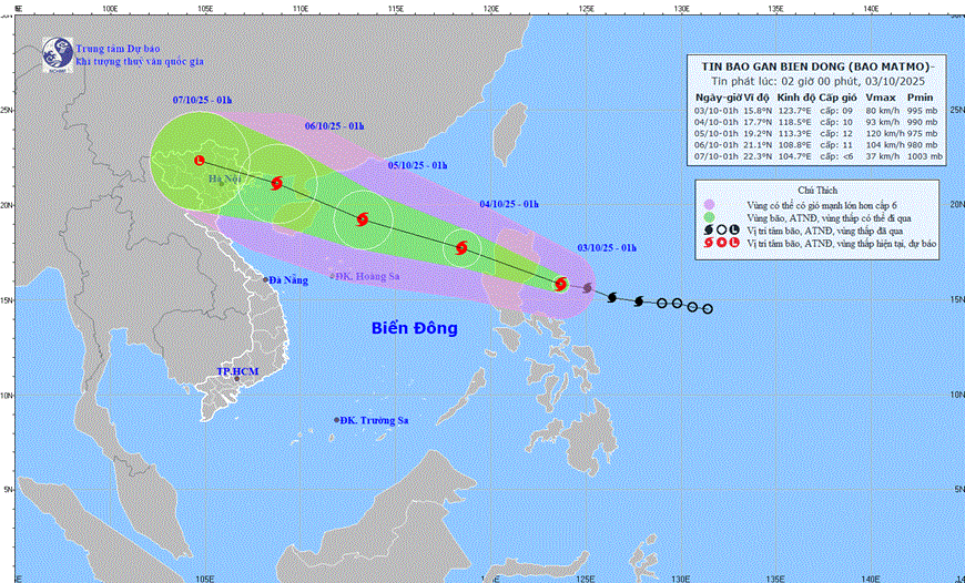
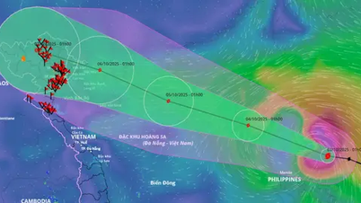
| The path of storm MATMO. Photo: nchmf.gov.vn |
Forecast, from noon on October 3, the eastern sea area of the North East Sea will gradually increase to level 6-7, then increase to level 8-9, near the storm center will be level 10-11, gusting to level 13; waves 4-6m high; rough seas.
In addition, from noon on October 3, the sea area east of the North East Sea will have storms. The sea area east of the Central East Sea, from Ca Mau to An Giang and the Gulf of Thailand will have scattered showers and thunderstorms; during thunderstorms, there is a possibility of tornadoes, strong gusts of wind of level 6-7 and waves over 2.0m high.
Day and night 4-10 strong winds, rough seas. Northern sea area of the North East Sea strong winds level 8-10, near the storm center level 11-12, gusts level 15; waves 5-7m high; rough seas. Southern sea area of the North East Sea area (including Hoang Sa special zone): Strong winds level 6-7, gusts level 9; waves 3-5m high; rough seas.
The National Center for Hydro-Meteorological Forecasting warns that all vessels operating in the above areas are at high risk of being affected by strong winds and large waves. The sea area east of the North East Sea has a level 3 risk of natural disasters at sea.
Source: https://baothainguyen.vn/xa-hoi/202510/bao-matmo-o-phia-dong-dao-luzon-philippines-va-di-chuyen-theo-huong-tay-tay-bac-96a2f54/
![[Photo] Prime Minister Pham Minh Chinh chairs meeting to deploy overcoming consequences of storm No. 10](https://vphoto.vietnam.vn/thumb/1200x675/vietnam/resource/IMAGE/2025/10/3/544f420dcc844463898fcbef46247d16)


![[Photo] Students of Binh Minh Primary School enjoy the full moon festival, receiving the joys of childhood](https://vphoto.vietnam.vn/thumb/1200x675/vietnam/resource/IMAGE/2025/10/3/8cf8abef22fe4471be400a818912cb85)


Comment (0)