

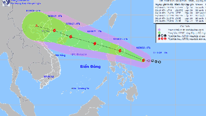
At 6:00 a.m. on September 23, the center of the storm was located at about 19.8 degrees North latitude; 118.5 degrees East longitude.
The National Center for Hydro-Meteorological Forecasting said that at 6:00 a.m. on September 23, the center of the storm was located at about 19.8 degrees North latitude; 118.5 degrees East longitude, about 840 km east of Leizhou Peninsula (China). The strongest wind speed: Level 17 (202-221 km/h), gusting above level 17. Forecast: in the next 3 hours, the storm will move west-northwest at a speed of about 20 km/h.
In the next 24 hours, the super storm shows no signs of weakening, moving faster in the west-northwest direction at a speed of about 25 km/hour.
At 4:00 a.m. on September 24, super typhoon RAGASA (storm No. 9) was located at 21.1 degrees North latitude; 114.5 degrees East longitude; in the northern sea area of the North East Sea, about 450 km east of Leizhou Peninsula (China). The super typhoon is at level 16-17, gusting above level 17, continuing to move west-northwest.
In the following hours, super typhoon RAGASA continued to maintain its speed and intensity and made landfall in mainland China before weakening.
At around 4am on September 25, storm RAGASA will be at around 21.5 degrees North latitude; 109.6 degrees East longitude; on the mainland south of Guangzhou province (China).
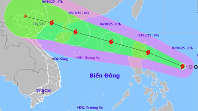
After making landfall in China, storm RAGASA weakened rapidly and entered the Gulf of Tonkin before making landfall in Vietnam and weakening into a tropical depression. At around 4:00 a.m. on September 26, the tropical depression was at around 20.8 degrees north latitude; 105.1 degrees east longitude; in the northern region. The tropical depression was at level 6, gusting to level 8, moving west-southwest and continuing to move deeper into the mainland.
Over the next 72-96 hours, the tropical depression will move west-southwest at about 20 km per hour and weaken into a low pressure area.
However, despite weakening, the storm's circulation is still very wide and dangerous, possibly causing strong winds, big waves and heavy rain for the Northern and North Central provinces, especially from September 25 and 26.
With the current forecast scenario of the storm moving, the storm's impact area is from Quang Ninh - Ha Tinh . The strongest storm wind area is from Quang Ninh - Thanh Hoa (coastal wind level 7-9, gusts 10-12, storm center level 9-11, gusts 14, deeper inland 6-7, gusts 9-10). The period of strong winds from the morning of September 25th lasts until the night of September 25th.
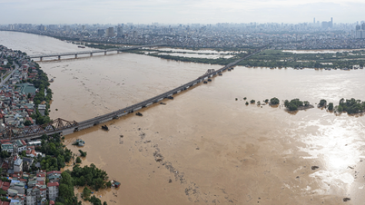
Heavy rain will be concentrated in the North, Thanh Hoa - Ha Tinh with rainfall of 70-150 mm. Rain will be concentrated in Thai Nguyen, South Tuyen Quang, Lao Cai , Phu Tho, the Northern Delta will have rain of 150-250 mm, locally over 450 mm.
East Sea waves over 10 m
Due to the influence of super typhoon RAGASA (typhoon No. 9), the northern sea area of the northern East Sea has strong winds of level 8-9, then increasing to level 10-14, the area near the center of the super typhoon has winds of level 15-17, gusts above level 17, waves over 10 m high; the sea is very rough.
From September 24, the eastern sea of the Gulf of Tonkin will have winds gradually increasing to level 6-7, gusting to level 9. From the evening and night of September 24, the Gulf of Tonkin area (including Bach Long Vy, Van Don, Co To, Cat Hai and Hon Dau islands) will have winds gradually increasing to level 8-9, waves 2-4 m high, the area near the storm center will have winds of level 10-12, gusting to level 14, waves 4-6 m high; the sea will be very rough.
The coastal areas of Quang Ninh- Hai Phong provinces have storm surges of 0.5-1 m. There is a high risk of landslides, sea dykes, and destruction of aquaculture areas and ships anchored along the coast due to strong winds, rising sea levels, and large waves.
On land, from early morning of September 25, coastal areas from Quang Ninh to Thanh Hoa have winds gradually increasing to level 6-7, then increasing to level 8, areas near the storm center have winds of level 9-10, gusting to level 12; areas deep inland in the Northeast have strong winds of level 6-7, gusting to level 8-9.
Thu Cuc
Source: https://baochinhphu.vn/bao-ragasa-anh-huong-truc-tiep-dat-lien-viet-nam-vao-khoang-ngay-25-9-102250923073605259.htm


Comment (0)