
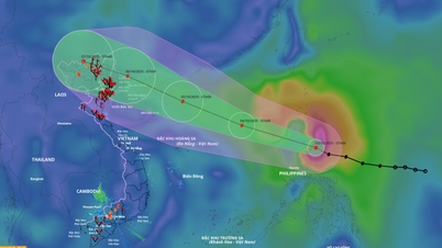
According to the National Center for Hydro-Meteorological Forecasting, on the afternoon of September 20, storm RAGASA is active in the East of Luzon Island (Philippines) with winds of level 12, gusts of level 15. The storm tends to continue to strengthen and move into the East Sea in the next few days.
At 1 p.m. on September 20, the center of storm RAGASA was at about 16.7 degrees North latitude; 129.1 degrees East longitude, about 730 km east of Luzon Island (Philippines). The strongest wind near the center of the storm: level 12 (118–133 km/h), gusting to level 15. Moving direction: West Northwest, speed 5–10 km/h.
 |
Forecast, at 1pm on September 21, the storm will move west-northwest at 10-15 km/h, with the possibility of strengthening. The center of the storm is at about 18.3 degrees North latitude; 126.7 degrees East longitude, about 490 km East-Northeast of Luzon Island. The storm intensity reaches level 13-14, gusting above level 17.
At 1 p.m. on September 22, the storm continued to move West Northwest at 15-20 km/h. The center of the storm was at about 19.7 degrees North latitude; 123.5 degrees East longitude, about 220 km North Northeast of Luzon Island. The intensity was level 15-16, gusting to level 17.
At 1 p.m. on September 23, the storm will move west-northwest at 20-25 km/h, likely entering the East Sea. The center of the storm will be at about 20.8 degrees North latitude; 118.2 degrees East longitude, in the northeastern sea area of the North East Sea. The intensity will remain at level 15-16, gusting to level 17.
Danger zone: North of latitude 17.0 degrees North; East of longitude 116.0 degrees East. Disaster risk level: level 4 (Northeast sea area of the East Sea).
During the next 72–120 hours, storm RAGASA moved mainly in a westerly direction, traveling about 20 km per hour, with a tendency to gradually weaken.
Impact forecast: At sea, from the afternoon of September 22: winds gradually increase to level 6-7, then increase to level 8-9, gusting to level 11. From the night of September 22: strong winds level 10-13, near the storm center level 14-16, gusting above level 17.
Vessels operating in the danger zone need to take special care, as they may be exposed to strong winds, large waves, thunderstorms and tornadoes.
According to PV/VOV.VN
Source: https://baovinhlong.com.vn/thoi-su/202509/bao-ragasa-manh-them-di-chuyen-theo-huong-tay-tay-bac-a1f277e/


![[Photo] Binh Trieu 1 Bridge has been completed, raised by 1.1m, and will open to traffic at the end of November.](https://vphoto.vietnam.vn/thumb/1200x675/vietnam/resource/IMAGE/2025/10/2/a6549e2a3b5848a1ba76a1ded6141fae)


Comment (0)