
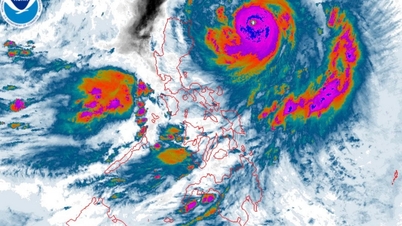
According to the National Center for Hydro-Meteorological Forecasting, at 1:00 a.m. on September 22, the center of super typhoon Ragasa was about 230km east-northeast of Luzon Island (Philippines).
The strongest wind near the storm center is level 16-17 (184-221km/h), gusting above level 17. The storm moves mainly in the West Northwest direction, at a speed of about 20km/h.
At 1am on September 23, super typhoon Ragasa was in the northeastern part of the East Sea. The strongest wind near the storm center was level 17, gusting above level 17.
Early the next morning, super typhoon Ragasa was in the northern part of the East Sea, about 490km east of Leizhou Peninsula (China). The storm intensity was now level 16-17, gusting above level 17.
At 1am on September 25, storm Ragasa was in the sea east of Leizhou Peninsula (China). The strongest wind near the storm center was level 14-15, gusting to level 17, with a tendency to weaken.
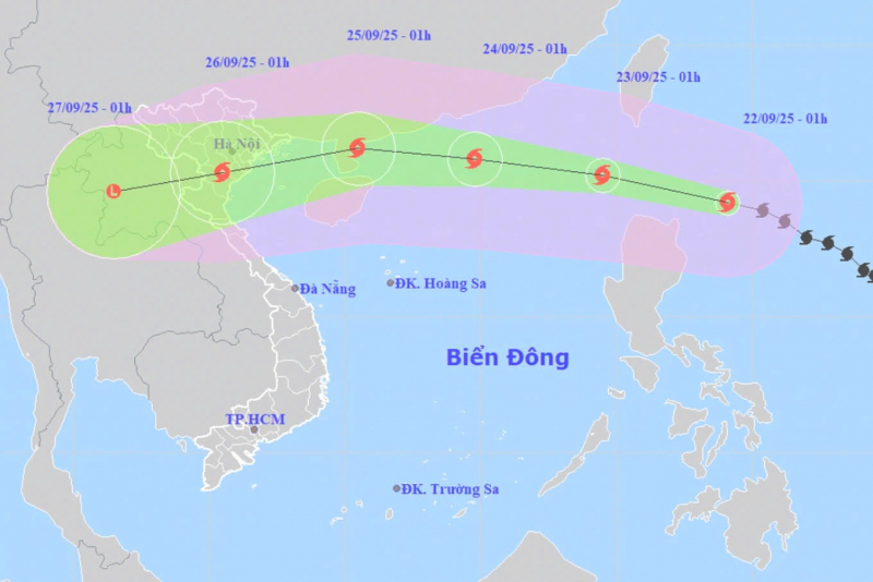
In the next 72-120 hours, super storm Ragasa will move in the West Southwest direction, about 20km per hour, and its intensity will continue to weaken.
The meteorological agency forecasts that due to the influence of super typhoon Ragasa, the northeastern sea of the East Sea will have winds gradually increasing to level 8-9, then increasing to level 10-14.
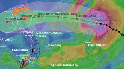
According to Dr. Hoang Phuc Lam, in the past 2-3 days, most models and storm forecasting centers of the world and Vietnam have simulated this as a storm with a very wide circulation, very strong intensity when operating in the East Sea, reaching super typhoon level, strongest between September 22-23.
In particular, the maximum intensity of storm No. 9 is forecasted by Japanese meteorological agencies to reach 195km/h (level 16), gusts over 17. The Chinese meteorological agency forecasts it to reach 223km/h (above level 17), gusts over 17. The Hong Kong (China) meteorological agency forecasts 240km/h (above level 17), gusts over 17.
By September 24, when moving to the sea area south of Guangdong province (China), due to the storm's northern circulation being affected by terrain friction, storm No. 9 is forecast to weaken and when entering the Gulf of Tonkin, the storm's intensity will decrease by 2-4 levels compared to when it was still offshore.
However, Mr. Lam emphasized, it is also necessary to note that a worse scenario is still possible. That is, when entering the East Sea, the storm will move mainly in a westerly direction, the lower the storm trajectory, the less the storm intensity will be reduced, the impact of strong winds and large waves in the Gulf of Tonkin will be higher.
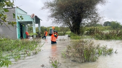
With this scenario, in the Northern coastal area, the Central coastal area from Thanh Hoa - Hue will have very strong storm winds, accompanied by heavy rain.
In addition, there is currently an additional cold air mass in the North moving towards our country. The interaction of cold air with storms in the coming days will make the trajectory and intensity of storm Ragasa more complicated and long-term forecasts (after 3 days) currently have a large dispersion.
Mr. Lam said that the two scenarios mentioned above only deviate from the North or South by 50-100km (only equal to the average error of the past 5 years in forecasting storm trajectories 12 hours in advance), but the intensity of the storm when approaching the coast of Vietnam will be very different, the consequences of the impact will also be different, therefore, it is necessary to continue updating the forecasts according to monitoring data and subsequent analysis.
Source: https://cand.com.vn/doi-song/bao-ragasa-vao-nuoc-ta-trong-tam-do-bo-tu-quang-ninh-den-ha-tinh-i782054/
![[Photo] Prime Minister Pham Minh Chinh chairs the first meeting of the Central Steering Committee on housing policy and real estate market](https://vphoto.vietnam.vn/thumb/1200x675/vietnam/resource/IMAGE/2025/9/22/c0f42b88c6284975b4bcfcf5b17656e7)


![[Photo] General Secretary To Lam attends the 1st Congress of the Central Party Committee of the Fatherland Front and Central Mass Organizations](https://vphoto.vietnam.vn/thumb/1200x675/vietnam/resource/IMAGE/2025/9/23/2aa63d072cab4105a113d4fc0c68a839)


Comment (0)