
On the afternoon of September 22, the Ministry of Agriculture and Environment held a meeting with representatives of relevant ministries and agencies on response to storm Ragasa, chaired by Deputy Minister of Agriculture and Environment Nguyen Hoang Hiep.
At the meeting, Mr. Mai Van Khiem, Director of the National Center for Hydro-Meteorological Forecasting, said: It is estimated that after 10 pm tonight (September 22), storm RAGASA will enter the East Sea. In the next 6 hours, the storm is likely to remain at the same level, and tomorrow it will remain at level 16 - 17.
The National Center for Hydro-Meteorological Forecasting assessed that super typhoon Ragasa in the East Sea has an intensity equivalent to the strongest intensity of typhoon No. 3 ( Yagi ) in 2024. However, when passing through the Leizhou Peninsula, China, super typhoon RAGASA is likely to weaken, when entering the Northern region, it is less likely to have a strong impact like typhoon Yagi.
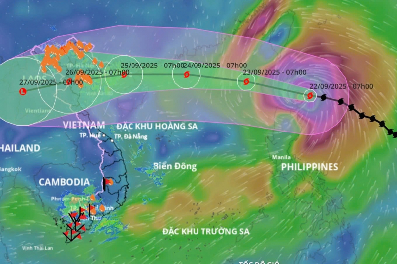
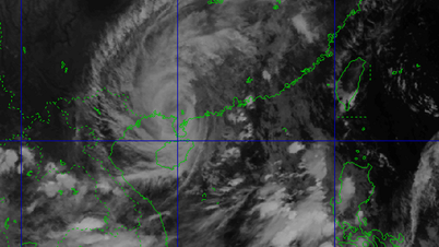
The movement of storm Ragasa (Photo: Vietnam Disaster Monitoring System).
In the sea area, the wind and waves are very strong, so attention should be paid to boat activities. In the sea area from Quang Ninh to Thanh Hoa province, the waves are forecast to be 2-4 meters high.
Mr. Pham Duc Luan, Director of the Department of Dyke Management and Natural Disaster Prevention and Control, emphasized that although the storm is forecast to weaken, localities should not be subjective and need to proactively respond. Up to now, the Prime Minister has issued a telegram directing localities, and the Ministry of Agriculture and Environment has sent documents to localities to warn about the storm.
The Director of the Department of Dyke Management and Natural Disaster Prevention and Control added that according to the rainfall forecast by the National Center for Hydro-Meteorological Forecasting, the initial assessment is that floods will occur on the river system. Small rivers and streams may reach alert level 2, alert level 3. Main rivers may reach alert level 1, alert level 2.
It is now the end of the rainy season so many lakes are full, especially hydroelectric and irrigation systems. It is necessary to ensure that irrigation and hydroelectric reservoirs are able to cope with localized heavy rains...
Responding to storm No. 9, Major General Pham Hai Chau, Deputy Director of the Department of Rescue and Relief (Ministry of National Defense) said that currently, units in the area expected to be affected by storm No. 9 have prepared plans and strategies. More than 300,000 militia and self-defense officers and soldiers, 8,000 vehicles and six aircraft are ready to respond when situations arise.
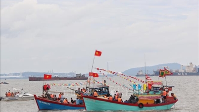
The Ministry of National Defense has directed the Border Guard Command at sea routes to call, notify, and transmit information about the storm's direction. Currently, more than 54,000 vehicles and more than 200,000 fishermen have been called, counted, and instructed to know the storm's direction to take safe shelter.
Major General Pham Hai Chau also emphasized that localities should not be subjective because storm No. 9 is considered very complicated. Major General Pham Hai Chau requested that localities and agencies be ready to review plans and plans, and re-examine key areas with high risk of incidents to have appropriate response measures. Pay special attention to the Quang Ninh area due to frequent impacts of storm circulation, and mountainous areas due to the risk of major landslides due to heavy rain.
The local Civil Defense Command strictly maintains the on-duty regime. Do a good job of propaganda so that people can grasp information about the 112 switchboard (operated by the Military Commands of the provinces from August 23) to urgently call in case of emergency, and coordinate timely response.
Directing at the meeting, Deputy Minister Nguyen Hoang Hiep emphasized the need to grasp the situation of storm No. 9, from which to propose comprehensive measures. Storm No. 9 is the strongest storm in 2025, the strongest in history we have measured in the East Sea, when it made landfall in the East Sea in the early morning of September 23. According to the forecast, the closer the storm gets to Vietnam, the weaker it will be. The storm will make landfall in Vietnam from September 25. When it makes landfall, it is forecast to be level 8 or level 9.
“However, this is a 72-hour forecast so the accuracy is not high, localities should not be subjective. It is necessary to strictly control boats, depending on the situation, ban the sea, and strictly control cages. Currently, according to the operating process, many reservoirs are full of water, it is necessary to calculate rain scenarios to have appropriate response plans.
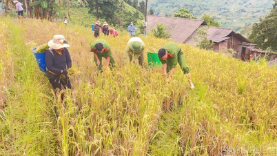
The consequences of storms and extreme weather patterns of Ragasa are very dangerous. Up to this point, the North still has more than 600,000 hectares of rice and many crops that have not been harvested, the storm has caused quite a lot of damage. It is necessary to calculate and have solutions soon, consider which areas can be harvested and harvest early," Mr. Hiep directed.
Along with that, the National Center for Hydro-Meteorological Forecasting needs to ensure information on storm developments every 3 hours. Press agencies need to step up propaganda about the 112 switchboard, the national emergency number set up to provide a communication channel for requesting assistance and search and rescue nationwide...
Source: https://cand.com.vn/doi-song/khong-chu-quan-vi-hinh-thai-thoi-tiet-cuc-doan-nguy-hiem-cua-bao-ragasa--i782145/


![[Photo] Closing of the 1st Congress of Party Delegates of Central Party Agencies](https://vphoto.vietnam.vn/thumb/1200x675/vietnam/resource/IMAGE/2025/9/24/b419f67738854f85bad6dbefa40f3040)


![[Photo] Editor-in-Chief of Nhan Dan Newspaper Le Quoc Minh received the working delegation of Pasaxon Newspaper](https://vphoto.vietnam.vn/thumb/1200x675/vietnam/resource/IMAGE/2025/9/23/da79369d8d2849318c3fe8e792f4ce16)


![[Photo] Solemn opening of the 1st Congress of Party Delegates of Central Party Agencies](https://vphoto.vietnam.vn/thumb/402x226/vietnam/resource/IMAGE/2025/9/24/82a89e250d4d43cbb6fcb312f21c5dd4)


Comment (0)