
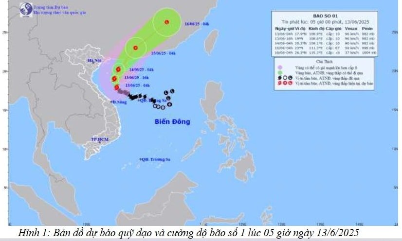
The strongest wind near the storm center is level 10 (89 - 102 km/h), gusting to level 13; moving northwest at a speed of about 10 km/h.
In the West of the North East Sea (including the waters of Hoang Sa archipelago), the offshore waters from Quang Tri to Quang Ngai have strong winds of level 6 - 8, near the storm's eye level 9 - 10, gusts of level 13, waves 3.0 - 5.0 m high, near the storm's eye 4.0 - 6.0 m, very rough seas.
From June 13, the Gulf of Tonkin will have winds gradually increasing to level 6-7, near the storm center to level 8-9, gusting to level 11, waves 2.0-4.0 m high, very rough seas.
From June 13, the sea areas of Quang Ninh, Hai Phong , Thai Binh, Nam Dinh, Ninh Binh and Thanh Hoa will have winds gradually increasing to level 5, then increasing to level 6, gusting to level 7 - 8, waves 1.5 - 2.5 m high, rough seas. Risk level of strong wind disaster at sea: Level 2.
From the morning of June 13, there will be heavy thunderstorms in the Gulf of Tonkin and the sea area from Quang Ninh to Thanh Hoa. During the thunderstorms, there is a possibility of tornadoes and strong gusts of wind of level 8-9.
Due to the impact of the storm on June 13, Hai Duong province will have scattered showers and thunderstorms, locally moderate rain, with rainfall ranging from 10 - 30 mm, and more in some places.
PVSource: https://baohaiduong.vn/bao-so-1-giat-cap-13-tren-vung-bien-cua-dao-hai-nam-trung-quoc-hai-duong-co-mua-rao-rai-rac-413949.html


Comment (0)