
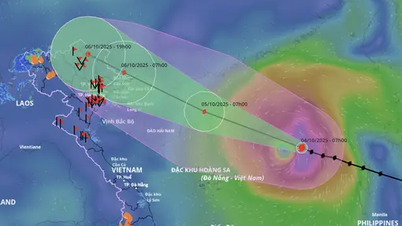
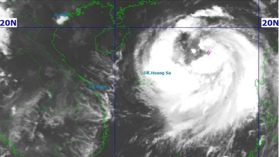
According to the National Center for Hydro-Meteorological Forecasting, at 6:00 a.m. this morning, October 5, the center of storm No. 11 was at about 18 degrees North latitude - 117.1 degrees East longitude, about 530km East Northeast of the Hoang Sa archipelago (special zone).
Storm level 11 (103-117km/h), gust level 14. In the next 3 hours, the storm will move in the West Northwest direction at a speed of 20-25km/h.

It is forecasted that early tomorrow morning, October 5, the storm will be about 130km east of Leizhou Peninsula (China). At this time, the storm is likely to strengthen to level 13, gusting to level 16. The entire North East Sea area is in the danger zone. By dawn on October 6, the storm will enter the northeastern sea area of the Gulf of Tonkin, then head straight for the coast of Quang Ninh province with the intensity decreasing to level 10, gusting to level 13. By the afternoon of October 6, the storm will move deep into the mainland of the Northeast region.
Vietnam's meteorological agency warned that the coastal areas of Quang Ninh - Hai Phong are likely to be flooded by storm surges combined with high tides in low-lying coastal areas and river mouths. On land from Quang Ninh to Ninh Binh, winds will gradually increase to level 6-8, near the storm's eye to level 9-10, which can cause trees to fall, roofs to be blown off, houses and electric poles to be damaged. Inland in the Northeast region, winds will be strong at level 6-7, gusting to 8-9.
")
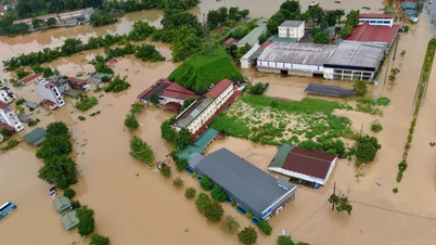
The storm also caused widespread heavy rain. From the night of October 5 to the end of October 7, the North, Thanh Hoa and Nghe An will have heavy to very heavy rain with common rainfall of 100-200mm, some places over 300mm. The mountainous and midland areas of the North will have common rainfall of 150-250mm, some places over 400mm, warning of the risk of flash floods and landslides.
According to some meteorological experts, storm No. 11 has many similarities with storm No. 9. Before making landfall in the northern region of the Gulf of Tonkin, storm No. 9 was a super storm (level 16-17), but when it made landfall in Vietnam (the northern mountainous region), the storm was not as strong as forecast and did not cause heavy rain as previously forecast by the Vietnam Meteorological Agency.
Source: https://www.sggp.org.vn/bao-so-11-co-net-giong-bao-so-9-post816268.html
![[Infographic] Notable numbers after 3 months of "reorganizing the country"](https://vphoto.vietnam.vn/thumb/1200x675/vietnam/resource/IMAGE/2025/10/4/ce8bb72c722348e09e942d04f0dd9729)


![[Photo] General Secretary To Lam attends the 8th Congress of the Central Public Security Party Committee](https://vphoto.vietnam.vn/thumb/1200x675/vietnam/resource/IMAGE/2025/10/4/79fadf490f674dc483794f2d955f6045)


![[Photo] Students of Binh Minh Primary School enjoy the full moon festival, receiving the joys of childhood](https://vphoto.vietnam.vn/thumb/1200x675/vietnam/resource/IMAGE/2025/10/3/8cf8abef22fe4471be400a818912cb85)
![[Photo] Prime Minister Pham Minh Chinh chairs meeting to deploy overcoming consequences of storm No. 10](https://vphoto.vietnam.vn/thumb/1200x675/vietnam/resource/IMAGE/2025/10/3/544f420dcc844463898fcbef46247d16)


Comment (0)