

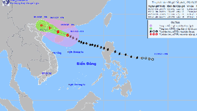
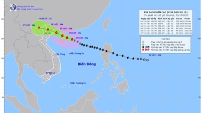
According to data from the National Center for Hydro-Meteorological Forecasting, after continuously increasing in intensity, storm No. 11 (storm Matmo) has maintained level 11 and maintained its moving direction and is about 530 km away from Hoang Sa special zone. However, the forecast still has the possibility of strengthening and increasing in intensity.
Specifically, at 7:00 a.m. on October 4, the center of the storm was at about 18.1 degrees North latitude; 116.5 degrees East longitude, about 470 km East Northeast of Hoang Sa special zone. The strongest wind near the center of the storm was level 11 (103 - 117 km/h), gusting to level 14. The storm moved in a West Northwest direction, at a speed of about 25 km/h.
Forecast, by 7am on October 5, the storm is in the Northwest of the North East Sea, about 90km east of Leizhou Peninsula (China), with strong winds of level 13, gusts of level 16; moving in the West Northwest direction at a speed of 20-25km/h and likely to strengthen. The affected area is the North East Sea. Disaster risk level 3.
By 7:00 a.m. on October 6, the storm had moved into the eastern sea area of the Northern Gulf of Tonkin, on the Vietnam - China border area, with strong winds of level 8, gusts of level 10; moving in the West Northwest direction at a speed of about 20 km/h and gradually weakening.
The affected areas are the North East Sea, the North Gulf of Tonkin and the mainland from Quang Ninh to Ninh Binh . Disaster risk level 3.
By 7 p.m. on October 6, the storm had made landfall in the northeastern part of the Northern region and gradually weakened into a tropical depression, then continued to weaken into a low-pressure area. The center of the low pressure was located in the mountainous area north of the Northern region. The strongest wind was below level 6.
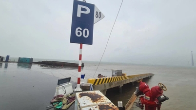
Due to the influence of storm No. 11, the North East Sea area has strong winds of level 8 - 10, the area near the storm's eye has winds of level 11 - 13, gusts of level 16, waves 4 - 6m high, the area near the storm's eye has waves of 6 - 8m, the sea is very rough (extremely destructive, extremely strong waves, can sink large ships).
From the afternoon of October 5, the sea area east of the Northern Gulf of Tonkin (including Bach Long Vi special zone) will have winds gradually increasing to level 6 - 7, then increasing to level 8 - 9.
From the evening of October 5, the Northern Gulf of Tonkin area (including Bach Long Vy, Van Don, Co To, Cat Hai and Hon Dau islands) will have winds gradually increasing to level 8 - 9, waves 2 - 4m high, near the storm center will be level 10 - 11, gusting to level 14, waves 3 - 5m high, and very rough seas (very rough seas, very dangerous for ships).
Coastal areas and islands in Quang Ninh - Hai Phong provinces have storm surges of 0.4 - 0.6 m. Beware of flooding in low-lying coastal areas and river mouths due to surges and big waves from the afternoon and evening of October 5.
The National Center for Hydro-Meteorological Forecasting warns that the weather at sea and in coastal areas during the storm is extremely dangerous and unsafe for any vehicles or structures operating in dangerous areas such as cruise ships, passenger ships, transport ships, cages, rafts, aquaculture areas, dykes, embankments, and coastal routes.
Vehicles are at high risk of capsizing and destruction; flooding due to strong winds, large waves and rising sea levels.
On land, from the night of October 5, the wind from Quang Ninh to Ninh Binh gradually increased to level 6 - 7, and the area near the storm's center reached level 8 - 9. The wind broke tree branches, blew off roofs, causing damage to houses, making it impossible to go against the wind. The inland area of the Northeast had strong winds of level 5, in some places level 6, gusting to level 7 - 8.
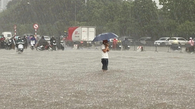
In addition, from the night of October 5 to the end of the night of October 7, in the Northern region, Thanh Hoa and Nghe An, there will be heavy to very heavy rain with common rainfall of 100-200mm, locally over 300mm; in the mountainous and midland areas of the North, the common rainfall will be from 150-250mm, locally over 400mm. Warning of the risk of heavy rain (over 200mm/3 hours).
In Hanoi area, from early morning of October 6 to the end of October 7, there will be moderate rain, heavy rain, and locally very heavy rain with common rainfall of 70 - 150mm, locally over 250mm.
Source: https://baolaocai.vn/bac-bo-bac-trung-bo-san-sang-ung-pho-bao-so-11-co-the-manh-them-post883636.html
![[Photo] Solemn opening of the 8th Congress of the Central Public Security Party Committee, term 2025-2030](https://vphoto.vietnam.vn/thumb/1200x675/vietnam/resource/IMAGE/2025/10/4/f3b00fb779f44979809441a4dac5c7df)


![[Photo] Bustling Mid-Autumn Festival at the Museum of Ethnology](https://vphoto.vietnam.vn/thumb/1200x675/vietnam/resource/IMAGE/2025/10/4/da8d5927734d4ca58e3eced14bc435a3)


![[Photo] General Secretary To Lam attends the 8th Congress of the Central Public Security Party Committee](https://vphoto.vietnam.vn/thumb/1200x675/vietnam/resource/IMAGE/2025/10/4/79fadf490f674dc483794f2d955f6045)


![[VIDEO] Summary of Petrovietnam's 50th Anniversary Ceremony](https://vphoto.vietnam.vn/thumb/402x226/vietnam/resource/IMAGE/2025/10/4/abe133bdb8114793a16d4fe3e5bd0f12)

![[VIDEO] GENERAL SECRETARY TO LAM AWARDS PETROVIETNAM 8 GOLDEN WORDS: "PIONEER - EXCELLENT - SUSTAINABLE - GLOBAL"](https://vphoto.vietnam.vn/thumb/402x226/vietnam/resource/IMAGE/2025/7/23/c2fdb48863e846cfa9fb8e6ea9cf44e7)


Comment (0)