

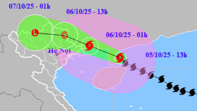
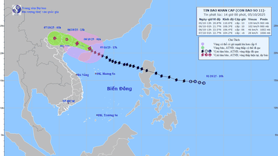
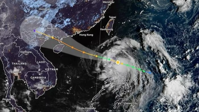
Path of storm No. 11 on the morning of October 5
According to the National Center for Hydro-Meteorological Forecasting, at 7:00 a.m. on October 5, the center of the storm was located at about 20.1 degrees North latitude; 111.6 degrees East longitude, in the sea northeast of Hainan Island (China), about 420km east southeast of Quang Ninh. The strongest wind near the center of the storm was level 12-13 (118-149km/h), gusting to level 16. Moving west-northwest at a speed of 20-25km/h.
From the night of October 5 to noon on October 6, on the mainland coastal areas from Quang Ninh to Hung Yen and Lang Son province, the wind gradually increased to level 6-7, near the eye of the storm level 8-10, gusting to level 11-12. The wind broke tree branches, blew off roofs, causing damage to houses, making it impossible to go against the wind. Inland areas in the Northeast, the wind was strong at level 4-5, in some places level 6, gusting to level 7-8.
Communes/wards in the northeastern region of Quang Ninh province are likely to have strong storm winds of level 9-10, gusting to level 12-13; the remaining communes/wards of Quang Ninh province and coastal areas of Hai Phong city are likely to have strong storm winds of level 8-9, gusting to level 10-11; the coastal communes/wards of Hung Yen province and the northern border communes of Lang Son province are likely to have strong storm winds of level 6-8, gusting to level 9-10; the northeastern region of Bac Ninh province (formerly Bac Giang province) is likely to have strong storm winds of level 6-7, gusting to level 8-9.
Coastal areas and islands in Quang Ninh - Hai Phong provinces have storm surges of 0.4-0.6m. Beware of flooding in low-lying coastal areas and river mouths due to surges and big waves from the afternoon and evening of October 5.
Heavy rain is forecast to focus on the midland and mountainous areas of the North.
Due to the influence of storm No. 11 MATMO, from the night of October 5 to October 7, the Northern region will experience widespread heavy rain.
With the storm forecast to move north, the rain will likely be concentrated in the midlands and mountainous areas of the North. The average rainfall from the night of October 5 to October 7 is about 150 - 250 mm, with some places over 400 mm.
Because the storm moves north, the rain in the Northern Delta and Thanh Hoa will not be as large, generally at 70 - 120 mm, in some places over 200 mm.
From the night of October 5, on the mainland, coastal areas from Quang Ninh to Hung Yen, winds will gradually increase to level 6 - 7, near the storm's eye, level 8 - 9, gusting to level 10 - 11. Inland areas in the Northeast, winds will be strong at level 4 - 5, in some places level 6, gusting to level 7 - 8.
The Center for Hydro-Meteorological Forecasting warns that rain and storm winds are dangerous, but thunderstorms and tornadoes are also important to pay attention to before the storm hits. The circulation of storm No. 11 is wide, so it is possible that while the storm has not yet entered and has not directly affected it, thunderstorms and tornadoes may still appear in the front part of the storm, focusing on the Gulf of Tonkin and the Northern region.
How does storm No. 11 affect the capital Hanoi?
Due to the influence of storm No. 11, from early morning on October 6, Hanoi had winds gradually increasing to level 4-5; from early morning on October 6 to evening on October 7, the city had moderate rain, heavy rain, very heavy rain and thunderstorms in some places. Total rainfall in the central, western and northern areas of the city was 80-150mm, in some places higher than 150mm; in the south of the city was 50-100mm, in some places higher than 100mm.
Heavy rain combined with hydroelectric reservoirs regulating flood discharge will cause water levels in Hanoi's rivers to rise again in the coming days. During this flood, the flood peak on the Da River will be below the level I flood warning level; the Red River and Duong River will be at or near the level I flood warning level; the Day River will be at the level II flood warning level; and inland rivers will be above the level III flood warning level.
According to the Northern Hydrometeorological Station, the rising water level of Hanoi River poses a risk of landslides and flooding in low-lying areas along the river, affecting the safety of key dykes, underground dykes, spillways, bridges, culverts, and traffic routes along the Da, Hong, Duong, Day, Bui, Tich, Cau, and Ca Lo rivers. Heavy rain also causes flooding on many streets with the largest flooding depth commonly being 0.2-0.5m, some places are deeper; flooding time is about 2-4 hours, some places are flooded longer. In addition, it is necessary to guard against landslides in some communes and wards in the suburban areas of Hanoi, such as: Ba Vi, Son Tay, Suoi Hai, Bat Bat, Trung Gia, Kim Anh...
Thu Cuc
Source: https://baochinhphu.vn/du-bao-mua-lon-dien-rong-o-bac-bo-do-hoan-luu-bao-so-11-102251005082255855.htm


![[Photo] Prime Minister Pham Minh Chinh chairs the Government's online conference with localities](https://vphoto.vietnam.vn/thumb/1200x675/vietnam/resource/IMAGE/2025/10/5/264793cfb4404c63a701d235ff43e1bd)
![[Photo] Prime Minister Pham Minh Chinh launched a peak emulation campaign to achieve achievements in celebration of the 14th National Party Congress](https://vphoto.vietnam.vn/thumb/1200x675/vietnam/resource/IMAGE/2025/10/5/8869ec5cdbc740f58fbf2ae73f065076)


![[VIDEO] Summary of Petrovietnam's 50th Anniversary Ceremony](https://vphoto.vietnam.vn/thumb/402x226/vietnam/resource/IMAGE/2025/10/4/abe133bdb8114793a16d4fe3e5bd0f12)

![[VIDEO] GENERAL SECRETARY TO LAM AWARDS PETROVIETNAM 8 GOLDEN WORDS: "PIONEER - EXCELLENT - SUSTAINABLE - GLOBAL"](https://vphoto.vietnam.vn/thumb/402x226/vietnam/resource/IMAGE/2025/7/23/c2fdb48863e846cfa9fb8e6ea9cf44e7)


Comment (0)