
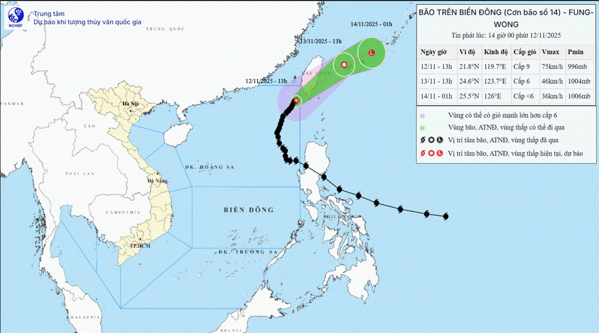
According to the National Center for Hydro-Meteorological Forecasting, at 13:00 on November 12th, the typhoon's center was located at approximately 21.8 degrees North latitude and 119.7 degrees East longitude, in the northeastern part of the North East Sea.
The strongest winds near the center of the storm are at force 8-9 (62-88 km/h), with gusts up to force 11. It is moving in a North-Northeast direction at a speed of approximately 10 km/h.
Forecasts indicate that by 13:00 on November 13th, the storm will be located in the sea northeast of Taiwan (China) and gradually weaken into a tropical depression, with wind speeds of level 6, gusting to level 8. The storm is moving northeast at a speed of 20 km/hour. The affected area is the northeastern part of the North East Sea. The level of natural disaster risk is level 3.
By 1:00 AM on November 14th, the storm in the sea northeast of Taiwan (China) had wind speeds below level 6, gradually weakening into a low-pressure area, moving in an east-northeast direction at a speed of about 20 km/hour.
Due to the impact of the storm, the northeastern part of the North East Sea will experience strong winds of force 6-7; in the area near the storm's center, winds will be strong at force 8-9, gusting to force 11, with waves 3-5m high, and 5-7m near the storm's center, resulting in very rough seas.
All vessels operating in the aforementioned hazardous areas are susceptible to the effects of thunderstorms, tornadoes, strong winds, and high waves.
PVSource: https://baohaiphong.vn/bao-so-14-di-chuyen-cham-huong-ve-dao-dai-loan-526437.html
![[Photo] First session of the 14th Congress of the Vietnam Trade Union](https://vphoto.vietnam.vn/thumb/1200x675/vietnam/resource/IMAGE/2026/06/03/1780465947883_ndo_br_img-3852-jpg.webp)
![[Photo] General Secretary and President To Lam presides over a meeting with the Central Organizing Committee.](https://vphoto.vietnam.vn/thumb/1200x675/vietnam/resource/IMAGE/2026/06/03/1780482764658_a1-bnd-4741-3342-jpg.webp)


![[Photo] Secretary of the National Assembly Party Committee, Chairman of the National Assembly presides over the meeting of the Standing Committee and Executive Committee of the National Assembly Party Committee.](https://vphoto.vietnam.vn/thumb/1200x675/vietnam/resource/IMAGE/2026/06/03/1780480353201_ndo_br_bnd-2585-jpg.webp)


![[Video] Sunset at Lap An Lagoon – Where the sun sets over the fishing nets](https://vphoto.vietnam.vn/thumb/1200x675/vietnam/resource/IMAGE/2026/05/31/1780192137701_beach-landscape-sea-water-nature-grass-745871-pxhere-com.jpeg)


Comment (0)