
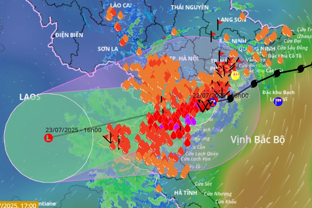
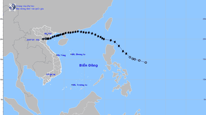
The movement direction of storm No. 3 updated as of the afternoon of July 22. Source: Vietnam Disaster Monitoring System
Storm circulation continues to cause widespread heavy rain, especially in Thanh Hoa, Nghe An , southern Phu Tho and Son La.
The strongest wind near the storm center is level 8 (62-74km/h), gusting to level 10; moving west at a speed of 10-15km/h. In the next 24 hours, the storm will move west-southwest at 10-15km/h and weaken into a tropical depression, then continue to weaken into a low pressure area over Upper Laos.
The meteorological agency continues to warn that the weather at sea and in coastal areas during the storm is extremely dangerous and unsafe for any vehicles or structures operating in the danger zone such as: cruise ships, passenger ships, transport ships, cages, rafts, aquaculture areas, dykes, embankments, coastal routes. Vehicles are at high risk of capsizing, destruction, and flooding due to strong winds, storms, whirlwinds, and large waves.

At the same time, on land, coastal areas from Quang Ninh to Nghe An have strong winds of level 6-7, near the storm center level 8, gusting to level 10; inland areas of the provinces and cities of Hai Phong, Hung Yen, Bac Ninh, Hanoi , Ninh Binh and Thanh Hoa have gusts of level 6-8. Level 8 winds can break tree branches, blow off roofs, causing damage to houses.
Last night and today (July 22), in the Northern Delta region, the area from Thanh Hoa to Ha Tinh had moderate rain, heavy rain and thunderstorms, locally very heavy rain; especially in Hung Yen, Ninh Binh, Thanh Hoa, Nghe An, there was heavy to very heavy rain.
Rainfall from 7pm to 3pm on July 22 was over 250mm in some places such as: Dong Giao station (Ninh Binh) 253.8mm, Sam Son station (Thanh Hoa) 398.6mm, Nhu Xuan station (Thanh Hoa) 374.0mm, Chau Nga station (Nghe An) 316.8mm,... |
From this evening to tomorrow morning (July 23), Thanh Hoa, Nghe An, southern Phu Tho and Son La will continue to experience heavy to very heavy rain with common rainfall of 40-100mm, locally over 200mm. Warning of risk of heavy rain (>150mm/3 hours).
Notably, from July 24-25, the Northern region and from Thanh Hoa and Nghe An are likely to continue to have moderate rain, heavy rain and thunderstorms, with some places having very heavy rain.
In addition, the meteorological agency also warned that in the next 6 hours there is a risk of flash floods, landslides, and land subsidence on steep slopes and small streams in the provinces of Son La, Phu Tho, Lao Cai, Thanh Hoa, Nghe An, and Ha Tinh. |
NDS
Source: https://baothanhhoa.vn/bao-so-3-chua-tan-thanh-hoa-van-o-trong-tam-bao-voi-suc-gio-giat-cap-10-255757.htm


Comment (0)